Current Weather Conditions on 26th August 2014 @ 11.00 pm.
The rainfall activity had improved from 23rd August on wards and light to medium rainfall has been reported from many places in Gujarat & Saurashtra.
The Western end of Monsoon trough continues to run close to the foot-hills of the Himalayas while the Eastern end has shifted Southwards and now passes through Balya, Gaya, Jamshedpur,Balasore and thennce Southeastwards to North Bay of Bengal.
The Off-shore trough at mean sea level from South Maharashtra coast to Kerala coast persists.
The East West shear zone roughly along 17 N between 3.1 Kms. & 4.5 Kms. above mean sea level with an embedded Cyclonic Circulation over West Central Bay of Bengal & vicinity persists. Under its influence, a low pressure area would form over West Central & adjoining Northwest Bay of Bengal off North Andhra Pradesh- South Odisha coasts by 28th August.
The Western disturbance as an Upper Air Cyclonic Circulation over Afghanistan & neighborhood extends uo to 3.1 Kms. above mean sea level persists.
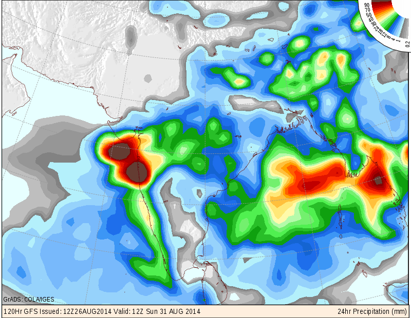
COLA/IGES GFS Precipitation Forecast Map Valid 1200 UTC 31st August 2014
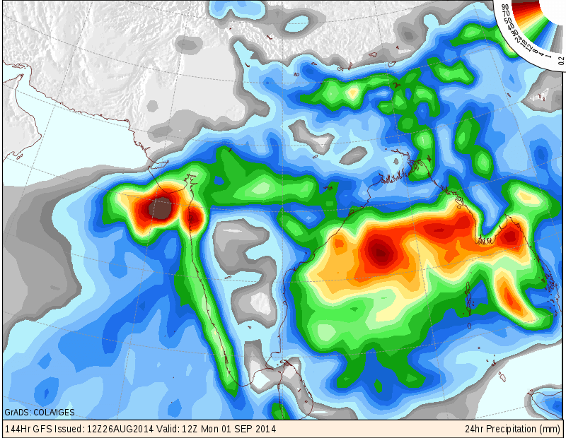
COLA/IGES GFS Precipitation Forecast Map Valid 1200 UTC 1st September 2014
COLA/IGES SLP Forecast Map Valid 1200 UTC 28th August 2014
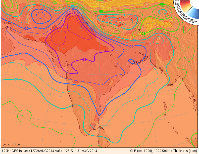
COLA/IGES SLP Forecast Map Valid 1200 UTC 31st August 2014
IMD MSL Pressure Forecast Map Valid for 1200 UTC 28th August 2014
IMD Daily All India Mean Rainfall (mm./day) Forecast Till 2nd September 2014
The above rainfall graph shows that rainfall activity over whole India average will be good in last two days of August as well as the first two days of September. Overall above average rainfall expected for India for week ending 2nd September.
Forecast: 27th August to 2nd September 2014
Saurashtra, Gujarat & Kutch :
27th to 29th August Saurashtra, Kutch & Gujarat scattered showers at a few places. South Gujarat and some parts of Central Gujarat could get off & on scattered light rain/showers during the forecast period.
30th August to 2nd September major portion of Saurashtra & Gujarat expected to get medium to heavy rainfall during the forecast period while some parts of Saurashtra & Gujarat would get light to medium rainfall. Kutch is also expected to get rain from this round, however, update will be given once the Low Pressure forms over the Bay of Bengal.
Overall looking at the current forecast models this round of rainfall will be better than the earlier round that has just ended.
સૌરાષ્ટ્ર, ગુજરાત અને કચ્છ :
તારીખ ૨૭ ઓગસ્ટ થી ૨ સપ્ટેમ્બર ૨૦૧૪:
આગલો રાઉન્ડ પૂરો થયો છે પરંતુ તારીખ ૨૭ થી ૨૯ ના સૌરાષ્ટ્ર અને ગુજરાત માં છુટા છવાયા ઝાપટા અને દક્ષીણ ગુજરાત ને મધ્ય ગુજરાત માં છુટા છવાયા ઝાપટા અથવા હળવો વરસાદ.
નવો રાઉન્ડ:
તારીખ ૩૦ ઓગસ્ટ થી ૨ સપ્ટેમ્બર દરમ્યાન સૌરાષ્ટ્ર અને ગુજરાત ના મોટા ભાગ માં મધ્યમ અને ભારે વરસાદ થશે બાકી ના વિસ્તારો માં હળવો માધ્યમ વરસાદ થશે. કચ્છ માં વરસાદ ના ઊજળા સંજોગો છે પરંતુ બંગાળની ખાડી માં લો પ્રેસર થયે કચ્છ માટે ની અપડેટ આપવામાં આવશે.