Current Weather Conditions on 20th August 2014 @ 11.00 pm.
The rainfall activity has been less over most parts of Saurashtra, Kutch & Gujarat.
REGION AVERAGE till 20th August 2014 @ 8.30 am. IST:
SAURASHTRA REGION has received 416 mm. rainfall which is 65.33 % against normal seasonal rainfall of 637 mm.
KUTCH REGION has received 167 mm. rainfall which is 43.15 % against normal seasonal rainfall of 387 mm.
NORTH GUJARAT REGION has received 316 mm. rainfall which is 46.87 % against normal seasonal rainfall of 675 mm.
EAST CENTRAL GUJARAT REGION has received 443.5 mm. rainfall which is 54.76 % against normal seasonal rainfall of 810 mm.
SOUTH GUJARAT REGION has received 757 mm. rainfall which is 55.75 % against normal seasonal rainfall of 1358 mm.
WHOLE GUJARAT STATE has received 458.3 mm. rainfall which is 57.50 % against normal seasonal rainfall of 797 mm.
All India Sub-Division Wise Rainfall Performance till 20th August 2014

Whole India departure of rainfall from 1st June to 20th August 2014 is -18% while it is -32% for Gujarat and -21% for Saurashtra & Kutch Sub-Division.
The axis of monsoon trough at mean sea level continues to run close to the foothills of Himalayas.
The upper air cyclonic circulation lies over Sub-Himalayan West Bengal & Sikkim in lower levels persists.
The trough from Sub Himalayan West Bengal & Sikkim to North Bay of Bengal across Gangetic West Bengal between 3.1 Kms. & 5.8 Kms. above sea level persists.
The upper air cyclonic circulation over South Interior Karnataka & neighborhood extending up to 1.5 Kms. above mean sea level persists.
The East West shear zone roughly along Latitude 10.0°N across south Peninsula extending between 3.1 & 4.5 Kms. above mean sea level persists.
The trough from East Madhya Pradesh to Kerala across interior Karnataka extending up to 0.9 Kms. above mean sea level persists.
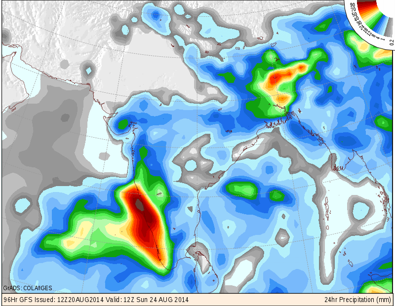
COLA/IGES GFS Precipitation Forecast Map Valid 1200 UTC 24th August 2014
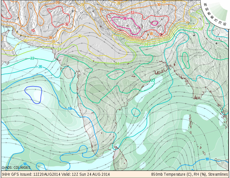
COLA/IGES 850 mb. Streamlines Forecast Map Valid 1200 UTC 24th August 2014
COLA/IGES 850 mb. Streamlines Forecast Map Valid 1200 UTC 25th August 2014
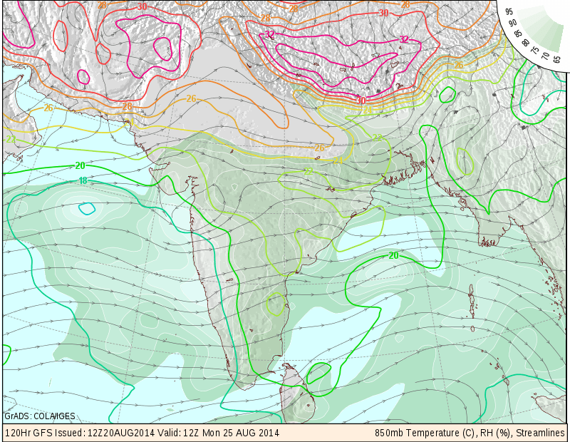
The above 850 mb. charts show a Cyclonic Circulation near Goa on 24th August and moving Northwards along Konkan coast the next day.
IMD Daily All India Mean Rainfall (mm./day) Forecast Till 27th August

The above rainfall graph shows that rainfall activity over whole India will be less than normal till 22nd August and the rainfall activity expected to pick up during 23rd to 25th August.
Forecast: 21st August to 26th August 2014
Saurashtra, Gujarat & Kutch :
21st & 22nd August most parts of Saurashtra, Kutch & Gujarat scattered showers at a few places. South Gujarat and some parts of Central Gujarat could get off & on scattered light rain/showers during the forecast period.
23rd to 26th August 50% of Saurashtra & Kutch expected to get light rain or medium rain/showers during the forecast period while rest of Saurashtra would get scattered showers at a few places. South Gujarat and some parts of Central Gujarat could get scattered light to medium rainfall or sharp showers during the forecast period.
In short conditions to be better during 23rd to 25th/26th August compared to last few days.
સૌરાષ્ટ્ર, ગુજરાત અને કચ્છ :
તારીખ ૨૧ થી ૨૬ ઓગસ્ટ ૨૦૧૪:
તારીખ ૨૧ અને ૨૨ ના સૌરાષ્ટ્ર , કચ્છ અને ઊત્તર ગુજરાત માં છુટા છવાયા ઝાપટા અને દક્ષીણ ગુજરાત ને મધ્ય ગુજરાત માં છુટા છવાયા ઝાપટા અથવા હળવો વરસાદ.
તારીખ ૨૩ થી ૨૬ ઓગસ્ટ દરમ્યાન સૌરાષ્ટ્ર, કચ્છ અને ઊતર ગુજરાત માં હળવો મધ્યમ વરસાદ અથવા છુટા છવાયા ઝાપટા અને બાકી ના ૫૦% વિસ્તાર માં સામાન્ય છુટા છવાયા ઝાપટા . દક્ષીણ ગુજરાત માં છૂટો છવાયો હળવો મધ્યમ વરસાદ અથવા છુટા છવાયા ઝાપટા પડશે. મધ્ય પૂર્વ ગુજરાત ના અમૂક ભાગ માં પણ છુટા છવાયા ઝાપટા અથવા હળવો વરસાદ પડશે.
ટૂક માં તારીખ ૨૩ થી ૨૫/૨૬ દરમ્યાન વાતાવરણ માં થોડો સુધારો જોવા મળશે.
Scroll Up