Current Weather Conditions on 9th October 2014 @ 8.30 am.
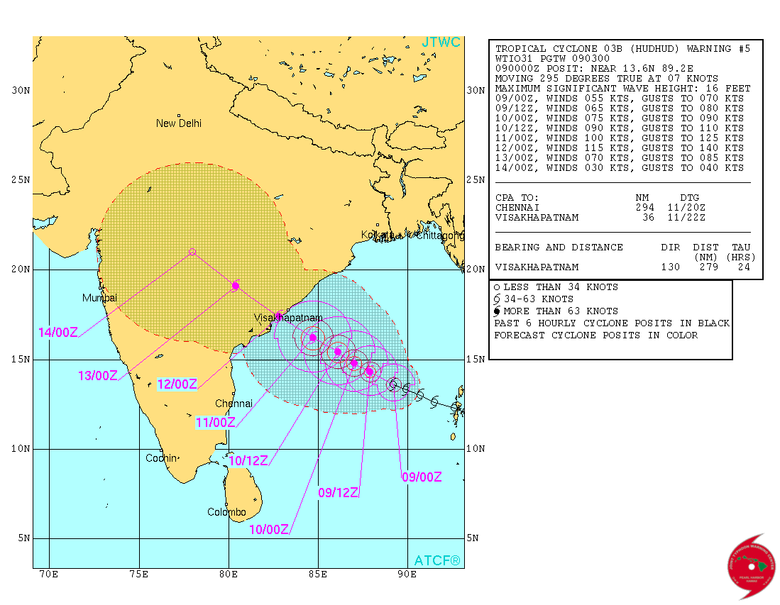
JTWC has isssued Tropical Cyclone Warning Number 5 @ 0300 UTC on 9-10-2014 for conditions at 0000 UTC of 9-10-2014. System 03B.Hudhud had 55 knots wind speed with 982 mb. Central Pressure located at Lat. 13.6°N & Long. 89.2°E over the East Central Bay of Bengal.
JTWC Tropical Cyclone 03B.HUDHUD Warning No. 5
Forecast Cyclone Track
IMD National Bulletin available here
RSMC Bulletin available here
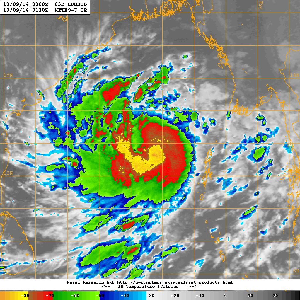
NRL IR Satellite Image of 03B.HUDHUD ( Cyclonic Storm “HUDHUD” )
on 9th October 2014 @ 01.30 UTC (8.00 am. IST )
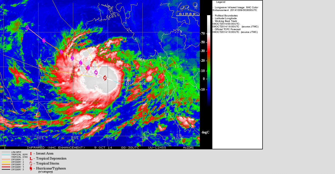
UW-CIMMS IR Satellite Image of 03B.HUDHUD ( Cyclonic Storm “HUDHUD”)
on 9th October 2014 @ 00.30 UTC (6.00 am. IST )
| UW-CIMSS Automated Satellite-Based Advanced Dvorak Technique (ADT) Version 8.2.1 Tropical Cyclone Intensity Estimation Algorithm |
|
| Current Intensity Analysis | |
                     UW - CIMSS
              ADVANCED DVORAK TECHNIQUE
                  ADT-Version 8.2.1
         Tropical Cyclone Intensity Algorithm

             ----- Current Analysis -----
     Date :  09 OCT 2014    Time :   013000 UTC
      Lat :   13:42:07 N     Lon :   89:03:25 E


                CI# /Pressure/ Vmax
                3.7 / 990.8mb/ 59.0kt


             Final T#  Adj T#  Raw T#
                3.7     3.7     3.7

 Center Temp : -68.2C    Cloud Region Temp : -76.2C

 Scene Type : EMBEDDED CENTER CLOUD REGION

 Positioning Method : FORECAST INTERPOLATION

 Ocean Basin : INDIAN
 Dvorak CI > MSLP Conversion Used : PACIFIC

 Tno/CI Rules : Constraint Limits : NO LIMIT
                   Weakening Flag : OFF
           Rapid Dissipation Flag : OFF

 C/K/Z MSLP Estimate Inputs :
  - Average 34 knot radii :   62km
  - Environmental MSLP    : 1009mb

 Satellite Name :    MET7
 Satellite Viewing Angle : 40.1 degrees

****************************************************
|
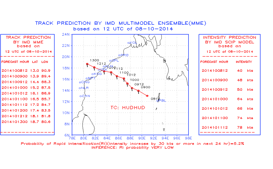
Forecast track by IMD Multimodel Ensemble (MME) Valid 12.00 UTC of 8-10-2014
For NWP Tropical Cyclone Genesis Potential Animation Track of the current System Click here
Forecast: 9th October to 12th October 2014
Cyclonic Storm “HUDHUD” – 03B.HUDHUD:
Cyclonic Storm “HUDHUD”. The System is expected to track mainly West Northwest towards North Andhra Pradesh/South Odisha Coast for next three days. The System is expected to strengthen further to Sever Cyclonic Storm and then to a Very Severe Cyclonic Stom by 11th October. Landfall expected around 12th October vicinity of Vishakhapatnam as per both GSF as well as ECMWF available forecast runs.
Note: Refer/Rely on IMD/RSMC Bulletins/Advisories