Current Weather Conditions on 22nd October 2014 @ 7.00 am.
Weather Conditions of Saurashtra, Kutch & Gujarat
The Maximum Temperature over most parts of Saurashtra, Kutch & Gujarat were near normal to about 1 Degrees above normal at most places except Naliya which was 4 Degrees above normal. The Minimum Temperature has been about 1 to 2 Degrees C. above normal at most places of the regions.
From IMD Inference issued at 2015 hours IST 21st October:
A Low Pressure area over Southeast Arabian Sea and neighborhood persists. The System is likely to become a Well Marked low Pressure area during the next 48 hours. A trough extends from this System to East Central Arabian Sea off Maharashtra coast.
The trough of low over southeast Bay of Bengal and neighborhood persists.
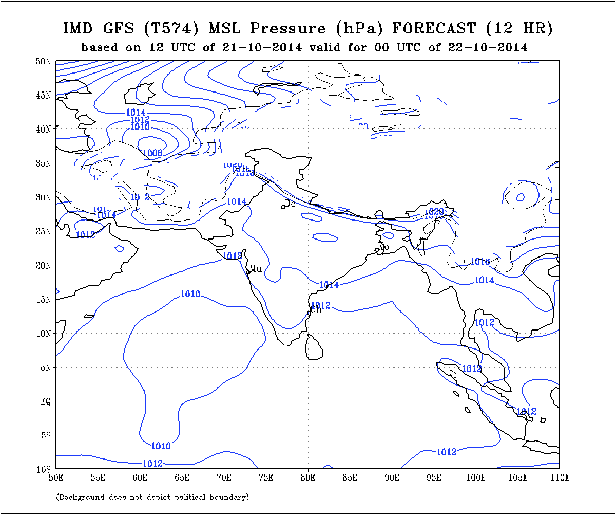
Observing the GFS MSLP charts the Low Pressure area is currently very weak at 1010 millibars.
IMD GFS (T574) MSLP Forecast Chart Valid 22nd October 2014 @ 00 UTC
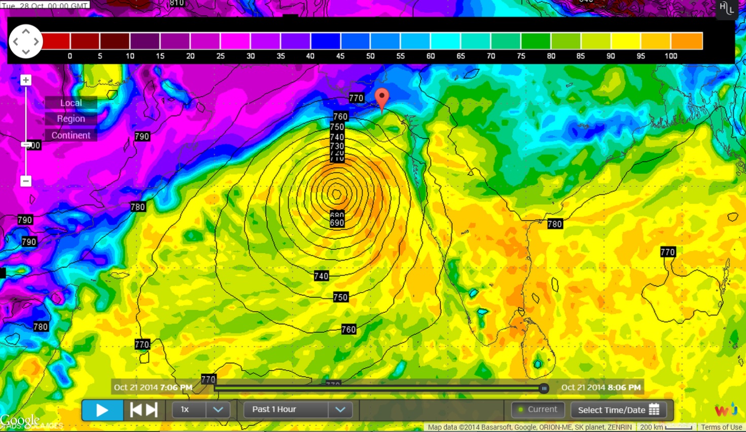
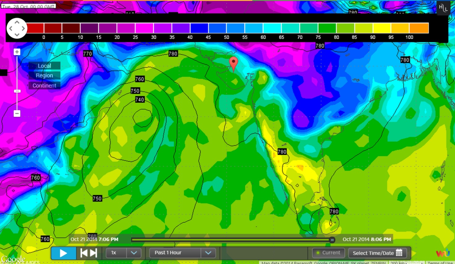
Two major Forecast models viz. GFS & ECMWF have different outcome on the further developing as well as track for the System that is under development.
Wunderground ECMWF 925 hPa Forecat Chart Valid 28th October 00 UTC
Wunderground GFS 925 hPa Forecat Chart Valid 28th October 00 UTC
Forecast: 22nd to 29th October 2014
ECMWF & GSF both have different out come for the System developing in the South Arabian Sea. Forecast outcome will change and updates will be given as and when available. ECMWF tracks this as a strong System towards Gujarat & Saurashtra, so farmers should be cautious. Currently there is hardly any confidence in the final outcome because of completely different tracks for both these models. Western Disturbance is expected around 24th/25th over Pakistan/North India, so there is a possibility of WD affecting the final outcome of the Arabian Sea System. Future WD during the forecast period could also affect the outcome.
Forecast: 22nd October to 29th October 2014
The Maximum as well as Minimum Temperature is expected to be near normal or slightly above normal from 22nd to 25th October. However, the Maximum Temperature is expected to decrease during the latter parts of the forecast period. Clouding could affect the Minimum Temperature to increase during the latter parts of the forecast period.
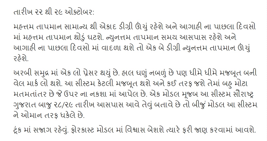
તારીખ ૨૨ થી ૨૯ ઓક્ટોબર:
મહત્તમ તાપમાન સામાન્ય થી એકાદ ડીગ્રી ઊંચું રહેશે અને આગાહી ના પાછલા દિવસો માં મહત્તમ તાપમાન થોડું ઘટશે. ન્યુનત્તમ તાપમાન સમય આસપાસ રહેશે અને આગાહી ના પાછલા દિવસો માં વાદળા થશે તો એક બે ડીગ્રી ન્યુનત્તમ તાપમાન ઊંચું રહેશે.
અરબી સમુદ્ર માં એક લો પ્રેસર થયું છે. હાલ ઘણું નબળું છે પણ ધીમે ધીમે મજબૂત બની વેલ માર્ક લો થશે. આ સીસ્ટમ કેટલી મજબૂત થશે અને કઈ તરફ જશે તેમાં બહુ મોટા મતમતાંતર છે જે ઉપર ના નકશા માં આપેલ છે. એક મોડલ મૂજબ આ સીસ્ટમ સૌરાષ્ટ્ર ગુજરાત બાજુ ૨૮/૨૯ તારીખ આસપાસ આવે તેવું બતાવે છે તો બીજું મોડલ આ સીસ્ટમ ને ઓમાન તરફ ધકેલે છે.
ટૂંક માં સજાગ રહેવું. ફોરકાસ્ટ મોડલ માં વિશ્વાસ બેશશે ત્યારે ફરી જાણ કરવામાં આવશે.
Scroll Up