Current Weather Conditions on 23rd August 2015 @ 7.30 am. IST
Last Night Conditions:
The Axis of Monsoon trough now passes through Firozpur, Ambala, Bareilly, Gorakhpur, Muzaffarpur, Balurghat and thence Eastwards to Nagaland across Assam & Meghalaya.
There is an Upper Air Cyclonic Circulation over North Bangladesh and adjoining Sub-Himalayan West Bengal & Sikkim extending upto 3.1 km above mean sea level. There is a trough from this system to North Bay of Bengal extending upto 4.5 km above mean sea level. A Low Pressure area may develop over north Bay of Bengal from this UAC in a couple of days.
There is a feeble off-shore trough at mean sea level from Karnataka coast to Kerala coast.
There is a Western Disturbance as an Upper Air Cyclonic Circulation over North Pakistan & neighborhood extending upto 3.1 km above mean sea level.
There are two Systems (Cyclones) in the West Pacific, Typhoon GONI & Typhoon ATSANI. GONI attained a maximum speed of 115 knots on 18th August while ASTANI attained maximum speed of 140 knots on 19th August. Currently GONI as well as ATSANI has 80 knots wind speed ( 1 knot=1.85 kms.) and both these Typhoons are now tracking North Northeastwards and subsequently will track Northeastwards.
Forecast: 23rd August to 28th August 2015
Saurashtra, Kutch & Gujarat
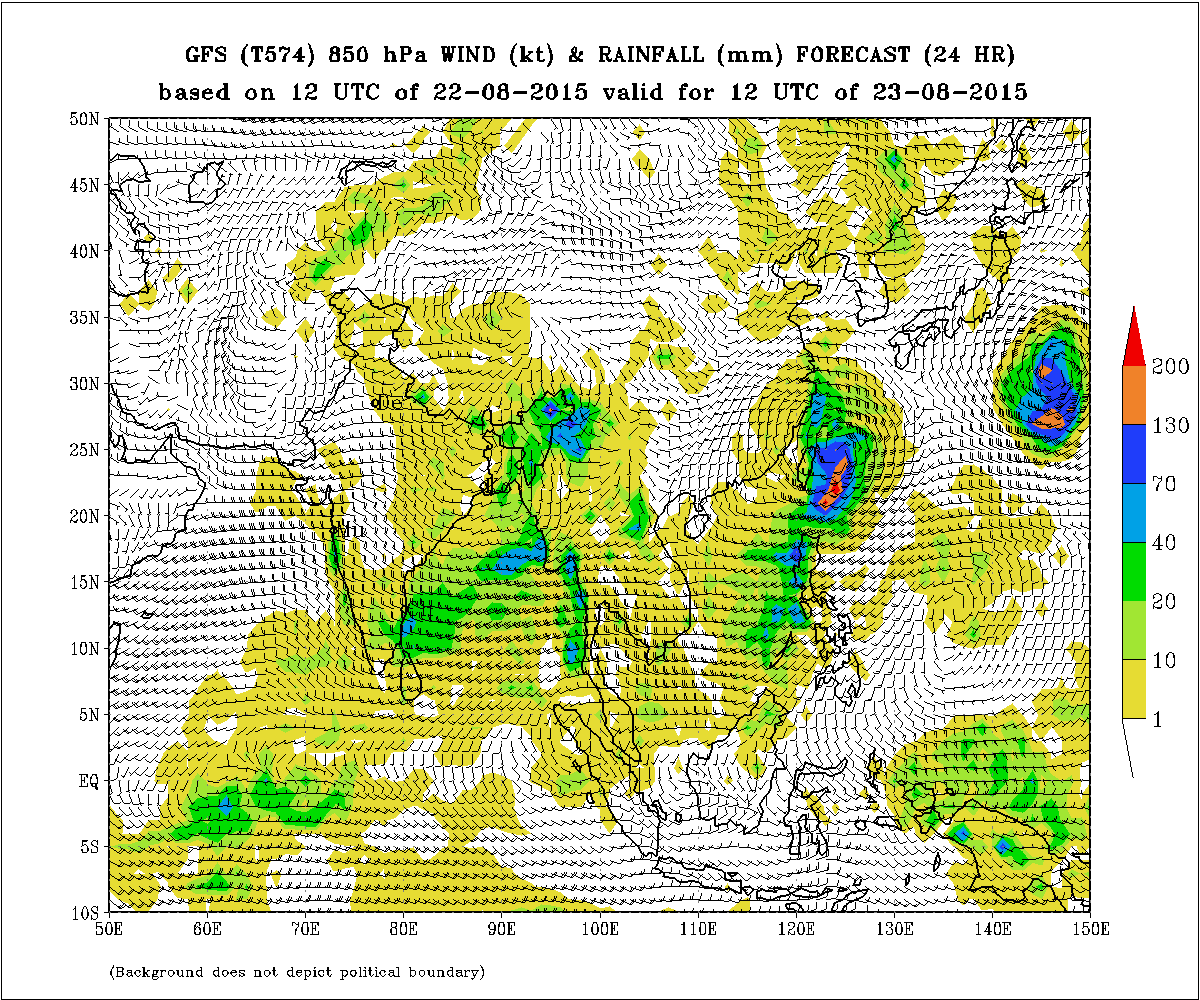
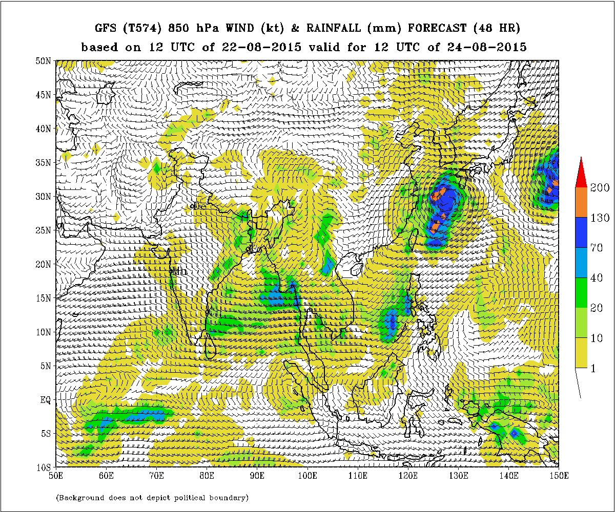
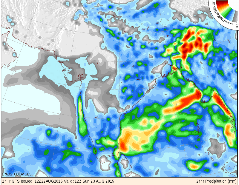
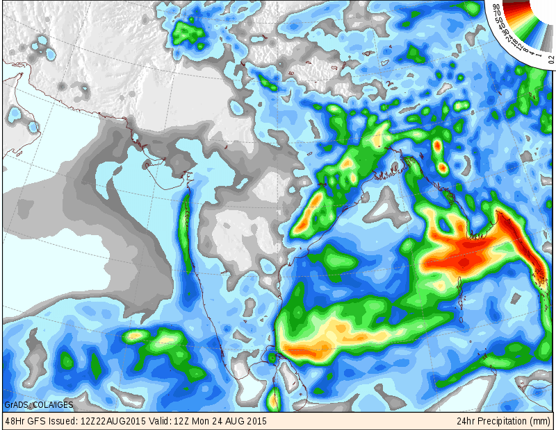
Wait for good rain will continue during the forecast period since no meaningful rainfall is forecast for Saurashtra, Kutch & Gujarat from 23rd to 28th August. Only scattered showers or drizzle over parts of Saurashtra, Kutch & Gujarat on some days. IMD as well as COLA/IGES maps are given for next two days showing possible areas of scattered showers/drizzle.
IMD GFS (T574) 850 hPa Winds (kt) & Rainfall (mm) for 23rd August 2015
IMD GFS (T574) 850 hPa Winds (kt) & Rainfall (mm) for 24th August 2015
COLA/IGES Forecast Precipitation Valid for 1200 UTC 23-08-2015
COLA/IGES Forecast Precipitation Valid for 1200 UTC 24-08-2015
તારીખ 23 ઓગસ્ટ સવારે 7.30 વાગ્યે
હવે ચોમાસું ધરી પંજાબ ના ફિરોઝપુર અંબાલા બરેલી ગોરખપુર મુઝફરપુર બાલૂરઘાટ અને ત્યાં થી પૂર્વ તરફ આસામ મેઘાલય થઇ ને નાગાલેન્ડ સુધી લંબાય છે.
3.1 કિમી સુધી નું UAC ઊત્તર બંગલા દેશ અને લાગુ સબ હિમાલયન પશ્ચિમ બંગાળ ઉપર છે. આ UAC થી એક ટ્રફ ઊત્તર બંગાળની ખાડી સુધી લંબાય છે. તેની અસર રૂપે આવતા બેક દિવસ માં ઊત્તર બંગાળની ખાડી માં એક લો પ્રેસર થવાની સાંભાના છે.
એક નબળો ઓફ શોર ટ્રફ દરિયા ના લેવલે કર્નાટક થી કેરલા સુધી લંબાય છે.
વેસ્ટર્ન ડીસ્ટર્બન્સ હાલ ઊત્તર પાકિસ્તાન અને લાગુ વિસ્તારો માં છે જે UAC 3.1 કિમી ની ઉંચાયે છે.
પશ્ચિમ પ્રશાંત મહાસાગર માં બે વાવાઝોડા છે જેને તે વિસ્તાર માં ટાયફૂન કહે છે. એક છે ટાયફૂન GONI અને બીજો છે ટાયફૂન ATSANI. GONI ની પવન ની ઝડપ વધી ને 115 knot થઇ હતી અને ATSANI ની પવન ની ઝડપ 140 knot થઇ હતી. બંને સીસ્ટમ હાલ 80 knot પવન ની ઝડપ છે અને બંને હાલ ઊત્તર ઊત્તર પૂર્વ તરફ ગતિ કરે છે અને ત્યાર બાદ ઊત્તર પૂર્વ બાજુ જશે. ( 1 knot=1.85 km/hour)
સૌરાષ્ટ્ર કચ્છ ગુજરાત:
તારીખ 23 ઓગસ્ટ થી 28 ઓગસ્ટ 2015
સૌરાષ્ટ્ર, ગુજરાત અને કચ્છ માં સાર્વત્રિક સારા વરસાદ ની રાહ જોવા નું ચાલુ રહેશે. તારીખ 23 થી 28 દરમ્યાન અંશત વાદળ છાયું વાતાવરણ. આગાહી સમય ગળાના અમૂક દિવસો માં કોઈ કોઈ જગ્યાએ છુટ્ટા છવાયા ઝાપટા. તારીખ 23 અને 24 માટે IMD તેમજ COLA/IGES ના નકશા આપેલ છે.