Weather Forecast In Akila Daliy Dated 9th September 2015
Update 8th September 2015 8.00 pm.
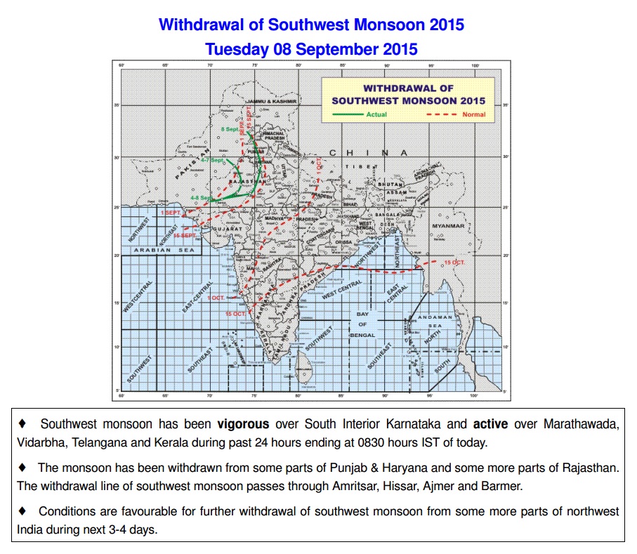
IMD Map For Withdrawal of Southwest Monsoon Till 8th September 2015
દક્ષીણ પશ્ચિમ ચોમાસું પંજાબ અને હરિયાણા ના અમૂક ભાગ તેમજ રાજસ્થાન ના થોડા વધુ ભાગ માંથી વિદાય લીધી છે. હાલ ચોમાસું પરત ફરવાની રેખા અમૃતસર હિસાર અને બારમેર માંથી પસાર થાય છે.
આવતા 3 થી 4 દિવસ માં દક્ષીણ પશ્ચિમ ચોમાસું ઊત્તર પશ્ચિમ ભારત ના વધુ ભાગો માંથી વિદાય લે તેવા સંકેતો છે.
Current Weather Conditions on 8th September 2015 @ 8.00 am. IST
Weather Conditions:
The trough in lower levels from Marathawada to Lakshadweep across interior Karnataka extending upto 1.5 km above mean sea level persists.
The Upper Air Cyclonic Circulation over West Central Bay of Bengal between 1.5 & 3.6 km above mean sea level persists.
There is an Upper Air Cyclonic Circulation over South Pakistan & neighborhood between 1.5 km & 3.1 km above mean sea level.
The feeble Western Disturbance as an Upper Air Trough in Mid-Tropospheric Westerlies roughly along Longitude 73.0°E and north of Latitude 30.0°N persists.
Forecast: 8th to 13th September 2015
Saurashtra & Gujarat:
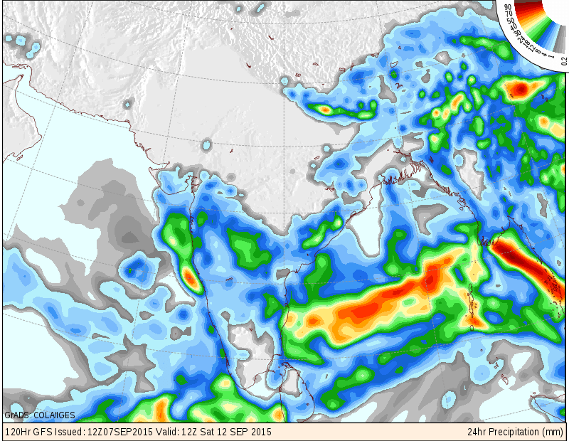
Few places got some light rain on one or two days and scattered showers over some more places of Saurashtra, Gujarat & Kutch. Forecast of Scattered showers or light rain over parts of Saurashtra & Gujarat on some days of forecast period and Isolated places could get medium rain. The quantum of rainfall will be more than last forecast period. IMD as well as COLA/IGES maps are given for 8th & 11th/12th September showing possible areas of scattered showers/light rain. Isolated location getting medium rain.
Kutch: No or very little rain for the area.
Monsoon is not yet over for Saurashtra, Gujarat & Kutch.
Note: An Advance Indication is given below with 50 to 70% confidence in validity.
A Well Marked Low Pressure is expected over the Bay Of Bengal after the end of current Forecast period.
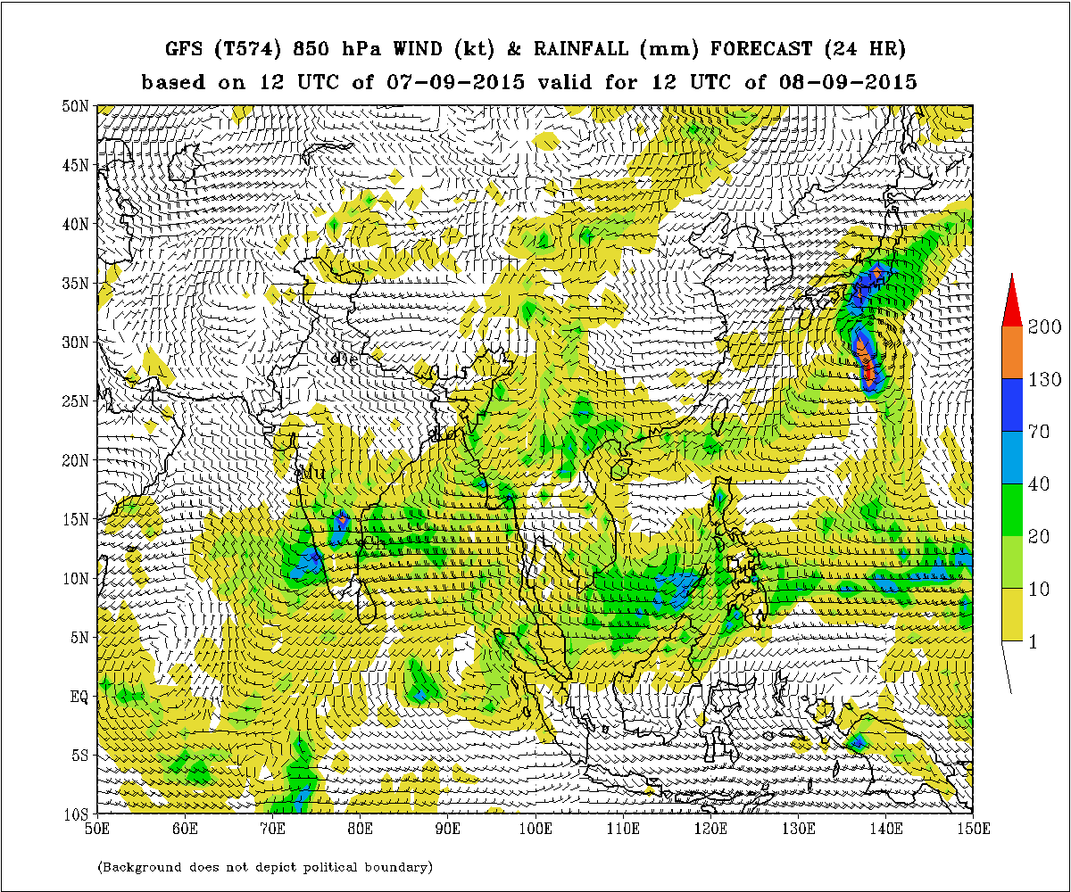
IMD GFS (T574) 850 hPa Winds (kt) & Rainfall (mm)
valid for 12 UTC 8th September 2015
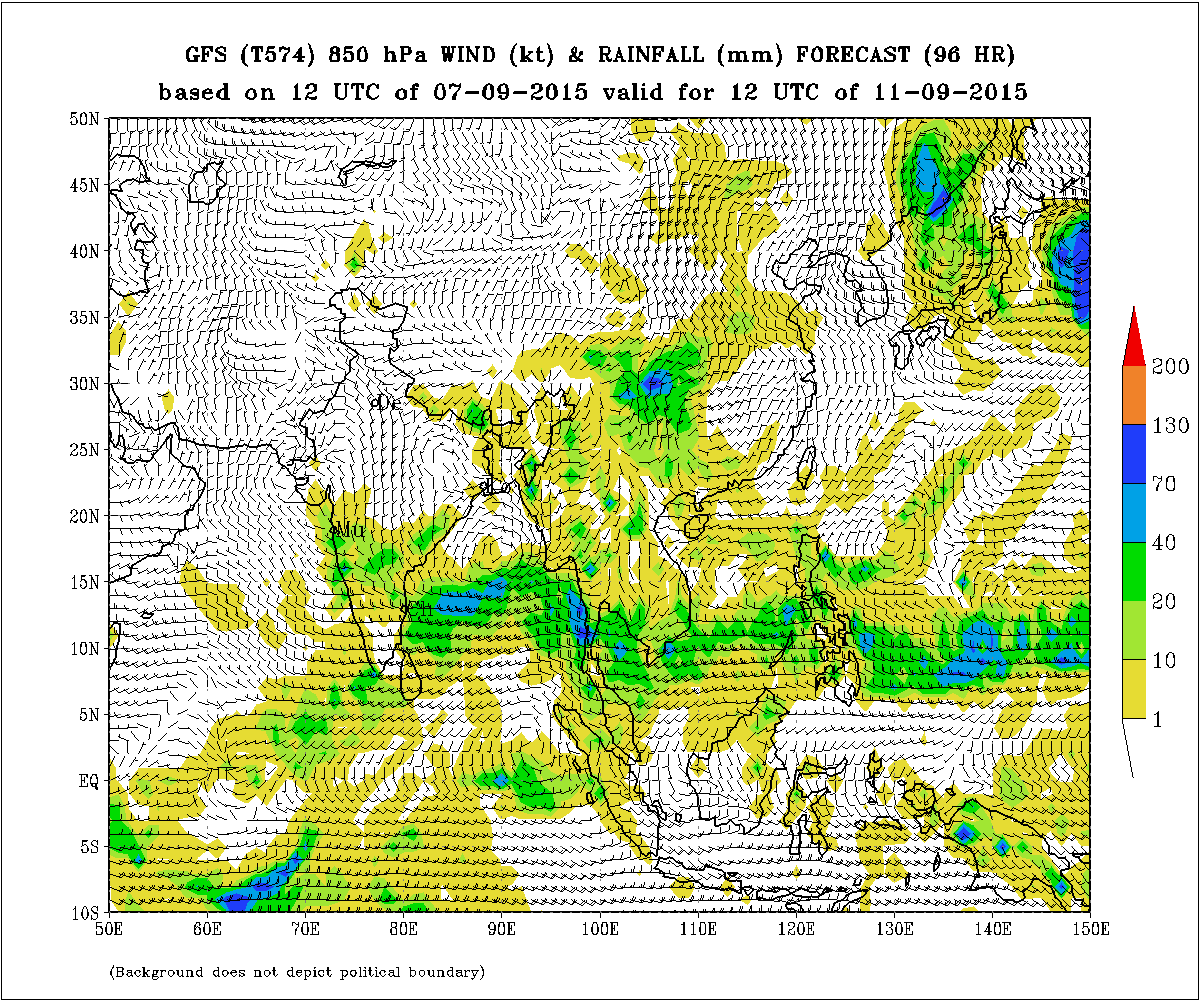
IMD GFS (T574) 850 hPa Winds (kt) & Rainfall (mm)
valid for 12 UTC 11th September 2015
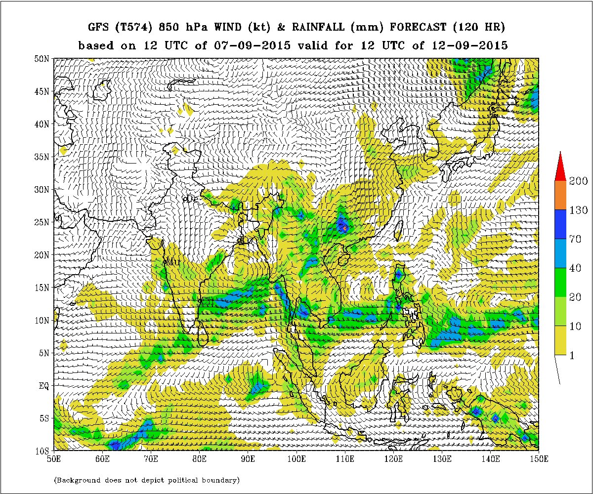
IMD GFS (T574) 850 hPa Winds (kt) & Rainfall (mm)
valid for 12 UTC 12th September 2015
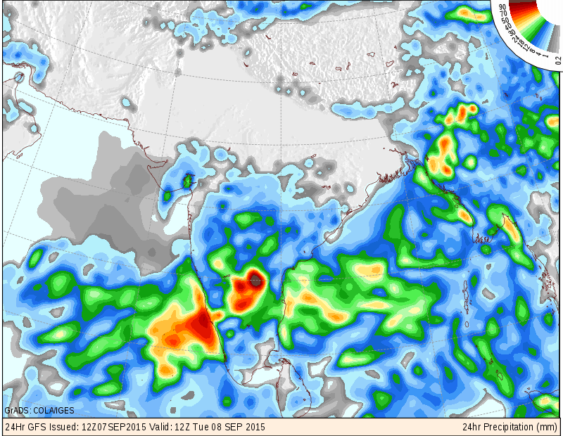
COLA/IGES Forecast Precipitation Valid for 12 UTC 08-09-2015
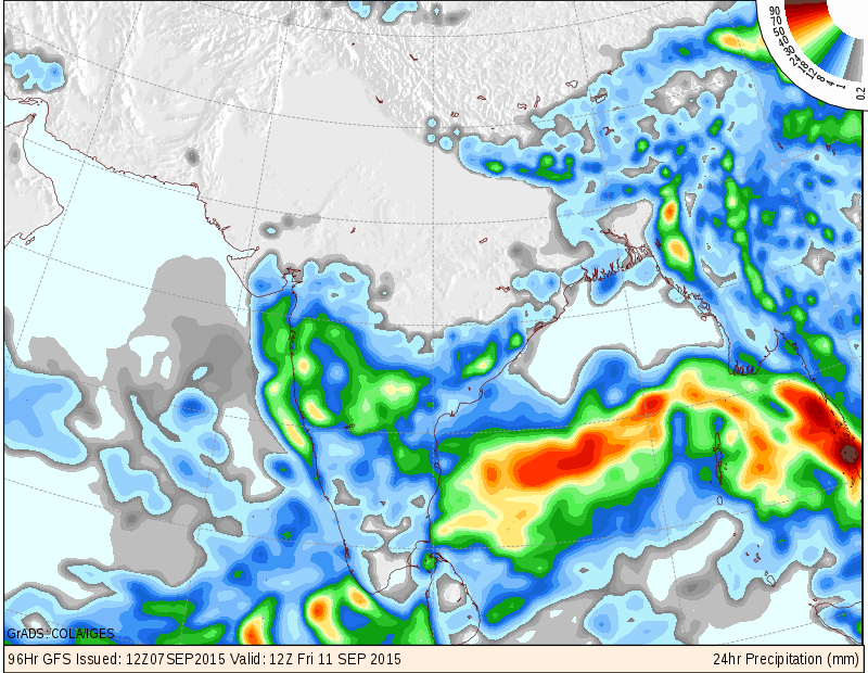
COLA/IGES Forecast Precipitation Valid for 12 UTC 11-09-2015
COLA/IGES Forecast Precipitation Valid for 12 UTC 12-09-2015
તારીખ 8 સપ્ટેમ્બર 2015 સવારે 8.00 વાગ્યે
1.5 કિમી ના લેવલે એક ટ્રફ મરાઠવાડા થી લક્ષદ્વીપ સુધી લંબાય છે.
એક UAC મધ્ય પશ્ચિમ બંગાળ ની ખાડી માં 1.5 કિમી થી 3.1 કિમી ના લેવલે છે.
એક UAC દક્ષીણ પાકિસ્તાન અને લાગુ વિસ્તાર ઉપર 1.5 કિમી થી 3.1 કિમી ના લેવલે છે.
વેસ્ટર્ન ડીસ્ટર્બન્સ હાલ પશ્ચિમી પવન ના અપર એર ટ્રફ તરીખે 73 ડિગ્રી E. અને 30 ડીગ્રી N. ઉપર છે.
સૌરાષ્ટ્ર અને ગુજરાત :
તારીખ 8 સપટેમ્બર થી 13 સપટેમ્બર 2015
અમૂક વિસ્તાર માં હળવો મધ્યમ વરસાદ પડેલ તેમજ અમૂક જગ્યાએ ઝાપટા પડેલ છે. તારીખ 8 થી 13 સપટેમ્બર સુધી અંશત વાદળ છાયું વાતાવરણ રહેશે. આગાહી સમય માં અમૂક દિવસે ઝાપટા/હળવો વરસાદ ની શક્યતા છે જેમાં સીમિત વિસ્તાર માં ક્યાંક ક્યાંક મધ્યમ વરસાદ પણ પડી શકે છે. આ પહેલાની આગાહી કરતા વરસાદ ની માત્રા વધુ રહેશે. તારીખ 8, 11 અને 12 સપ્ટેમબર માટે IMD તેમજ COLA/IGES ના નકશા આપેલ છે.
કચ્છ: આગાહી સમય માં કચ્છ માં ખાસ કઈ વરસાદ ની શક્યતા નથી અથવા ઓછી.
સૌરાષ્ટ્ર, ગુજરાત અને કચ્છ માટે ચોમાસું હજુ પૂરું નથી થયું.
નોંધ: અહી આગોતરું એંધાણ નીચે આપેલ છે જેની વિશ્વનીયતા 50 થી 70 ટકા સમજવી.
આગાહી સમય પછી બંગાળની ખાડી માં મજબૂત લો પ્રેસર ની શક્યતા.