Current Weather Conditions on 12th September 2016
A Low Pressure area has developed over Westcentral Bay of Bengal & adjoining coastal areas of South Odisha & North Coastal Andhra Pradesh. The associated Upper Air Cyclonic Circulation extending up to Mid-tropospheric levels tilting Southwards with height.
The Axis of Monsoon trough at mean sea level passes through Jammu, Una, Bareilly, Kanpur, Sidhi, Pendra, Bhawanipatna, Center of Low Pressure area and thence East Southeastwards to North Andaman sea.
The Upper Air Cyclonic Circulation over South Pakistan & adjoining Southwest Rajasthan between 1.5 & 3.1 km above mean sea level persists.
The Western Disturbance as an Upper Air Cyclonic Circulation from North Pakistan is now over Jammu & Kashmir and neighborhood between 3.1 & 5.8 km above mean sea level.
The Bay of Bengal Low Pressure Area is expected to remain in that area for next two three days.
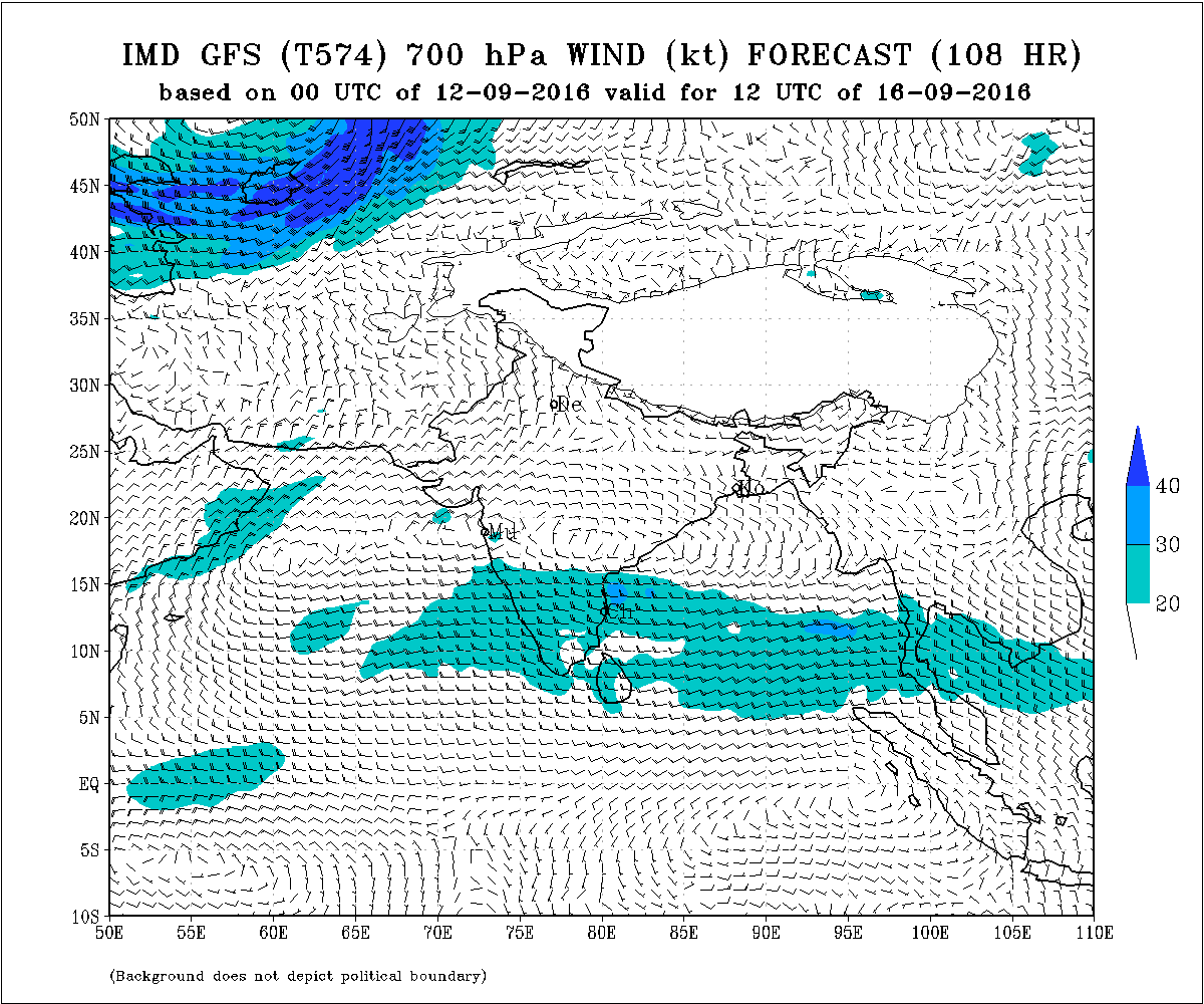
IMD GFS 700 hPa WInd Forecast Chart Valid for 12 UTC 16th September 2016
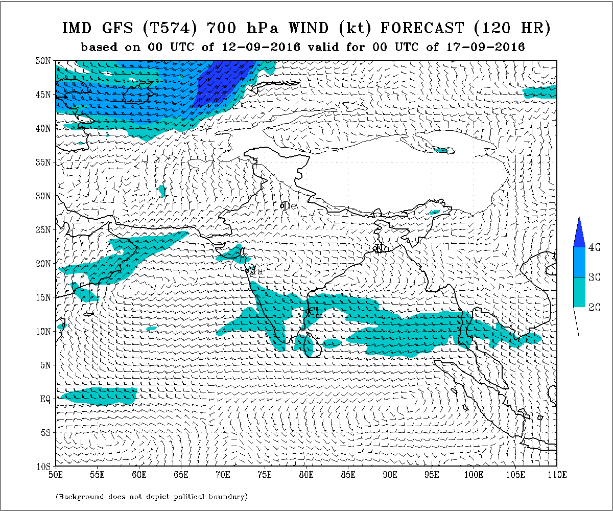
IMD GFS 700 hPa WInd Forecast Chart Valid for 00 UTC 17th September 2016
Forecast: 13th September to 19th September 2016
Rainfall expected from around 14th September.
Southeast Saurashtra : Light to medium & up to heavy rain total and during the forecast period.
( Southeast Saurashtra mainly Districts of Bhavnagar, Amreli, Somnath, Junagadh, Botad and adjoining areas)
Northwest & Central Saurashtra : Scattered Light to medium rain total during the forecast period.
Kutch : Scattered showers to Light rain total during the forecast period.
North Gujarat : Light to medium rain total during the forecast period.
East Central Gujarat : Medium to heavy rain total during the forecast period.
South Gujarat : Medium to heavy rain total with some very heavy rain total during the forecast period.
12 સપ્ટેમ્બર 2016 :
મધ્ય પશ્ચિમ બંગાળ ની ખાડી માં લો પ્રેસર દક્ષિણ ઓડિશા અને ઉત્તર આંધ્ર કિનારા પાસે થયું છે.
ચોમાસુ ધરી જમ્મુ, બરેલી, કાનપુર, ભવાનીપટનામ અને લો પ્રેસર સેન્ટર અને ત્યાં થી ઉત્તર આંદામાન ના દરિયા સુધી લંબાય છે.
એક યુએસી દક્ષિણ પાકિસ્તાન અને લાગુ દક્ષિણ રાજસ્થાન ઉપર છે.
વેસ્ટર્ન ડિસ્ટર્બન્સ 3.1 કિમિ થી 5.8 કિમિ ના યુએસી તરીકે ઉત્તર પાકિસ્તાન થી હવેય જમ્મુ અને કાશ્મીર ઉપર આવેલ છે.
બંગાળ ની ખાડી વાળું લો પ્રેસર હજુ બે ત્રણ દિવસ તે વિસ્તાર માં રહેશે.
આગાહી: 13 થી 19 સપ્ટેમ્બર 2016
14 સપ્ટેમ્બર થી વરસાદ ચાલુ થાય તેવી શક્યતા છે.
દક્ષિણ પૂર્વ સૌરાષ્ટ્ર : આગાહી સમય દર્મિયાન નો કૂલ વરસાદ મધ્યમ અને સીમિત વિસ્તારો માં ભારે સુધી ની માત્રા ની શક્યતા છે.
(દક્ષિણ પૂર્વ સૌરાષ્ટ્ર માં જીલ્લાઓ મુખ્યત્વે ભાવનગર, અમરેલી, સોમનાથ, જૂનાગઢ, બોટાદ અને લાગુ વિસ્તારો )
બાકી સૌરાષ્ટ્ર : આગાહી સમય દર્મિયાન નો કૂલ વરસાદ હળવો અને સીમિત વિસ્તારમાં મધ્યમ સુધી ની માત્રા ની શક્યતા છે.
કચ્છ : આગાહી સમય દર્મિયાન ઝાપટા થી હળવો વરસાદ ની માત્રા ની શક્યતા છે.
ઉત્તર ગુજરાત : આગાહી સમય દર્મિયાન નો કૂલ વરસાદ હળવો થી મધ્યમ સુધી ની માત્રા ની શક્યતા છે.
મધ્ય પૂર્વ ગુજરાત : આગાહી સમય દર્મિયાન નો કૂલ વરસાદ મધ્યમ થી ભારે સુધી ની માત્રા ની શક્યતા છે.
દક્ષિણ ગુજરાત : આગાહી સમય દર્મિયાન નો કૂલ વરસાદ મધ્યમ થી ભારે સુધી ની માત્રા ની શક્યતા છે અને અમૂક વિસ્તાર માં અતિ ભારે સુધી ની માત્રા ની શક્યતા છે.
Caution: Please refer/rely on IMD/RSMC Bulletins/Advisories for Storms & Weather related matter.
Please follow these guidelines or else comment facility will be disabled for some time.
Guideline for Comments:
1. Please post comment if you have a valid email address.
2. Read earlier comments and their reply before posting any comment.
3. Do not ask question about when the update will take place. Usually as and when deemed fit update will be given.
4. I do not forecast for long term, so do not ask for any forecast beyond 7 days.
5. Do not ask when it will rain in any city, town or village or city. Normally the forecast is given for broad areas of Saurashtra, Kutch & Gujarat. However, for your information Multicity Wunderground Forecast link has been provided for various centers of Gujarat, Sayrashtra & Kutch.
6. All Comments will not be answered. Comments that is meant for larger audience is preferable and will be answered.
7. Please do not repeat your comment if the comment is in moderation (answer pending ).
સાવચેતી:
સ્ટોર્મ કે હવામાન અંગે ની માહિતી માટે ભારતીય હવામાન ખાતા/ગવર્મેન્ટ ના બુલેટીન/સુચના પર નિર્ભર રહેવું.
કમેન્ટ માટે માર્ગદર્શન:
કમેન્ટ અંગે ના માર્ગદર્શન નો અમલ કરો નહીંતર ના છૂટકે કમેન્ટ વ્યવસ્થા હાલ પૂરતી બંધ કરવા માં આવશે.
1. ખરું ઈ મેઈલ એડ્રેસ હોઈ તો કમેન્ટ કરો.
2. આગળ સવાલો અને તેના જવાબ વાંચી ને તમારી કમેન્ટ કરો.
3. “અપડેટ ક્યારે થશે ?” તેવા સવાલ કરવા નહિ. સામાન્ય રીતે યોગ્ય લાગશે ત્યારે અપડેટ થશે.
4. હું લાંબા ગાળા ની આગાહી નથી કરતો માટે 7 દિવસ થી આગળ માટે આગાહી બાબત કમેન્ટ ના કરવી.
5. “મારા શહેર, કે ગામ માં વરસાદ ક્યારે થશે ?” તેવા સવાલ પૂછવા નહિ. સામાન્ય રીતે સૌરાષ્ટ્ર, ગુજરાત અને કચ્છ ના બહોળા વિસ્તારો ની આગાહી આપેલ હોઈ છે. તમારા વિસ્તાર ના મોટા સેન્ટર માટે વંડરગ્રાઉન્ડ ની આગાહી ની લિન્ક આપેલ છે અહીં મેનુ માં.
6. જે કમેન્ટ વધુ લોકો ને સ્પર્શતો હોઈ તે આવકાર્ય છે અને તેના યોગ્ય જવાબ મળશે. બધા કમેન્ટ નો જવાબ નહીં મળે.
7. કમેન્ટ મોડરેશન (જવાબ પેન્ડિંગ ) હોઈ બીજી વાર પૂછવું નહીં.
Weather Forecast In Akila Daily Dated 22nd August 2016