Current Weather Conditions on 16th April 2017 @ 12.30 pm. IST
મારુથા વાવાઝોડું મધ્ય પૂર્વ બંગાળ ની ખા માં છે – આજે રાત્રી ના મ્યાનમાર માં પહોંચશે – 16 એપ્રિલ 2017
INDIA METEOROLOGICAL DEPARTMENT
Bulletin No.: 9 (BOB 01/2017)
Sub: Cyclonic Storm (Maarutha) over East Central Bay of Bengal
Time of issue: 1100 hours IST
Dated: 16.04.2017
Sub: Cyclonic Storm (Maarutha) over eastcentral Bay of Bengal
The cyclonic storm (Maarutha) over eastcentral Bay of Bengal further moved northeastwards with a speed of 32 kmph during past 06 hours and lay centred at 0830 hrs IST of today, the 16 th April, 2017 over eastcentral Bay of Bengal near Latitude 16.7º N and Longitude 92.5ºE, about 420 km nearly north of Maya Bandar (Andaman & Nicobar Islands) and 280 km southwest of Sandoway (Myanmar). The system is likely to move northeastwards and cross Myanmar coast near Sandoway around mid-night of today, the 16 th April 2017.
The details available here IMD Bulletin No.: 9 (Nine)
INDIA METEOROLOGICAL DEPARTMENT
Bulletin No.: 8 (BOB 01/2017)
Sub: Cyclonic Storm (Maarutha) over East Central Bay of Bengal
Time of issue: 0830 hours IST
Dated: 16.04.2017
The details of earlier Bulletin is available here IMD Bulletin No.: 8 (Eight)
1 knot= 1.85 km./hour
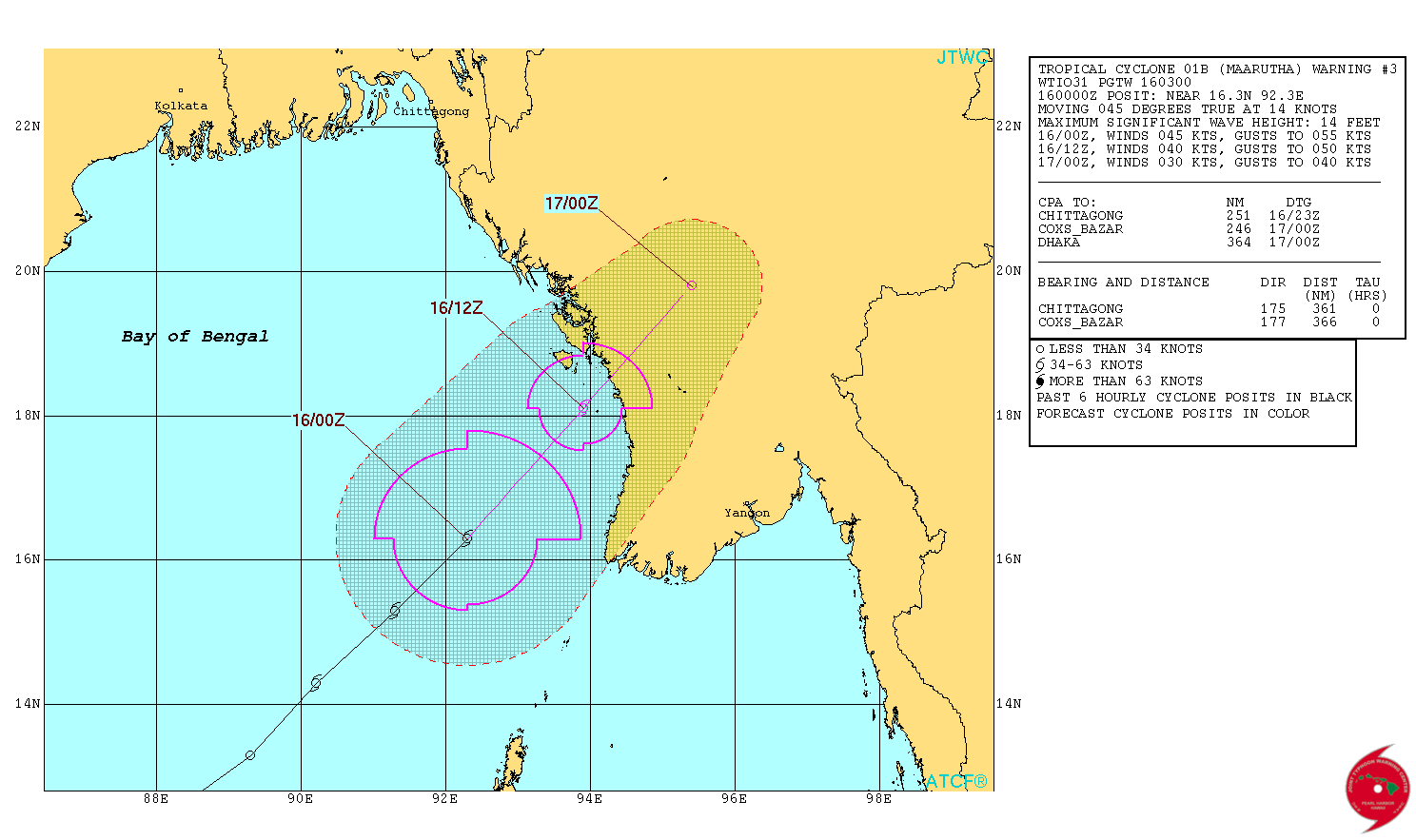
JTWC Tropical Cyclone 01B MAARUTHA ( Cyclonic Storm “MAARUTHA”) Warning No. 3
Issued at 0300 UTC on 16th April 2017
NRL IR Satellite Image of 01B.MAARUTHA (Cyclonic Storm “MAARUTHA”)
on 16th April 2017 @ 0600 UTC (11.30 am. IST)

| UW-CIMSS Automated Satellite-Based Advanced Dvorak Technique (ADT) Version 8.2.1 Tropical Cyclone Intensity Estimation Algorithm |
|
| Current Intensity Analysis | |
                     UW - CIMSS
              ADVANCED DVORAK TECHNIQUE
                  ADT-Version 8.2.1
         Tropical Cyclone Intensity Algorithm

             ----- Current Analysis -----
     Date :  16 APR 2017    Time :   050000 UTC
      Lat :   17:06:35 N     Lon :   92:58:04 E


                CI# /Pressure/ Vmax
                3.3 / 991.3mb/ 51.0kt


             Final T#  Adj T#  Raw T#
                3.3     3.5     3.5

 Center Temp : -58.0C    Cloud Region Temp : -59.2C

 Scene Type : IRREGULAR CDO*

 Positioning Method : FORECAST INTERPOLATION

 Ocean Basin : INDIAN
 Dvorak CI > MSLP Conversion Used : CKZ Method

 Tno/CI Rules : Constraint Limits : NO LIMIT
                   Weakening Flag : OFF
           Rapid Dissipation Flag : OFF

 C/K/Z MSLP Estimate Inputs :
  - Average 34 knot radii :   70km
  - Environmental MSLP    : 1006mb

 Satellite Name :   HIM-8
 Satellite Viewing Angle : 57.6 degrees

****************************************************
|
Estimate:
Distance of the Cyclonic Storm is around 250 kms. at 0500 UTC (10.30 am. IST) as per UW-CIMSS for landfall over Myanmar.
Caution: Please refer/rely on IMD/RSMC Bulletins/Advisories for Storms & Weather related matter.
સાવચેતી:
સ્ટોર્મ કે હવામાન અંગે ની માહિતી માટે ભારતીય હવામાન ખાતા/ગવર્મેન્ટ ના બુલેટીન/સુચના પર નિર્ભર રહેવું.