10th June 2019 @ 10.00 pm Update
Deep Depression over Eastcentral & adjoining Southeast Arabian Sea: Cyclone Alert for Gujarat Coast:
Yellow Message
IMD BULLETIN NO. : 04 (ARB/01/2019)
TIME OF ISSUE: 2100 HOURS IST DATED: 10.06.2019
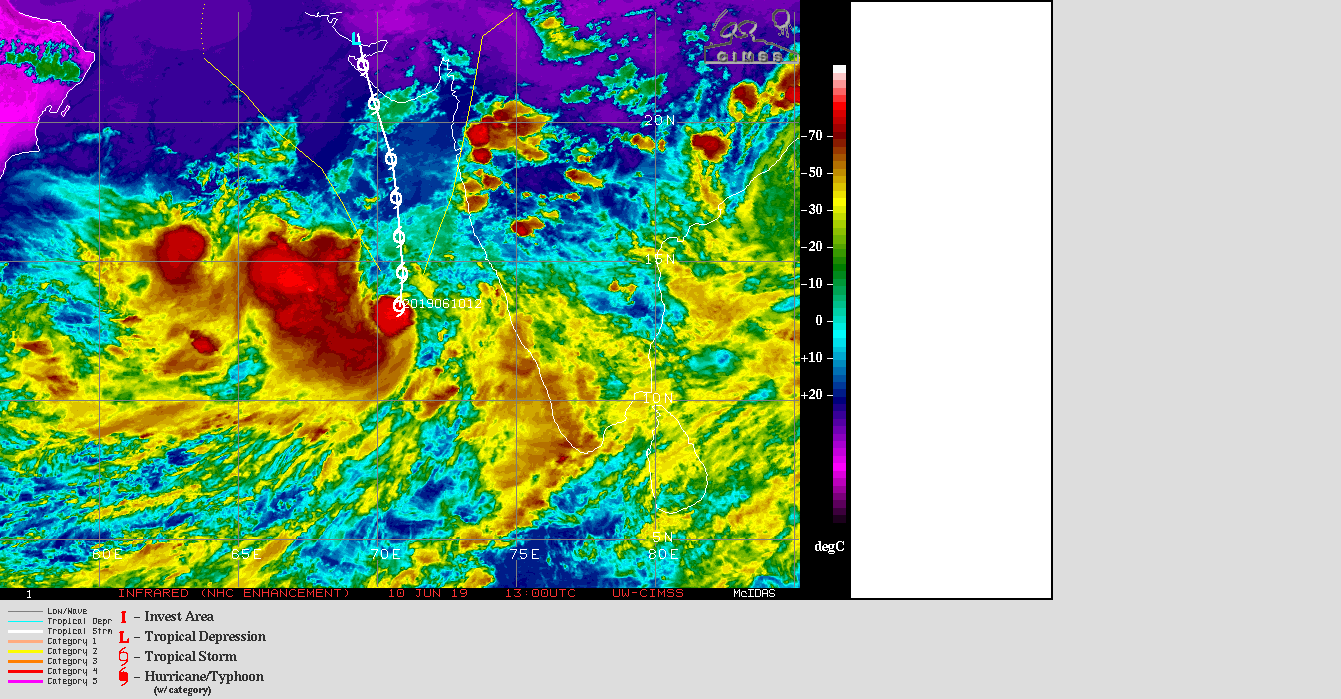
A Low Pressure had developed over Southeast Arabian Sea on 9th June morning and it became Well Marked same evening and concentrated into a Depression 10th June morning and Deep Depression by evening. JTWC has already issued Tropical Cyclone Warning No. 1. The wind speed on International scales is 35 knots ( 65 kms/hour on 1 minute average wind speeds basis. IMD has a 3 minutes average basis). The Central pressure reported is 996 millibars. Location of the System is Lat. 13.4N & Long. 70.8E at 05.30 pm IST on 10th June 2019.
તારીખ 9 જૂન સવાર ના દક્ષિણ પૂર્વ અરબી સમુદ્ર માં એક લો પ્રેસર થયું હતું જે સાંજે વેલ માર્કંડ થયું. આજે સવારે આ સિસ્ટમ વધુ મજબૂત બની ડિપ્રેસન માં પરિવર્તિત થઇ અને સાંજે ડીપ ડિપ્રેસન થયું।. પવન 65 કિમિ પ્રતિ કલાક છે. (1 મિનિટ ની શરેરાશ મુજબ. IMD માં 3 મિનિટ ની શરેરાશ મુજબ હોય છે ) સિસ્ટમ નું પ્રેસર 996 મિલીબાર છે અને લોકેશન 13.4N અને 70.8E છે આજે સાંજે 05.30 વાગ્યે 10 જૂન 2019 ના .
JTWC Tropical Cyclone 02A.TWO Warning No. 1 ( Potential Cyclonic Storm “VAYU”)
Dated 10th June 2019 @ 1500 UTC (10th June 08.30 pm IST)

UW CIMMS Tropical Cyclone Tracker 02A.TWO (Potential Tropical Cyclone “VAYU”) IR Satellite Image
On 10th June 2019 @1300 UTC
NRL IR Satellite Image 02A.TWO (Potential Cyclonic Storm “VAYU”) Dated 10th June 2019 @ 1400UTC

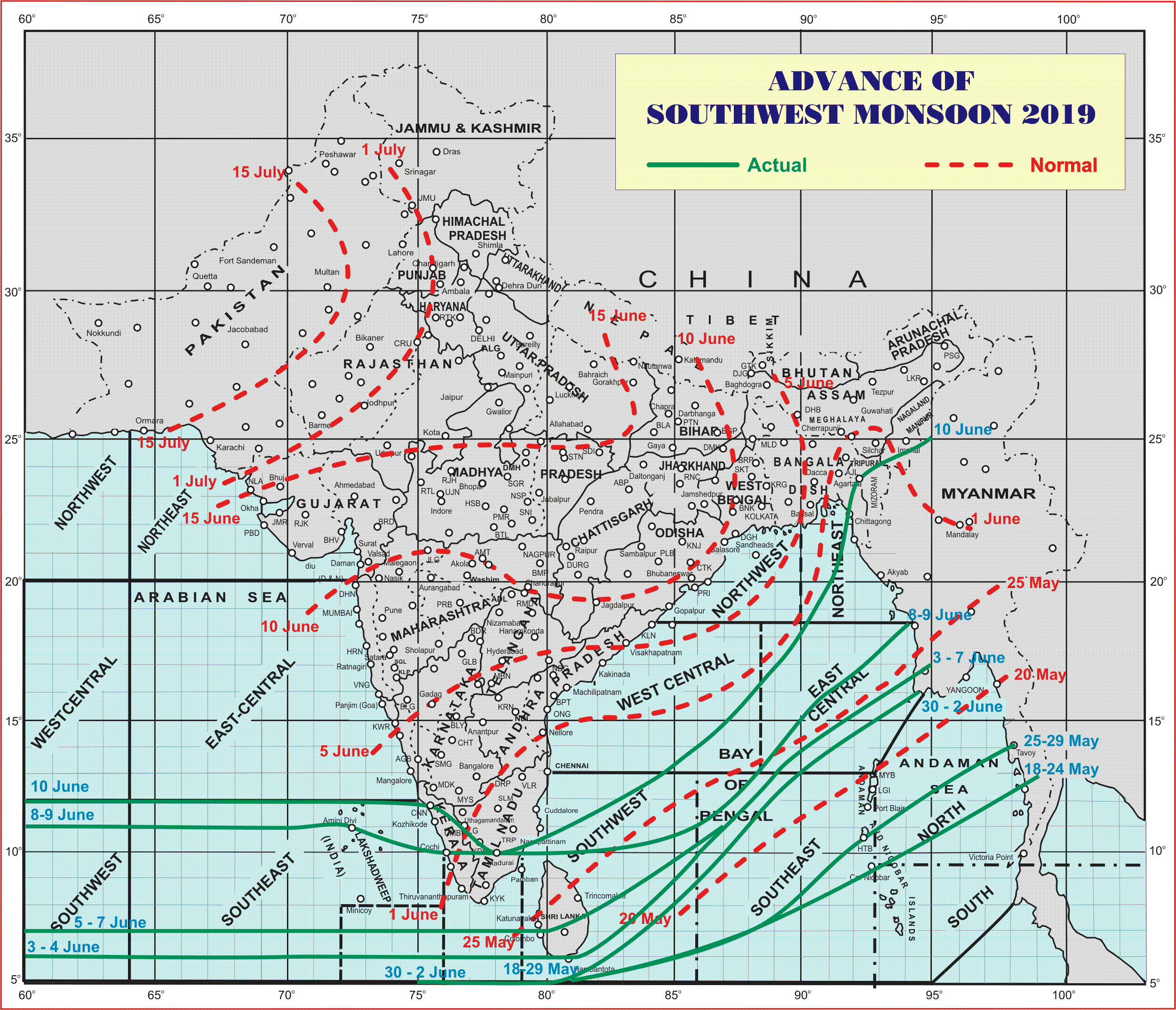
સૌથી ઉપર ની લીલી લીટી ના છેડે જે તારીખ હોઈ તે તારીખે લીટી ની નીચે ના ભાગ માં બધે ચોમાસું પોંચી ગયું છે તેમ સમજવું.
લાલ ત્રુટક લીટી જે તે વિસ્તાર માં નોર્મલ ચોમાસું બેસવાની તારીખ દર્શાવે છે
The date shown at the end of green line shows that the Southwest Monsoon has set in over areas below the green line on that date.
The red dashed line shows the normal date of onset of Southwest Monsoon over various regions
For specific locations forecast please use this link or any other forecast model to see weather for your location.
https://meteologix.com/in
જુદા જુદા સેન્ટર માટે ની આગાહી માટે આ લિંક માં તમારા સેન્ટર નું નામ નાખી આગાહી જોય લેવાની અથવા બીજા કોઈ પણ ફોરકાસ્ટ મોડલ નો ઉપયોગ કરો.
Forecast: Saurashtra, Gujarat & Kutch 10th To 15th June 2019
The Deep Depression System over is now over East Central Arabian Sea and is expected to strengthen further to a Cyclonic Storm within 12 hours and track mainly Northerly direction during the next two days. Since the System is expected to track towards Saurrashtra coast, there is all likely hood of high winds accompanied with extremely high rainfall in the Coastal areas of Saurashtra & Kutch during 12th to 15th June.
અપડેટ:
સૌરાષ્ટ્ર, ગુજરાત અને કચ્છ: તારીખ 10 થી 15 જૂન 2019
ડીપ ડિપ્રેસન સિસ્ટમ હવે મધ્ય પૂર્વ અરબી સમુદ્ર ઉપર આવી છે અને આવતા 12 કલાક માં હજુ વધુ મજબૂત બની વાવાઝોડા માં પરિવર્તિત થશે એન્ડ મુખ્યત્વે શરૂવાત માં ઉત્તર બાજુ ગતિ કરશે અને ત્યાર બાદ ઉત્તર ઉત્તર પશ્ચિમ બાજુ ગતિ કરશે।. સિસ્ટમ સૌરાષ્ટ્ર તરફ આવતી હોય સૌરાષ્ટ્ર ના દરિયાપટ્ટી ના જિલ્લાઓ માં વધુ પવન અને સાથે અતિ ભારે વરસાદ પાડવાની સંભાવના છે માટે સાવચેત રહેવું તારીખ 12 જૂન થી 15 જૂન 2019.
Caution: Please refer/rely on IMD/RSMC Bulletins/Advisories for Storms & Weather related matter.
સાવચેતી: સ્ટોર્મ કે હવામાન અંગે ની માહિતી માટે ભારતીય હવામાન ખાતા/ગવર્મેન્ટ ના બુલેટીન/સુચના પર નિર્ભર રહેવું.

