Current Weather Conditions on 6th November @ 8.00 am. IST
Observations:
The Cyclonic Storm “MEGH” is now over Westcentral Arabian Sea. As per International Weather Agencies the winds are blowing at 75 km./hour with gusts of 95 km/hour based on average winds on 1 minute basis as compared to IMD’s basis of 3 minute average wind speed. The System is expected to track towards Socotra Island, Yemen next few days. The System expected to strengthen further to a Severe Cyclonic Storm during the next 24 hours as per IMD/RSMC norms.
Under the influence of UAC over South Bay of Bengal a Low Pressure area has developed over Southeast Bay of Bengal. This System is being monitored as 96B.INVEST.
The Western Disturbance as an Upper Air Cyclonic Circulation over Jammu & Kashmir and adjoining North Pakistan extending up to 3.1 km above mean with a trough aloft roughly along Long. 72.0°E and North of Lat. 30.0°N persists. The induced UAC over Punjab & neighborhood extending up to 1.5 km above mean sea level also persists.
Another Western Disturbance would affect Western Himalayan region from 8th November.
TROPICAL CYCLONE ADVISORY RSMC – TROPICAL CYCLONES, NEW DELHI TROPICAL STORM ‘MEGH’ ADVISORY NO. FOUR ISSUED AT 0000 UTC OF 6 TH NOVEMBER 2015 BASED ON 2100 UTC CHARTS OF 5TH NOVEMBER 2015.
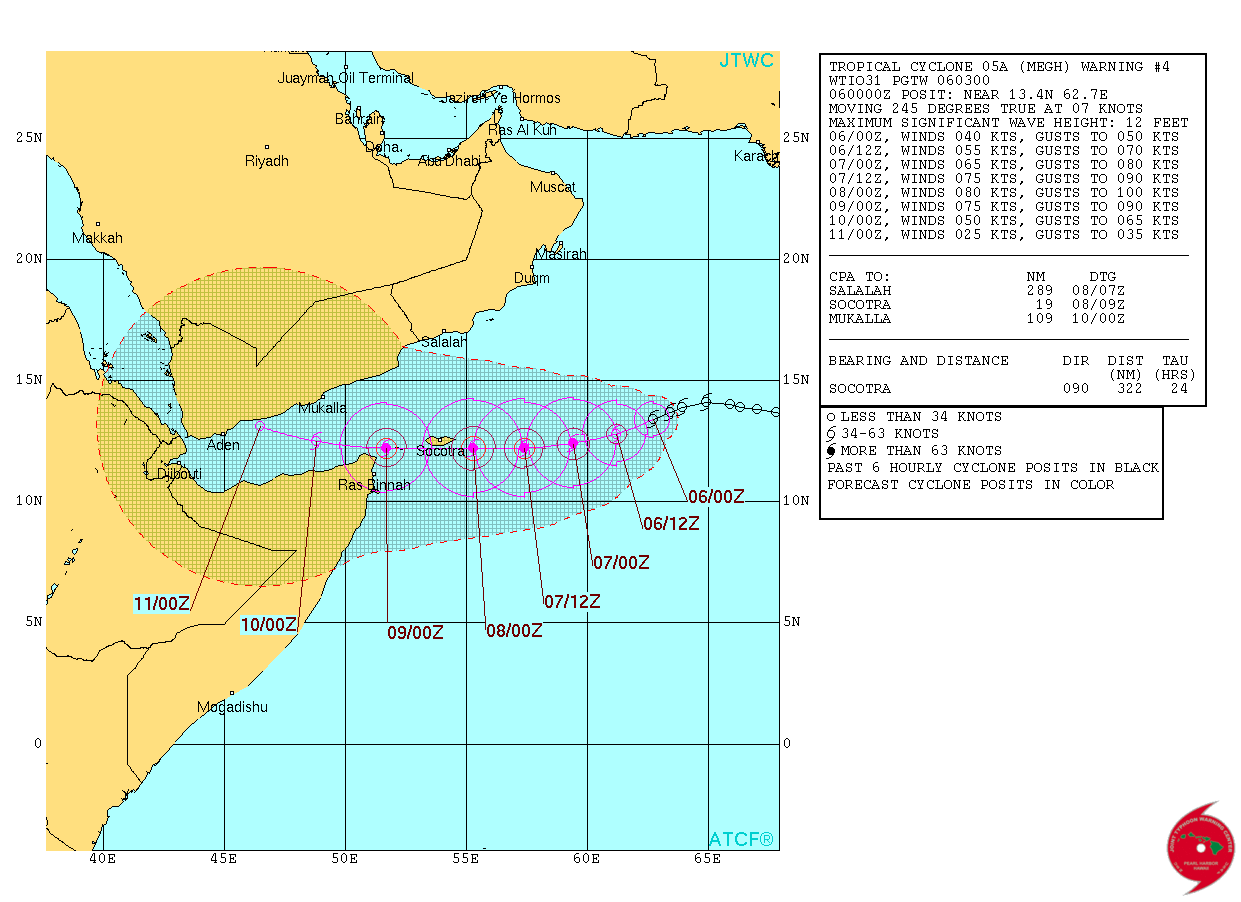
THE CYCLONIC STORM ‘MEGH’ OVER WESTCENTRAL ARABIAN SEA MOVED WESTSOUTHWESTWARDS AT A SPEED OF 11 KMPH IN PAST SIX HOURS AND LAY CENTRED AT 2100 UTC OF TODAY THE 5 TH NOVEMBER 2015 NEAR LATITUDE 13.8 0 N AND LONGITUDE 63.1 0 E, ABOUT 1190 KM SOUTHWEST OF MUMBAI (43003) AND 1040 KM EAST-SOUTHEAST OF SALALAH (41316), OMAN. IT WOULD MOVE WEST-SOUTHWESTWARDS AND INTENSIFY INTO A SEVERE CYCLONIC STORM DURING NEXT 24 HRS. IT WOULD CONTINUE TO MOVE WEST-SOUTHWESTWARDS TOWARDS GULF OF ADEN.
ACCORDING TO SATELLITE IMAGERY, INTENSITY IS T 2.5. MAXIMUM SUSTAINED SURFACE WIND SPEED IS 40 KNOTS GUSTING TO 50 KNOTS. THE ESTIMATED CENTRAL PRESSURE IS ABOUT 998 HPA. STATE OF SEA AROUND SYTEM CENTRE IS HIGH. ASSOCIATED BROKEN LOW AND MEDIUM CLOUDS WITH EMBEDDED MODERATE TO INTENSE CONVECTION OVER AREA BETWEEN LATITUDE 12.0 DEGREE NORTH TO 17.0 DEGREE NORTH AND LONGITUDE 61.0 DEGREE EAST TO 65.0 DEGREE EAST. MINIMUM CTT IS -72 0cC, THE CLOUD SHOWS CURVED BAND PATTERN.
JTWC Tropical Cyclone 05A (Five) Warning #04
on 6th Nov. 2015 @ 0300 UTC
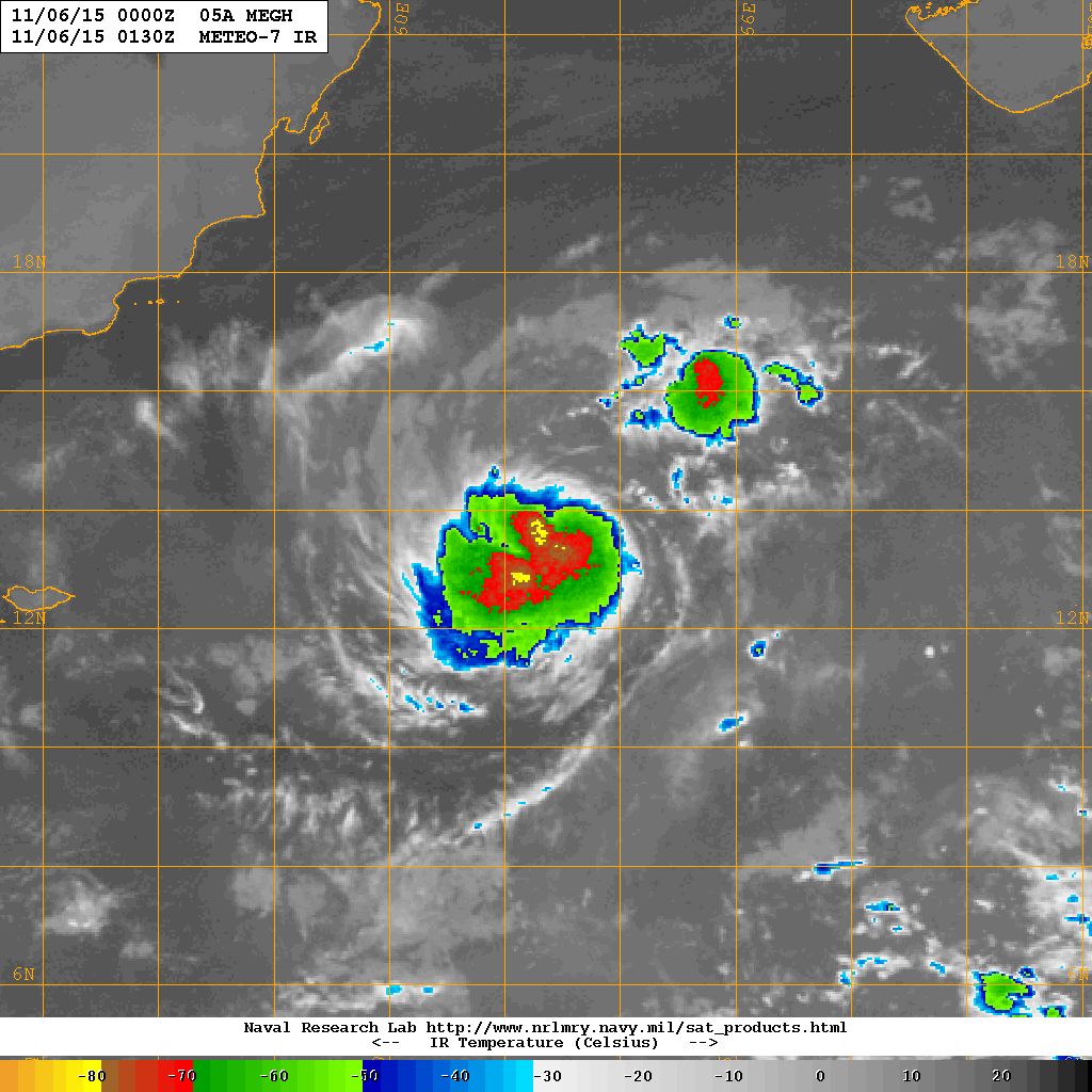
05A.MEGH Now Over Central Arabian Sea Location 13.4 N. & 62.7 E. with winds of 40 knots with 993 millibar Central Pressure on 6th November NRL IR Satellite Image @ 0130 UTC
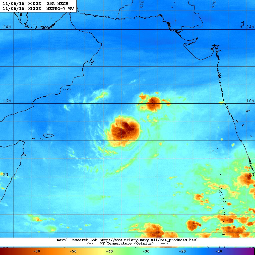
05A.MEGH Now Over Central Arabian Sea Location 13.4 N. & 62.7 E. with winds of 40 knots with 993 millibar Central Pressure on 6th November NRL Water Vapor Satellite Image @ 0130 UTC
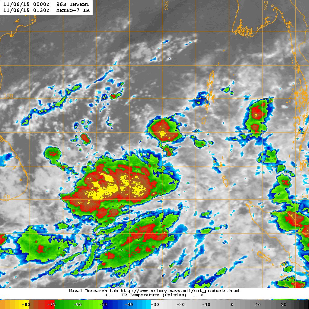
96B.INVEST Over Southeast Bay of Bengal Location 8.7 N. & 89.5 E. with winds of 20 knots with 1007 millibar Central Pressure on 6th November NRL IR Satellite Image @ 0130 UTC
Forecast for Saurashtra, Gujarat & Kutch: 6th to 12th November 2015
Cyclonic Storm “MEGH” will not affect Saurashtra, Gujarat & Kutch since the System is tracking Westwards away from India.
Forecast models indicates that the Bay of Bengal System is expected to cross over to the Arabian Sea and is not expected to affect Saurashtra, Gujarat & Kutch during the forecast period.
The Maximum and Minimum Temperature over most parts of Saurashtra, Gujarat & Kutch will be normal or slightly above normal. The weather is expected to be dry with winds mainly from North/Northeast during the forecast period.
Advance Indications: If the Bay of Bengal System (96B.INVEST ) crosses over to Arabian Sea, there is 50% chance of unseasonal rain over Saurashtra, Gujarat & Kutch after the end of current forecast period (meaning after 12th November).
Caution: Please refer/rely on IMD/RSMC Bulletins/Advisories for Storms & Weather related matter.
અપડેટ તારીખ 6 નવેમ્બર 2015 સવારે 8.00 કલાકે:
અરબી સમુદ્ર માં જે વાવાઝોડું “MEGH” છે તેના પવનો ઇન્ટરનેસનલ એજન્સી મૂજબ 75 કિમી પ્રતિ કલાકે ફૂંકાય છે (1 મિનીટ ની શરેરાશ મૂજબ ) જે IMD 3 મિનીટ ની શરેરાશ મૂજબ માપે છે. આંચકા ના પવનો 95 કિમી ની ઝડપે ફૂંકાય છે (1 મિનીટ ની શરેરાશ મૂજબ ). અરબી સમુદ્ર ની સીસ્ટમ હાલ યેમેન ના સોકોટ્રા ટાપુ તરફ તરફ જાય છે અને 24 કલાક માં હજુ મજબૂત થશે. સીસ્ટમ સૌરાષ્ટ્ર તેમજ ગુજરાત થી દૂર જાય છે.
દક્ષીણ બંગાળી ખાડી માં UAC હતું તેની અસર થી દક્ષીણ પૂર્વ બંગાળ ની ખાડી માં લો પ્રેસર થયું છે.
જમ્મુ કાશ્મીર ઉપર વેસ્ટર્ન ડીસ્ટર્બન્સ 3.1 કિમી ની ઉંચાયે UAC તરીકે છે જેનો ટ્રફ 72.0°E and North of Lat. 30.0°N. છે. એની અસર થી પંજાબ ઉપર 1.5 કિમી ની ઊંચાયે UAC થયું.
તારીખ 8 નવેમ્બર ના નવું વેસ્ટર્ન ડીસ્ટર્બન્સ પશ્ચિમ હિમાલય માં છવાશે.
સૌરાષ્ટ્ર, કચ્છ અને ગુજરાત: 6 નવેમ્બર થી 12 નવેમ્બર 2015
મધ્ય પશ્ચિમ અરબી સમુદ્ર નું વાવાઝોડું “મેઘ” સૌરાષ્ટ્ર, ગુજરાત અને કચ્છ ને અસર નહિ કરે કારણ કે તે પશ્ચિમ તરફ ગતિ કરશે અને ભારત થી દૂર જશે.
ફોરકાસ્ટ મોડલ મૂજબ આગાહી સમય માં બંગાળની સીસ્ટમ અરબી સમુદ્ર બાજુ આવે તેવી શક્યતા છે પણ આગાહી સમય માં સૌરાષ્ટ્ર, ગુજરાત અને કચ્છ ને અસર નહિ કરે.
મહત્તમ અને ન્યુનત્તમ તાપમાન માં વધારો થયો છે અને હવે નોર્મલ અથવા નોર્મલ થી થોડું ઊંચું થયું છે. આગાહી સમય માં આમજ રહેશે અને વાતાવરણ સુકું રહેશે તેમજ પવનો મુખ્યત્વે ઊત્તર અને ઊત્તર પૂર્વ ના રહેશે.
આગોતરું એંધાણ: બંગાળની ખાડી ની સીસ્ટમ જો અરબી સમુદ્ર બાજુ આવે તો તારીખ 12 પછી સૌરાષ્ટ્ર, ગુજરાત અને કચ્છ માં માવઠા ની 50% શક્યતા ગણવી.
સાવચેતી:
સ્ટોર્મ કે હવામાન અંગે ની માહિતી માટે ભારતીય હવામાન ખાતા/ગવર્મેન્ટ ના બુલેટીન/સુચના પર નિર્ભર રહેવું.
Weather Forecasat in Akila Daily Dated 6th November 2015
Naliya ma chhe thandi…. baaki koi center ma nathi. Badhe normal chhe. Rajkot Min. 18.7 C chhe te normal chhe haal maate.
jigar
07/11/2015 8:29 pm
Hello sir
perception after 4 days in all site uk weather and perception outlook of india no clouds in guj. Clouds and all are near by gujarat…i think now this system will come clouser but will not effect guj by seeing all sites from today.what u say sir.
Etle ene aagahi nathi kidhi…. ane te pan 50% kahel chhe……fakt kheduo ne sajaag raheva maate chhe.
abizer kachwala
07/11/2015 4:38 pm
ashok sir, i am the resident of raigad in konkan and the regular follower of blog. as there are 50 percent chances of rain in saurashtra .what would you tell about konkan .please answer my question even if it is a short term one
Tamara comment babat reply bija vachak ne apel chhe.
jigar
06/11/2015 1:58 pm
hello sir, I am continuosly watching two sites uk weather and perception outlook, its changing daily but outcome of last 3 days is same i mean system which ever comes is effecting western gujarat more like kutch dwarka jamnagar upto my city surendranagar and its not one day from 14 to 19 whole of 6 days yes rainfall according to images seems to be average i mean showers to medium rainfall max to 4 to 5inch at few places.. specially over kutch dwarka jamnagar and west saurashtra . still early days for this.. but as i am following u from… Read more »
Normally Arabian Sae ma chomasa pahela ane pachhi Low Pressure/Vavazoda banta hoi chhe.
Bangad ni khadi ma chomasama Low Pressure thata hoi chhe ane te Central India ane North India ne varsad ape chhe.
Chomasa pahela ane pachhi pan BOB ma Low Pressure banta hoi.
Banne baju na Dariya ma vadh ghat garmi hoi chhe.
Haal Arabian Baju garam chhe.
Te jova maate IOD jovu pade. ( Indian Ocean Dipole je haal Positive chhe… etle ke Arabian Sea garam chhe. 1st November IOD = 0.89)
Vipul sinojiya govindpar
06/11/2015 10:28 am
Sir advance indication mate aabhar
bhare munjavan ma mukaya
30 vigha ni magafali kal thi upadavi chhe
Vala Ajit
06/11/2015 9:06 am
Sir Bengal vari system effect kari sake? Saurashtra ne.
New update kale chhe ?
Tamoe ne samya sawal poochhel ane tamoe jawab deva ni kai darkar nathi kari !
Aje ekdam thandi khub chhe tenu su karan?
Kya center ni vaat karo chho ?
Naliya ma chhe thandi…. baaki koi center ma nathi. Badhe normal chhe. Rajkot Min. 18.7 C chhe te normal chhe haal maate.
Hello sir
perception after 4 days in all site uk weather and perception outlook of india no clouds in guj. Clouds and all are near by gujarat…i think now this system will come clouser but will not effect guj by seeing all sites from today.what u say sir.
I have already told you about pinch of salt. This is what I wanted to impress upon you. Monitoring continues….
Sir.aagotra andaj ma far far chhe haal
na vatavarn mujab mavthu nahi thay ?
fai pachad bhatriji.
Etle ene aagahi nathi kidhi…. ane te pan 50% kahel chhe……fakt kheduo ne sajaag raheva maate chhe.
ashok sir, i am the resident of raigad in konkan and the regular follower of blog. as there are 50 percent chances of rain in saurashtra .what would you tell about konkan .please answer my question even if it is a short term one
Raigad District is expected to get showers/light rain around 12th. This is not for one particular city but the District.
Sir bangal vali system ketluk jor karse? Dip dipressen sudhi these?
Update thaya karshe. Haju IMD moojab UAC chhe.
International Agenc pramane Low Pressure chhe.
IMD avati kaale Low Pressure declare karshe.
dear Shri Ashokbhai……khubaj Tuka gala ma Arbian Sea upar 02 vavazoda ( Chapla + MEGH ) create thaya. Jayare monsoon season ma avu thati nathi…. please detail ma explain kari sako ? please ? please ?
Tamara comment babat reply bija vachak ne apel chhe.
hello sir, I am continuosly watching two sites uk weather and perception outlook, its changing daily but outcome of last 3 days is same i mean system which ever comes is effecting western gujarat more like kutch dwarka jamnagar upto my city surendranagar and its not one day from 14 to 19 whole of 6 days yes rainfall according to images seems to be average i mean showers to medium rainfall max to 4 to 5inch at few places.. specially over kutch dwarka jamnagar and west saurashtra . still early days for this.. but as i am following u from… Read more »
My forecasts are written after reviewing all the forecast models available and I am aware of all the sources you are mentioning.
Sir.Bob vali system Jo saurashtra kutch & gujarat taraf aave to ketla divso ma ahi phonchi sake ??
System Saurashtra sudhi ponchi jashe evu kai kahel nathi.
Sir aa ek mahinama Arab Sagar ma 3 vavazoda sarjaya che. tenu su karan hoy sake?
Normally Arabian Sae ma chomasa pahela ane pachhi Low Pressure/Vavazoda banta hoi chhe.
Bangad ni khadi ma chomasama Low Pressure thata hoi chhe ane te Central India ane North India ne varsad ape chhe.
Chomasa pahela ane pachhi pan BOB ma Low Pressure banta hoi.
Banne baju na Dariya ma vadh ghat garmi hoi chhe.
Haal Arabian Baju garam chhe.
Te jova maate IOD jovu pade. ( Indian Ocean Dipole je haal Positive chhe… etle ke Arabian Sea garam chhe. 1st November IOD = 0.89)
Sir advance indication mate aabhar
bhare munjavan ma mukaya
30 vigha ni magafali kal thi upadavi chhe
Sir Bengal vari system effect kari sake? Saurashtra ne.
Gujarati ma lakhel chhe….. vancho.