26th May 2017
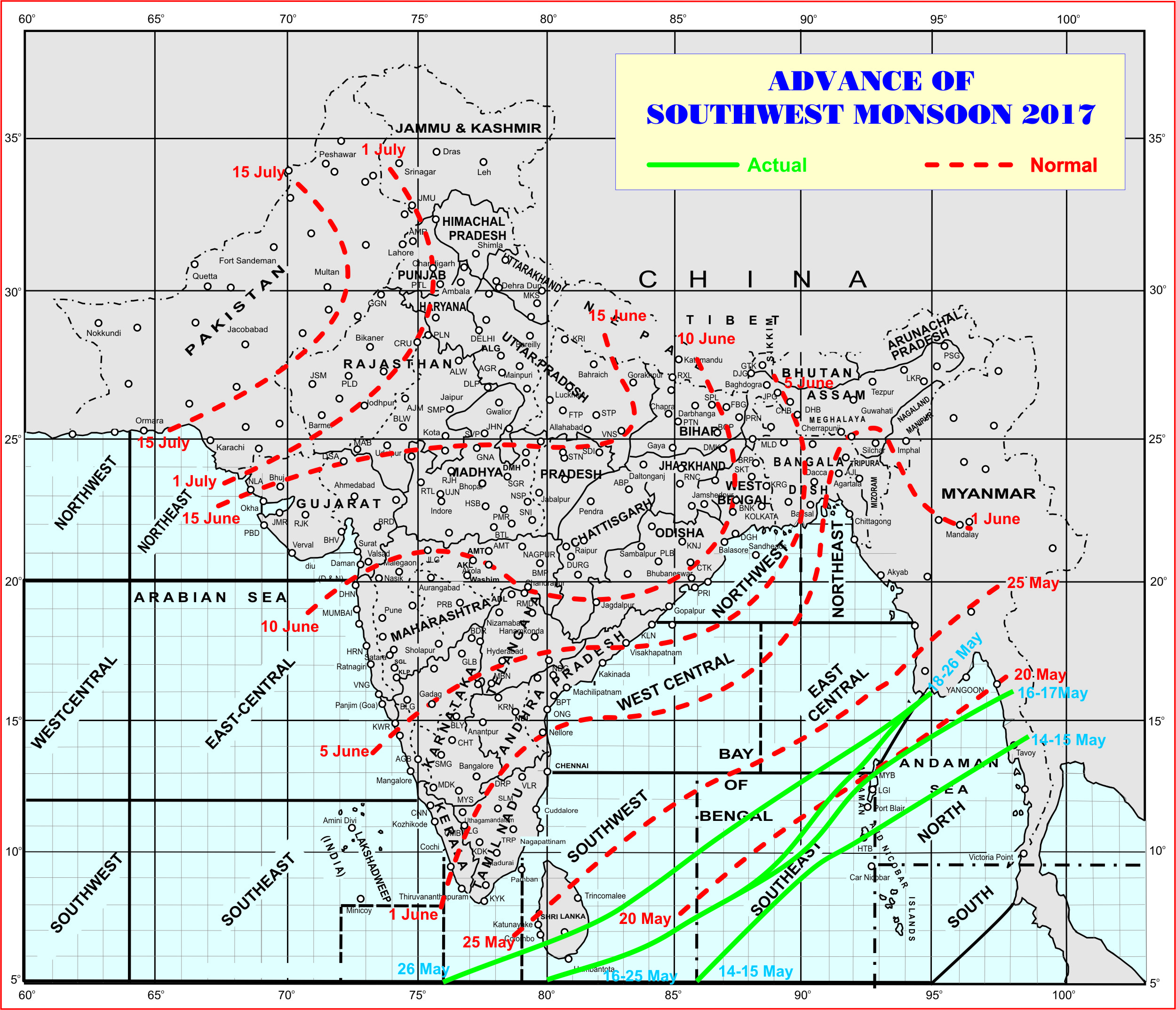
Southwest Monsoon has further advanced into some parts of Comorin area, some more parts of Southwest, Southeast & East Central Bay of Bengal.
The northern limit of monsoon (NLM) passes through 5.0°N/ 76.0° E, 8.0°N/83.0°E, 10.0°N/ 86.0°E, 14.0°N/ 92.0°E and 16.0°N/ 95.0°E.
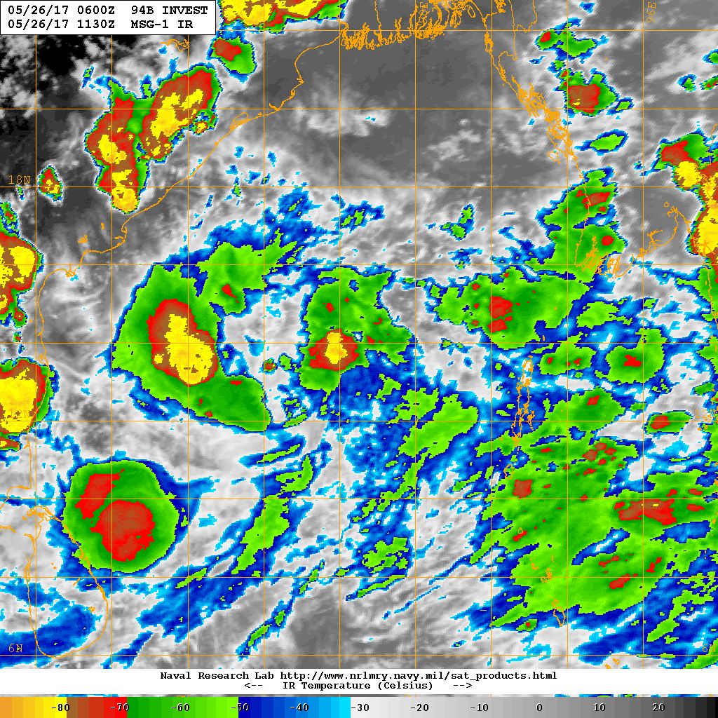
The Low Pressure area over Southeast Bay of Bengal & adjoining Central Bay of Bengal is likely to become Well Marked Low Pressure during next 2-3 days. Under this influence the conditions are becoming favorable for the further advance of Southwest Monsoon in some more parts of Southwest & East Central Bay of Bengal, remaining parts of Southeast Bay of Bengal, some parts of south Arabian sea, entire Maldives-Comorin area and South Kerala & Northeast segment of India by end of the month.
દક્ષિણ પશ્ચિમ ચોમાસુ કોમૉરીન ના અમૂક ભાગો માં તેમજ દક્ષિણ અને મધ્ય પૂર્વ બંગાળ ની ખાડી માં આગળ ચાલ્યું.
દક્ષિણ અને મધ્ય બંગાળ ની ખાડી માં લો પ્રેસર છે જે બેક દિવસ માં મજબૂત થશે. તેની અસર તડે દક્ષિણ પશ્ચિમ ચોમાસુ આગળ ચાલે તેવા સંજોગો રહેશે જેથી 31 મે સુધીમાં ચોમાસુ મધ્ય અને દક્ષિણ બંગાળ ની ખાડી માં, દક્ષિણ આરબ સાગર, સમગ્ર માલદીવ અને કૉમોરિન, દક્ષિણ કેરળ અને ભારત ના પૂર્વોત્તર રાજ્યો માં પ્રસશ કરશે.
Source: IMD
સૌથી ઉપર ની લીલી લીટી ના છેડે જે તારીખ હોઈ તે તારીખે લીટી ની નીચે ના ભાગ માં બધે ચોમાસું પોંચી ગયું છે તેમ સમજવું.
લાલ ત્રુટક લીટી જે તે વિસ્તાર માં નોર્મલ ચોમાસું બેસવાની તારીખ દર્શાવે છે
The date shown at the end of green line shows that the Southwest Monsoon has set in over areas below the green line on that date.
The red dashed line shows the normal date of onset of Southwest Monsoon over various regions.
NRL Satellite IR Image of 94B.INVEST (Low Pressure) on 26th May 2017 @ UTC ( IST)
Top Hot Centers Of India on 26th May 2017


sir.ame unai ma rahiye chiye…varsad ketla divas sudhi avse..janavso plz..laran k amara badha kheduto na ડાંગરના pak khetar ma padela.che
aagahi aapel chhe… vatavaran ashtir chhe…. zaapta hadvo varsad thai shake.
Sir surat ma savar thi zapta ave 6 to have premonsoon activitie keyway k nahi….
Ganaay.
નમસ્તે સર, અરબી સમુદ્રમાં મા કઇ સળવડાટ છે
Tamo kaho chho ke ?
Surat ma savare amuk vistar ma halvo varsad…
Varsad ke chhata ??
rasta bhina kare etla chhata
Sir chomasa ne south West Monsoon kem kehvay?
SOuth India ma temaj Pashchim baju badhe SOuthwest pavano funkaay etle.
sir there is more clouds in BOB but not in Arabian sea so this time also monsoon weak in south west region.
The clouding is due to Depression over BOB. Clouding and winds from Arabian is being pulled to BOB, but it will organise the Southwest winds for Kerala.
Amare varsad eak vars 9jun asapa and eka varas modo thay she to gay sal moto that to aa sal 9 jun asapas varsad that ave lage she DHROL ma
sir bafaro kvo rase avnara divso.ma??
Bafaro vadhshe jem najik chomasu avey tem.
Sir 1 tarik ma Kerala chomasu besi jase
Gujarati ma lakhel chhe te vancho.
sir south kerala moonsoom poche to kerala ma southwest moonsoom besi gyu am samjavu?
Yes
Sir new apde kyare av6e
31 tarikh sudhi nu aapel chhe.
sir mane avu lage chhe k aa season nu second cylone bob ma banse 28,29 tariikh 250hpa chart ma pan anticlockwise pavano fare chhe bangladesh pase…
Te haal Well Marked Low/ Depression ni maatra najik chhe.
Hii sir,
Srilanka ma atiyare vadhu varsad thavanu karan su?
Plz rply sir
Pavano System baju jaay chhe Arabian Sea mathi ane Srilanka ooparthi paas thay chhe.
sir system north to northeast baju gati kari lage chhe…je depresion thase…but sir m.p. east ma pan ek uac jevu lage chhe aagla 2,3 days ma..sachu chhe?
Abhyas chalu rakho… jaanvanu malshe.
Sir Pre monsoon ma varsad ni matra ketali rahache?
Evu kai nakki na hoi.
IMD shear zone banyo se avu kahe se te shear zone atle su ? Monsoon par faydo kare k nukasan
Shear zone etle saam saama pavano.
Tyan varsad maate saru.
Sir, In cyclone low pressure area is formed so atmospheric pressure is low around that area as compared to land area. And wind blows from high pressure to low pressure then why cyclone always attracts land that it always moves towards land or towards high pressure?
Cyclones have low pressure but they are steered by ridges (upper level winds).
sir tame kidhu 7 divas MA pre monsoon Gujarat MA avshe to Aakha Gujarat MA k pachi dakshin Gujarat sudhi j?
to pradesh chhe… baaki nu tamare samajvanu hoi.
nakar taiyar bhajiya !!
keral ma chomasu kyare besase sir
Gujarati ma lakhel chhe… vancho.
Sir, for knowledge only. Any monsoon or pre monsoon activity or any system like UAC, Law pressure etc. which are helping Saurastra and Gujarat region’s monsoon more. Are they started their activity after SW monsoon reach at Maharashtra region only? I Mean Activities over Arabian sea has any direct connection to BOB or they has separate fundament of working.
Initially they are independent.
The Arabian side gets organised due to Monsoon trough ( which becomes Axis of Monsoon ) over Northwest India and stretching towards Bay of Bengal.
Yes once Monsoon reaches Mumbai we see changes in atmosphere.
If any System from BOB come till M.P. the moisture from Arabian Sea gets pulled over across Gujarat towards M.P. and in this way there is a connection.
Date 3 thi 5 june ma ARB ma keral/Goa pase Lp thay tevi shakyata chhe.but,it will go off in Northwest direction towards oman???
Abhyas chalu rakho.
Sir.ta.2.3 ma arbi ma hil chal thay tevu lage 6. Sachu ne sir. Pls ans.
Abhyas chalu rakho… forecast model ma fer far thaya rakhe chhe.
Sir aaje pavan ni gati ma khub vadharo jova mali rahyo 6..
Sir aa varas off shore tough nu mathlu saurstra par bandhse jema bhare varsad ave chhe apne
Saurashtra ne Off-shore trough laabh ochho hoi chhe.
Dakshin Gujarat sudhi te laabh hoi chhe.
Sir; pre monsoon saurastra par kyare active thase?
5 thi 7 divas ma.
Sir null school ma je vadhare ghato lilo rang batave te pavan ni vadhare speed che k?
Tyan click karo etle ek box ma badhi mahiti aavashe… jem ke pavan ni speed ane location.
Good news sir
Sir vavajodu kyare avse bob valu
BOB ma haal koi vavazodu nathi, Well Marked Low Pressure chhe.
Hi Ashok Bhai,
1k question thay che k India ma sari garmi kahevay evo aank kyo? 40deg., 42deg., 45deg.?
Because tapman to vasti ne karane ane vahano ma thi nikadta karbon dioxide ne karane vadhare vadhyu che.
Baki originally to 35deg. upar no koi bhi aank garmi j kahevay ne?
Thank you.
Tamari moti samaj fer chhe. Tamaro vaank nathi pan mahiti khoti pirsaay chhe. CO2 havaman ma khas kai fer kari shake nahi. Vadadaa, water vapor temaj Dariya nu paribad vadhare mahatva nu chhe.
Chhella 100 varsh ma Taapmaan ni sharerash 1 C thi ocho vadharo thayel chhe.
Teni saame dar roj savar ane bapor na taapmaan ma 15 thi 18 C vadhghat thati hoi chhe.
Rajkot ma 47.9 C Taapmaan 13 May,1977 ma thayel tyare CO2 ochhu hatu.
CO2 te Vanaspati, kheti paako, tree, vigere no khorak chhe. tenathi vanraay vadhe chhe ane chhella 50 varsh ma vadhi chhe.
Thank you Ashok Bhai,
You cleared my myth 🙂 Mane to am hatu k salu aagad na varso mate bahu kapru che varsad nu vadhu pdvu but have haas thai 🙂 haha
Maja pdi aa vastu jani ne 🙂
Thank you again 🙂
Good news
Sir email address khotu 6 maru
Tamo kaho chho ke puchho chho ?
Amook comment prasiddh na thaya hoi…. vaat ma kai dam na hoi toe.
Sir Aa vakhate arabi samudra ma Low pressure Taine 5 ke 6 tharike gujrat ma premonsson varsad entry karse?
Hu laamba gaada ni aagahi karto nathi
Good news sir
sir system bangaldesh baju track batave che t southwest moonsoom par effect thai sake Bcs South india avva badle North east baju jay che atle?
Te System thi pavano Southwest na gothavaay chhe.
Sir.Visavdar ti dahri vistar ma aaje lu sav ochi hati pavan zatka no hato
Null School ma jota pavan ARB mathi southwest baju j funkay rahya chhe.
That’s good……
Barobar chhe pan Kerala maate 600 hPA ma pan pavan speed ane disha barobar hovi jiye.
Aa badhu IMD kahe tem ganay. Ee declare kare etle chale.
Subh samachar…thanks for good news sir….
Sir ji.. Low pressure cyclone ma parivartit thay to monsoon ni aagal vadhvani speed ma vadharo thay ke ghatado???
System kai baju jaati hoi tena oopar pavano ni disha nakki thay.
Pavan Arabian mathi Southwest mathi funkaay toe faaydo thaay.
Good news