Current Weather Conditions on 14th September 2012 @ 7.00 am. IST
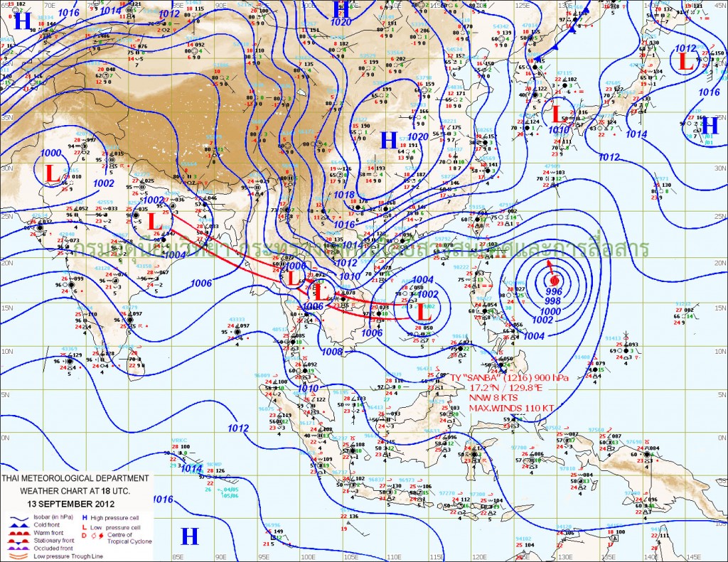
The Upper Air Cyclonic Circulation over Kutch and nearby area has now weakened. The Axis of Monsoon trough at mean sea level runs close to foothills of Himalayas and then passes through Bahraich, Gorakhpur, Patna, Asansol, Diamond Harbour and thence Southeastwards to Eastcentral Bay of Bengal. Yesterday’s Cyclonic Circulation over Jharkhand and vicinity is now over West Bengal and vicinity. The Off-shore trough runs from Gujarat Coast to Kerala Coast.
TMD Weather Map dated 13th September 11.30 pm. IST
Due to the effects of Upper Air Cyclonic Circulation that persisted over the general areas of Gujarat, Saurashtra, Kutch, Sindh and nearby Northeast Arbian Sea during the last more than seven days and from cumulative effects of the two Systems that came in proximity of Gujarat during this period, very good round of rainfall has occurred over the whole of Gujarat including Saurashtra & Kutch.
Kutch had received 13% of Average Yearly Rainfall till 3-09-12 and has now achieved 57% Average Yearly Rainfall on 13-09-12
North Gujarat had received 47% of Average Yearly Rainfall till 3-09-12 and has now achieved 78% Average Yearly Rainfall on 13-09-12
East-Central Gujarat had received 54% of Average Yearly Rainfall till 3-09-12 and has now achieved 79% Average Yearly Rainfall on 13-09-12
South Gujarat had received 47% of Average Yearly Rainfall till 3-09-12 and has now achieved 66% Average Yearly Rainfall on 13-09-12
Saurashtra had received 28% of Average Yearly Rainfall till 3-09-12 and has now achieved 53% Average Yearly Rainfall on 13-09-12
Whole of Gujarat had received 43% of Average Yearly Rainfall till 3-09-12 and has now achieved 68% Average Yearly Rainfall on 13-09-12
This means Gujarat State received overall 25% of Average Yearly Rainfall was received just in 10 days from morning of 3rd September to morning of 13th September 2012.
Forecast: 14th to 19th September 2012
No System is expected to affect Saurashtra, Gujarat & Kutch during this period.
Rainfall activity will be minimal over Saurashtra & Kutch with scattered showers during the forecast period.
Light to Medium Rainfall forecast for parts of Central and South Gujarat on 14th/15th and then only scattered showers for the remaining forecast period.
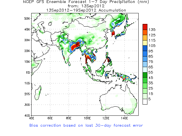
The Monsoon will be active towards the Himalayas, North, Eastern and Northeast India as can be seen from this NCEP/GFS Ensemble Forecasts Map
As per IMD guideline on withdrawal of Southwest Monsoon, Cessation of rainfall activity over the area for continuous 5 days, Establishment of anticyclone in the lower troposphere (850 hPa and below) & Considerable reduction in moisture content as inferred from satellite water vapor images. Hence, we can conclude that Monsoon has not yet withdrawn from northwest India and is not expected to do so in the next five days.


Khudosssssssss!!!!!!!!!!!!
U r genious, your predictions are so well written. I mean i am follwoing you from last 2 years, and not a single prediction was wrong.
Even today you are so right…………………..
Thanks & Regards,
Nirali