2023-24 El Nino ONI Below 2°C End Of February 2024 – El Nino Expected To Continue Weakening Further Next Couple Of Months
Enso Status on 5th March 2024
Ashok Patel’s Analysis & Commentary :
The classification of El Niño events, including the strength labels, is somewhat subjective and can vary among meteorological and climate agencies. There isn’t a strict rule defining the specific number of consecutive Oceanic Niño Index (ONI) values that must be 2.0°C or above to categorize an El Niño event as “Super Strong.”
In general, a strong El Niño event is often characterized by ONI values reaching or exceeding +2.0°C. A Super Strong El Niño would typically involve sustained ONI value of +2.0°C or more. Hence for ease of understanding and comparing the strength of various Strong El Nino events, I propose to define an El Nino as a Super Strong event if three consecutive ONI index is +2.0°C or more.
ONI Data has been obtained from CPC – NWS – NOAA available here
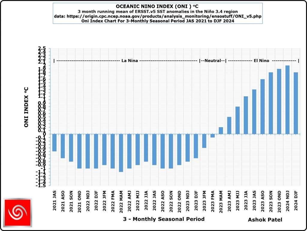
The current forecast and analysis clearly indicates that the 2023-24 El Nino will not become a Super Strong El Nino, since the ONI has already dropped below +2.0°C to latest value of +1.8°C for DJF2024. ONI is expected to decrease henceforth.
How ONI is determined:
The ONI is based on SST departures from average in the Niño 3.4 region, and is a principal measure for monitoring, assessing, and predicting ENSO. Defined as the three-month running-mean SST departures in the Niño 3.4 region. Departures are based on a set of further improved homogeneous historical SST analyses (Extended Reconstructed SST – ERSST.v5).
NOAA Operational Definitions for El Niño and La Niña, El Niño: characterized by a positive ONI greater than or equal to +0.5ºC. La Niña: characterized by a negative ONI less than or equal to -0.5ºC. By historical standards, to be classified as a full-fledged El Niño or La Niña episode, these thresholds must be exceeded for a period of at least 5 consecutive overlapping 3-month seasons.
CPC considers El Niño or La Niña conditions to occur when the monthly Niño3.4 OISST departures meet or exceed +/- 0.5ºC along with consistent atmospheric features. These anomalies must also be forecast to persist for 3 consecutive months.
The Climate Prediction Center (CPC) is a United States Federal Agency that is one of the NECP, which are a part of the NOAA
Latest Oceanic Nino Index Graph Shows Strong
El Nino Conditions Are Prevailing At The End Of February 2024
The Table below shows the monthly SST of Nino3.4 Region and the Climate adjusted normal SST and SST anomaly from July 2021. Climate Base 1991-2020. ERSST.v5
Period    Nino3.4 ClimAdjust
YR   MON  Temp.ºC Temp.ºC ANOM ºC


2021   7   26.90   27.29   -0.39
2021   8   26.32   26.86   -0.53
2021   9   26.16   26.72   -0.55
2021  10   25.78   26.72   -0.94
2021  11   25.76   26.70   -0.94
2021  12   25.54   26.60   -1.06
2022   1   25.61   26.55   -0.95
2022   2   25.88   26.76   -0.89
2022   3   26.33   27.29   -0.97
2022   4   26.72   27.83   -1.11
2022   5   26.83   27.94   -1.11
2022   6   26.98   27.73   -0.75
2022   7   26.60   27.29   -0.70
2022   8   25.88   26.86   -0.97
2022   9   25.65   26.72   -1.07
2022  10   25.73   26.72   -0.99
2022  11   25.80   26.70   -0.90
2022  12   25.75   26.60   -0.86
2023   1   25.84   26.55   -0.71
2023   2   26.30   26.76   -0.46
2023   3   27.19   27.29   -0.11
2023   4   27.96   27.83    0.14
2023   5   28.40   27.94    0.46
2023   6   28.57   27.73    0.84
2023   7   28.31   27.29    1.02
2023   8   28.21   26.86    1.35
2023   9   28.32   26.72    1.60
2023  10   28.44   26.72    1.72
2023  11   28.72   26.70    2.02
2023  12   28.63   26.60    2.02
2024   1   28.37   26.55    1.82
2024   2   28.33   26.76    1.56
Indications and analysis of various International Weather/Climate agencies monitoring ENSO conditions is depicted hereunder:
Summary by: Climate Prediction Center / NCEP Dated 8th February 2024
ENSO Alert System Status: El Niño Advisory / La Niña Watch
El Niño conditions are observed.*
Equatorial sea surface temperatures (SSTs) are above average across the central and eastern Pacific Ocean.
The tropical Pacific atmospheric anomalies are consistent with El Niño.
A transition from El Niño to ENSO-neutral is likely by April-June 2024 (79% chance), with increasing odds of La Niña developing in June-August 2024 (55% chance).*
Note: Statements are updated once a month (2nd Thursday of each month) in association with the ENSO Diagnostics Discussion, which can be found by clicking here.
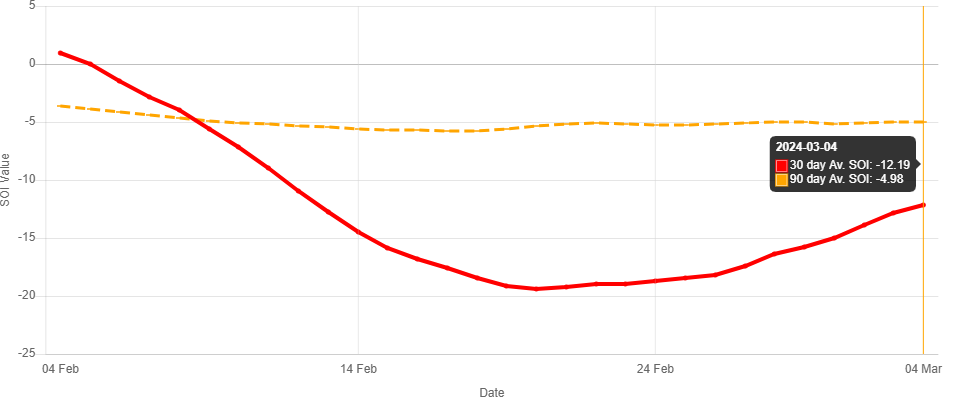
Recent (preliminary) Southern Oscillation Index values as per The Long Paddock – Queensland Government.
30 Days average SOI was -15.55 at the end of February 2024 and was -12.19 on 4th March 2024 as per The Long Paddock – Queensland Government and 90 Days average SOI was -4.98 on 4th March 2024. During February 2024 the SOI had been negative and continues to be so on 4th March 2024.
Southern Oscillation Index
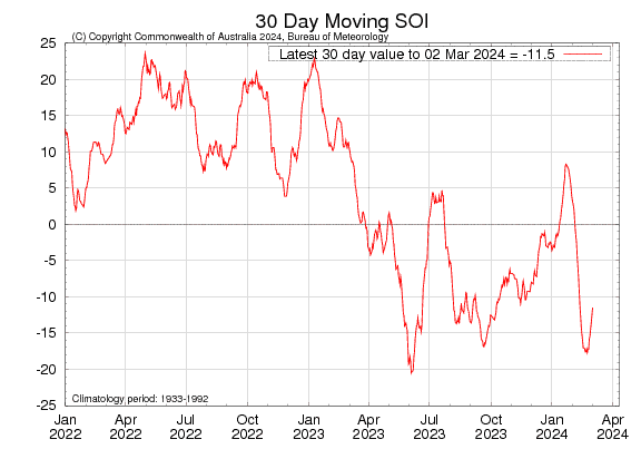
As per BOM, Australia
The 30-day Southern Oscillation Index (SOI) for the period ending 29th February 2024 was -13.5 and was -11.5 on 2nd March 2024 and is moving towards negative direction once again..
Sustained negative values of the SOI below −7 typically indicate El Niño while sustained positive values above +7 typically indicate La Niña. Values between +7 and −7 generally indicate neutral conditions.
As per BOM – Australia 5th March 2024
Neutral ENSO likely during Autumn
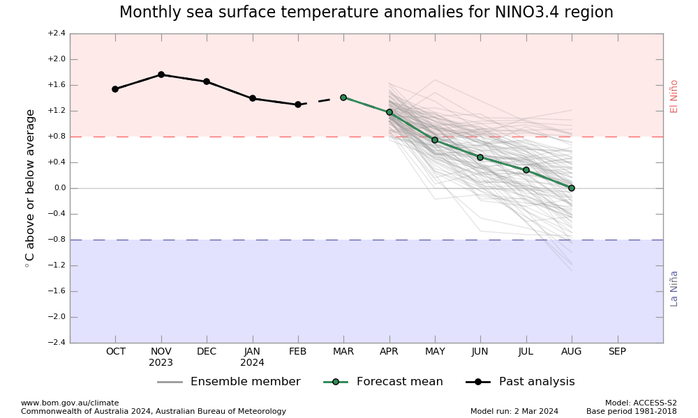
El Niño persists, although a steady weakening trend is evident in its oceanic indicators. Climate models indicate sea surface temperatures in the central tropical Pacific are expected to continue declining and are forecast to return to ENSO-neutral in the southern hemisphere autumn 2024.
Atmospheric indicators are mixed but are consistent with a steadily weakening El Niño. Cloudiness near the equatorial Date Line has decreased over the last fortnight, returning to the climatological average. The 30-day Southern Oscillation Index (SOI) is currently less than -7.0, characteristic of an El Niño state, but indicative of ENSO-neutral conditions over the 60- and 90-day periods. Temporary fluctuations of ENSO atmospheric indicators are common during summer and are not an indication of El Niño strength.
International climate models suggest the central tropical Pacific Ocean will continue to cool in the coming months, with four out of seven climate models indicating the central Pacific is likely to return to neutral El Niño–Southern Oscillation (ENSO) levels by the end of April (i.e., neither El Niño nor La Niña), and all models indicating neutral in May. ENSO predictions made in autumn tend to have lower accuracy than predictions made at other times of the year. This means that current forecasts of the ENSO state beyond May should be used with caution.
Note: All Seasons mentioned by BOM are with respect to Southern Hemisphere.


તારીખ 7 માર્ચ 2024 આજની પરિસ્થિતિ ભારતીય હવામાન વિભાગ અનુસાર મીડ ડે બુલેટિન ❖ એક વેસ્ટર્ન ડિસ્ટર્બન્સ હવે ઉત્તર પાકિસ્તાન પર UAC તરીકે છે અને તે સરેરાશ સમુદ્ર સપાટીથી 3.1 કિમી પર છે અને તેની સાથે મીડ લેવલ ના પશ્ચિમી પ્રવાહો માં ટ્રફ તેની ધરી સાથે સરેરાશ સમુદ્ર સપાટીથી 5.8 કિમી ની ઊંચાઈ એ આશરે 67°E અને 30°N થી ઉત્તર તરફ છે. ❖ એક ઈન્ડ્યુઝ સાયક્લોનિક સરક્યુલેશન દક્ષિણપશ્ચિમ રાજસ્થાન અને લાગુ પાકિસ્તાન પર છે અને તે સરેરાશ સમુદ્ર સપાટીથી 0.9 કિમી પર છે. ❖ એક ટ્રફ હવે પશ્ચિમ વિદર્ભથી ઉત્તર તમિલનાડુ સુધી લંબાય છે અને તે સરેરાશ સમુદ્ર સપાટીથી 1.5… Read more »
Sir avu lage chhe…5 divas ma tapman 5 degree jetlu vadhi jase…barabar chhe sir…?
7 tarikh sudhi taapman normal baju jashe
સર જય શ્રીકૃષ્ણ સરસ મજાનું અપડેટ બદલ ખુબ ખુબઅભિનંદન ….
તારીખ 6 માર્ચ 2024 આજની પરિસ્થિતિ ભારતીય હવામાન વિભાગ અનુસાર મીડ ડે બુલેટિન ❖ વેસ્ટર્ન ડિસ્ટર્બન્સ મીડ લેવલ ના પશ્ચિમી પ્રવાહો માં ટ્રફ તરીકે તેની ધરી સાથે સરેરાશ સમુદ્ર સપાટીથી 5.8 કિમી ની ઊંચાઈ એ આશરે 62°E અને 32°N થી ઉત્તર તરફ છે. ❖ પંજાબ અને તેના આસપાસના વિસ્તાર પરનું UAC હવે ઉત્તર-પશ્ચિમ ઉત્તર પ્રદેશ અને લાગુ હરિયાણા પર છે અને તે સરેરાશ સમુદ્ર સપાટીથી 3.1 કિમી પર છે. ❖ દક્ષિણ તમિલનાડુથી ઉત્તર આંતરિક કર્ણાટક સુધીનો ટ્રફ હવે દક્ષિણ તમિલનાડુથી આંતરીક કર્ણાટકમાં થય ને પૂર્વ વિદર્ભ સુધી લંબાય છે અને તે સરેરાશ સમુદ્ર સપાટીથી 0.9 કિમી પર છે. ❖ એક… Read more »
Sar 10thi14 kye che gam માવઠું સાચું છે
te Gaam ne khabar !
એનો જવાબ ગામ ના ચોરે તમને મળશે!!!
Thanks sir
જય માતાજી
સારા સમાચાર
Jay mataji sir…thanks for new information…
Good News….
અપડેટ આપવા બદલ આભાર સાહેબ.મતલબ કે અલનીનો નબળો પડશે, અને આવનાર ચોમાસા માટે સારા સમાચાર કહેવાય ને ?
Thanks for good news sir
Waah!! Thanks for the information sir.
Thanks, sir
Good news. Means El nino will not impact this monsoon. It will totally weaken till June.
Thank you sir