Current Weather Conditions On 14th June 2013 @ 1.00 pm.
The Well Marked Low Pressure area over south coastal Odisha and neighborhood now lies as a low pressure area over Chhattisgarh and neighborhood. Associated cyclonic circulation now extends up to 7.6 kms a.s.l., tilting southwestwards with height.
The trough at mean sea level now runs from West Rajasthan to East Central Bay of Bengal across East Rajasthan, Madhya Pradesh, the Center of the Low Pressure area and South Odisha.
The off-shore trough at mean sea level extends from South Gujarat coast to Kerala coast.
The Cyclonic Circulation lies over Northeast Arabian Sea and parts of Saurashtra & Kutch.
NCEP/GFS Bias-Corrected Precipitation Forecasts
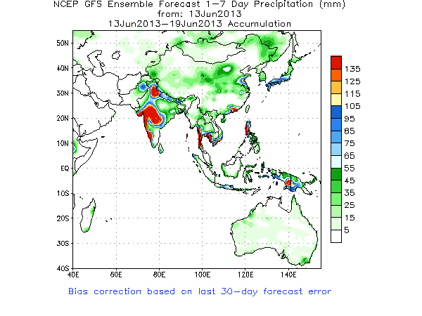
The Monsoon is expected to be vigorous for the next two weeks as can be seen from the Indian Monsoon Index.
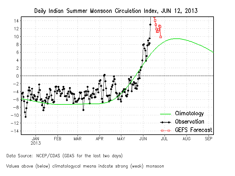
Forecast: 14th June to 20h June
The Low Pressure is expected to track mainly West Northwestwards over Chhatishgarh, Vidarbh and then M.P. and then Northeast Rajasthan North Gujarat border area.
From 14th to 16th June there will be scattered rain over Saurashtra & Gujarat due to combined effects of the UAC in Northeast Arabian Sea and vicinity & the Monsoon trough along the South Gujarat Coast.
16th to 20 June:
Due to the effects of the Low Pressure and associated UAC that will reach the vicinity of Gujarat, conditions will be very good for heavy to very heavy rainfall over Gujarat. Some parts of Gujarat are expected to receive extreme heavy rainfall during the forecast period of 16th to 20 June. Some parts of Saurashtra will receive heavy rainfall while other parts along with Kutch will receive moderate rainfall.
Quantum of rainfall forecast:
South Gujarat, Central Gujarat & Northeast Gujarat expected to receive 10 Cms. to 15 Cms. with isolated places getting 20 Cms. of rainfall during the forecast period.
50 % of Saurashtra and rest of Gujarat expected to receive 6 Cms. to 10 Cms. during the forecast period.
Balance 50 % of Saurashtra & Kutch expected to receive 4 Cms. to 6 Cms. during the forecast period.
Note: Further update will be given as and when warranted. This forecast does not imply that all the regions will receive rain on all the days of the forecast period. This forecast is given up to 20th June and does not imply anything about what will happen from 21th June onwards.
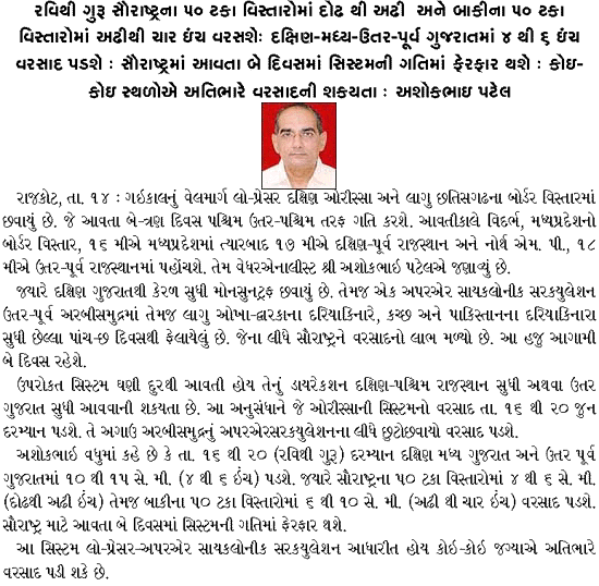
Weather Forecast In Akila Daily dated 14th June 2013 @ 9.30 am.


Dear Sir your efforts in weather analysis are really helpful thanks for all your activities, sir can u please help us how to read graphs (in one graph air movement is shown in red & green dash lines with directions & date how to analyze it )
we will be thankful if you can share some knowledge on it.
Ane haji pan vavni layak
Varshad nathi tahyo
Sir…
૧૬થિ ૧૮ માં થશે
Dear.: Sir.
Gadhada ( swaminarayun)
Dist.bhvnagar.
Swaminarayun bhagvan ni
Karrm.bhumi.che.sir..
sir odisa na low pressure thi rajkot ane amareli district ma kevo varsad padche?
આગાહી માં આપેલ છે તેના થી હાલ વિશેષ કઈ નથી.
Thnk u sir:-)
Sir, i mean ke porbandar ma kevo varsad che te pramane vavetar kariye,sir vadhu varsad aave to magfali na uge sir.
એક એક ગામ માં કેમ રહેશે તે કહેવું શક્ય નથી.
Thank you sir, kale vavetar thay tem che.
Pela na round ma amara gaam gadhada ma varshad nathi pado to aa nava raund ma aavshe khra sir..??????
ગઢડા ક્યાં આવ્યું… જીલ્લો અને નજીક માં બીજું ગામ કયું. વાવણી નથી થઇ ?
Hello sir, tame j kahyu hatu te pramane 10 inch varsad paido! Pan have sir kale magfali nu vavetar karvu joiye k nay te janvso plzzz its argnt. From porbandar.
મગફળી નું વાવેતર કરવા માટે તમારે નક્કી કરવાનું હોઈ. મોકો મળે વાવી દેવું.
Just now rain comes in Jamnagar.
good start and well flow
Please inform amount of rain when it stops.