Current Weather Conditions on 19th July 2013 @ 2.00 pm.
A fresh Low Pressure area has formed over Northwest Bay of Bengal and neighboring West Bengal & Odisha Coast. Associated Cyclonic Circulation extends upto 7.6 kms above Sea Level, tilting Southwestwards with height.
The axis of monsoon trough at mean sea level passes through Ferozepur,
Muzaffarnagar, Kanpur, Ambikapur, Paradip, Center of Low Pressure area and
thence Southeastwards to East Central Bay of Bengal.
There is a weak off shore trough at mean sea level along South Gujarat coast to Kerala coast.
The UAC from the earlier Low Pressure is over Northeast Madhya Pradesh and adjoining South Uttar Pradesh.
The Bay of Bengal Low Pressure would remain over Northwest Bay of Bengal and vicinity for the next three days.
Monsoon winds have picked up speed over Arabian Sea and hence there is good moisture incursion over Saurashtra & Gujarat. Overall weather is gradually improving for Saurashtra & Gujarat.
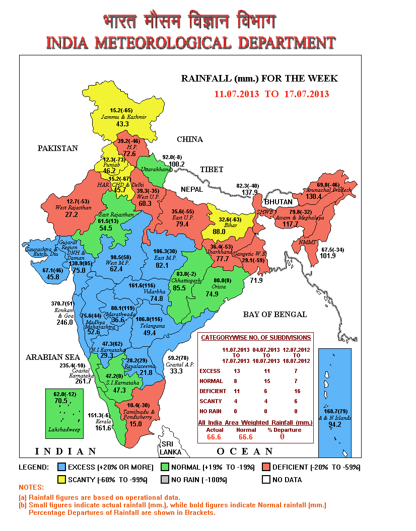
IMD Map showing Rainfall over India for the Week ending 17th July 2013
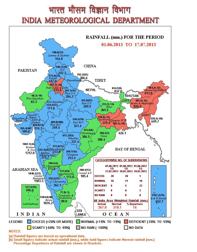
IMD Map showing Yearly Rainfall over India from 1st June to 17th July 2013
The above two maps show that Saurashtra, Kutch & Gujarat have received above normal rainfall both on yearly basis as well as for last week.
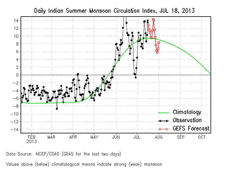
Indian Monsoon Circulation Index shows that the Monsoon will be active for next 10 days over India since the Index is above 10 for the next 10 days.
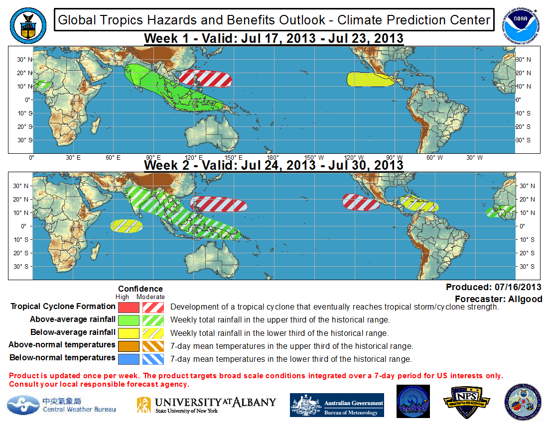
Global Tropical Hazards & Benefits Outlook from CPC for week 1 valid 17th July to 23rd july shows above normal rainfall for Southern Peninsula, Gujarat, Maharashtra, M.P., Chhatishgarh, Odisha, W.B.
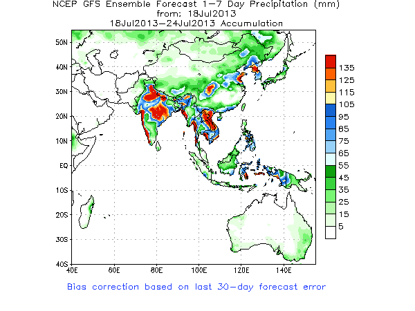
NCEP/GFS Bias-Corrected Precipitation Forecasts
The above map shows that Saurashtra will receive 35 to 75 mm. of rainfall during the forecast period, while South Gujarat could receive 100 to 135 mm. and North Gujarat and Central Gujarat could get 50 to 100 mm. during the forecast period. Kutch could get 25 to 50 mm.
Forecast: 19th to 24th July 2013
There will be scattered rain on most days of the forecast period though over different areas of the regions on different days with more quantum on 21st to 23rd July.
60% of Saurashtra will receive light to medium rainfall on various days totaling up to 35 mm. to 50 mm. while rest Saurashtra expected to get rain showers and light rain on multiple days with more quantum on 21st to 23rd July total up to 25 mm. to 35 mm. Some isolated places could receive cumulative above 100 mm. of rainfall.
North Gujarat & Central Gujarat is expected to receive light to medium rainfall on various days with more quantum on 21st to 23rd July cumulative total rainfall 50 mm. to 100 mm. during the forecast period with isolated places getting above 100 mm.
South Gujarat is expected to receive 100 mm. to 135 mm. rainfall during the forecast period.
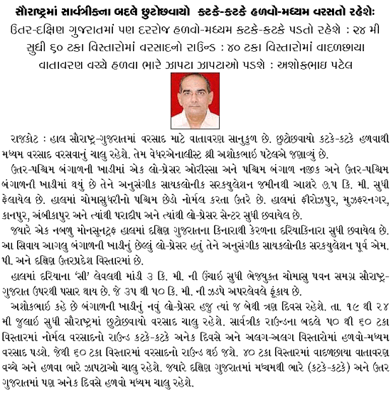
Sir
રાજકોટ થી અહેમદાબાદ સુધી. તારીખ ૨૮/૦૭/૨૦૧૩ ના રોજ વરસાદ ની શક્યતા છે
sir well mark low in nw bob what is the direction of this system according to your forcast model
As per NCEP/GFS Bias-Corrected Forecasts(21 July to 27 July), Condition is very Good for South Gujarat Saurashtra and North Gujarat and can get 80mm to 135 mm and Kutch can get 45 mm to 75 mm.
sir BOB. na low prresur thi saurashtra ne faydo thashe?
sir 24th 25th saurashtra ma sara varsad ni shkyata chhe?
Sir tmd wether chart ma pakistan upar je low pressure chhe tenathi kay fayado ke nahi?
પાકિસ્તાન બાજુ જે લો પ્રેસર છે તે ચોમાસું ધરી નો પશ્ચિમ છેડો છે. ચોમાસું ધરી ત્યાંથી બંગાળની ખાડી ના લો સુધી લંબાય છે. ચોમાસું ધરી સીસ્ટમ ને ચાલવા માટે નો હાઇવે છે. સામાન્ય રીતે કોઈ પણ સીસ્ટમ આ ચોમાસું ધરી ઉપર આગળ ચાલતી હોઈ છે. આ ધરી નો પશ્ચિમ છેડો ક્યારેક ગુજરાત તરફ સરકે ત્યારે સૌરાષ્ટ્ર કચ્છ ને ગુજરાત ને વધુ ફાયદા કારક રહે.
Sir ncep/gfs ma 22 thi 28 julai sudhima 135 mm varsad ni sakyta batave chhe to bob saurashtra ne asar karase aem manavu ke?
Sir, I asked same question which asked by someone ..in compare to other saurashtra region’s rain this year rajkot is getting less rain. Is there any specific reason for that ?
સરકારી આકડા મૂજબ ૩૬૮ મીમી વરસાદ રાજકોટ માં પડ્યો છે જે સીઝન નો ૬૪૨ મીમી સામે ૫૭ % થયો છે જે નોર્મલ થી વધુ ગણાય.
Rajkot has received 57.33% of seasonal average rain which is near normal compared to rest of Rajkot District with 60 % rain.
Dear Ashokbhai,
Today’s NCEP GFS Ensemble Forecast map for 20-26 July is showing upto 135 mm rain for most of saurashtra region. Is this forecast with consideration of the track of the recently formed LPA over BoB? If this is so, then it will definitely benefit the region.
Yes 60 % of Saurashtra is forecast to get in NCEP GFS map about 135 mm. and rest of the area about 75 to 90 mm. However, this could change in a day or two. The BOB low is expected to remain on east side till next few days and could track Westwards from 24th/25th so on 26th could affect Saurashtra. The scenario needs to be watched.
Your observation is correct and I am glad you are keenly interested in Weather Forecasts.
સર રાજકોટ માં વરસાદ કેમ બહુ ઓછો વરસાદ તેમનું કારણ શું હોઈ શકે?
સરકારી આકડા મૂજબ ૩૬૮ મીમી વરસાદ રાજકોટ માં પડ્યો છે જે સીઝન નો ૬૪૨ મીમી સામે ૫૭ % થયો છે જે નોર્મલ થી વધુ ગણાય.
In current forecast You did not mentioned anything about Kutch. So will Kutch receive rain during this forecast period? Also we can feel that some moisture leve is increased in kutch also.
Above the forecast there is a map showing precipitation. Below that map is written “Kutch could get 25 to 50 mm.”
bhanvad vistarma asar kevi raheshe sir!
sir odis bangal low pressure guj ma heavy rain lavi sake?
હાલ માં લો તે વિસ્તાર માં રહેશે પછી શું થાય તે અભ્યાસ ચાલુ છે.