Current Weather Conditions on 9th October 2013 @ 10.30 am.
90W.INVEST tracked over the Gulf Of Thailand over to the North Andaman Sea and on 7th October developed into a A Low Pressure area and further intensified to a Depression on 8th October.
As per IMD Bulletin No. BOB 04/2013/05 Time of issue 0900 hours IST Dated 09-10-2013:
The depression over North Andaman Sea moved northwestward with a speed of 13 kmph during past 6 hours, intensified into a deep depression and lay centred at 0530 hrs IST of today, the 09th October 2013 over north Andaman Sea near latitude 13.00N and longitude 93.50E, about 170 km north-northeast of Port Blair, 1100 km east-southeast of Paradip, 1200 km east-southeast of Visakhapatnam. The system would intensify into a cyclonic storm during next 12 hours. It would move west-northwestwards and cross Andaman islands near Mayabandar by noon of today, the 9th October 2013 as a cyclonic storm. It would then continue to move west-northwestwards for some time and then northwestwards and cross north Andhra Pradesh and Odisha coast between Kalingapatnam and Paradip by night of 12th October, 2013 as a very severe cyclonic storm with a maximum sustained wind speed of 175-185 kmph.
As Per JTWC the System is monitored as Tropical Cyclone 02B(TWO)
Tropical Cyclone 02B (Two) Warning #01 Issued at 09/0300Z

NRL Meteo 7 IR Satellite Image of 02B TWO on 9th October 2013 @ 0400 UTC (9.30 am. IST)

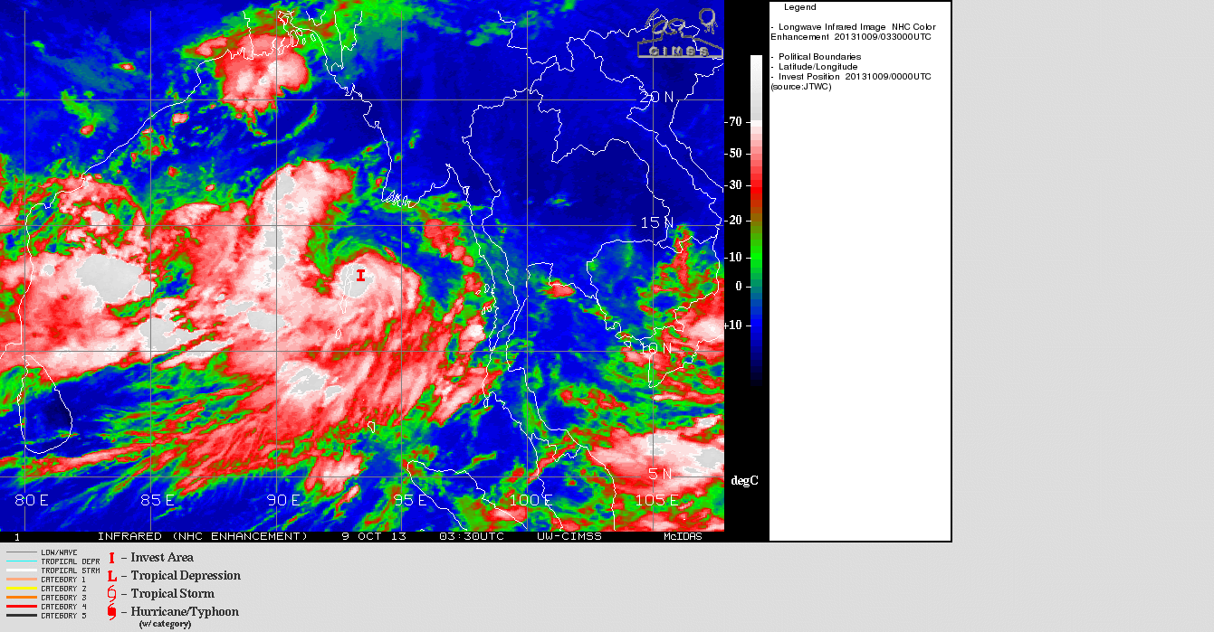
UW-CIMSS Satellite Image of 02B.TWO on 09102013 @ 0330z
sahebji
nava low pressure ni asar thi gujarat( sabatkantha) ma varsad ni sakyata janay 6?
ના તે સીસ્ટમ ઓડીશા બાજુ હાલ જાય છે માટે ગુજરાત ને અસર થાય તેમ નથી લાગતું પરંતુ હાલ ગુજરાત ma વરસાદ ની શક્યતા છે.
હવામાન ખાતા ની સૂચના ને અનૂસરવું.
sir
bhayavadar ma kal 75-100mm
varsad che
avta divaso nu vatavaran kevu hase?
આગાહી માં આપેલ છે તેમ ગણો
sir
bhayavadar ma kal 75-100mm
varsad che
avta divaso nu vatavar kevu hase?
SIR,
A M CHANDRA IN UR WEBSITE WHO HAS GIVEN PREDICTION FOR THIS YEAR IS BULLS EYE.. QUESTION IS WILL IT EFFECT GUJARAT ? ACCORDING TO GRAPH U GIVEN ITS NOT EFFECTING GUJARAT… IS IT?
The Deep Depression is heading towards Odisha and will not affect Gujarat. However, Saurashtra & Gujarat will receive rain as per forecast given earlier.
Refer/Rely upon IMD/RSMC Bulletins/Advisories.
સર અત્યારે તો કંઇ કહી ના શકાય ને કે આ વાવાઝોડુ ગુજરાત બાજુ આવશે કે નય?આપનુ શું કહેવુ છે.અને પાકિ ખબર કંઇ તારિખે પડશે?કે ગુજરાત બાજુ આવે એમ છે કે નય?
હાલ ના અનુમાન મૂજબ આન્ધ્ર ઓડીશા બોર્ડર વિસ્તાર માં ૧૨ તારીખ આસપાસ પોંચશે.
હવામાન ખાતા ની સૂચના ને અનૂસરવું