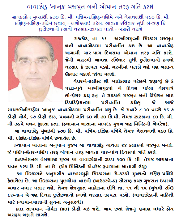
Current Weather Conditions on 12th June 2014 @ 10.00 am.
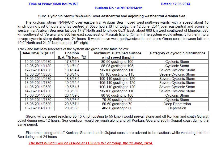
IMD Bulletin ARB01/2014/12 Dated 12th June 2014 issued at 0830 am.
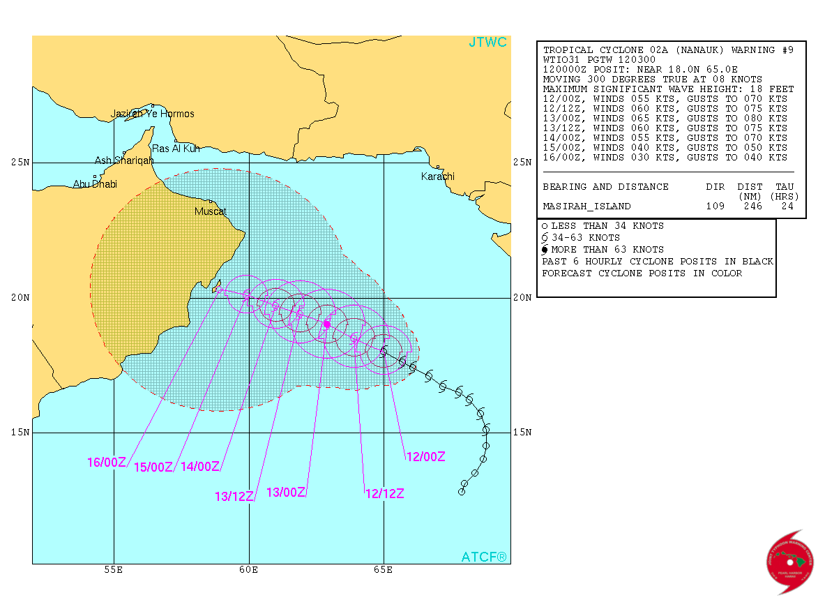
JTWC Tropical Cyclone 02A (Nanauk) Warning #09
Issued on 12th June 2014 @ 0300Z
Tropical Cyclone 02A (Nanauk) Warning #09 Map
JTWC Location & Strength on 12th June 2014 @ 0300Z:
WTIO31 PGTW 120300
MSGID/GENADMIN/JOINT TYPHOON WRNCEN PEARL HARBOR HI//
SUBJ/TROPICAL CYCLONE 02A (NANAUK) WARNING NR 009//
RMKS/
1. TROPICAL CYCLONE 02A (NANAUK) WARNING NR 009
   01 ACTIVE TROPICAL CYCLONE IN NORTHIO
   MAX SUSTAINED WINDS BASED ON ONE-MINUTE AVERAGE
   WIND RADII VALID OVER OPEN WATER ONLY
    ---
   WARNING POSITION:
   120000Z --- NEAR 18.0N 65.0E
     MOVEMENT PAST SIX HOURS - 300 DEGREES AT 08 KTS
     POSITION ACCURATE TO WITHIN 060 NM
     POSITION BASED ON CENTER LOCATED BY SATELLITE
   PRESENT WIND DISTRIBUTION:
   MAX SUSTAINED WINDS - 055 KT, GUSTS 070 KT
   WIND RADII VALID OVER OPEN WATER ONLY
   RADIUS OF 050 KT WINDS - 040 NM NORTHEAST QUADRANT
                            035 NM SOUTHEAST QUADRANT
                            035 NM SOUTHWEST QUADRANT
                            040 NM NORTHWEST QUADRANT
   RADIUS OF 034 KT WINDS - 060 NM NORTHEAST QUADRANT
                            050 NM SOUTHEAST QUADRANT
                            050 NM SOUTHWEST QUADRANT
                            060 NM NORTHWEST QUADRANT
   REPEAT POSIT: 18.0N 65.0E
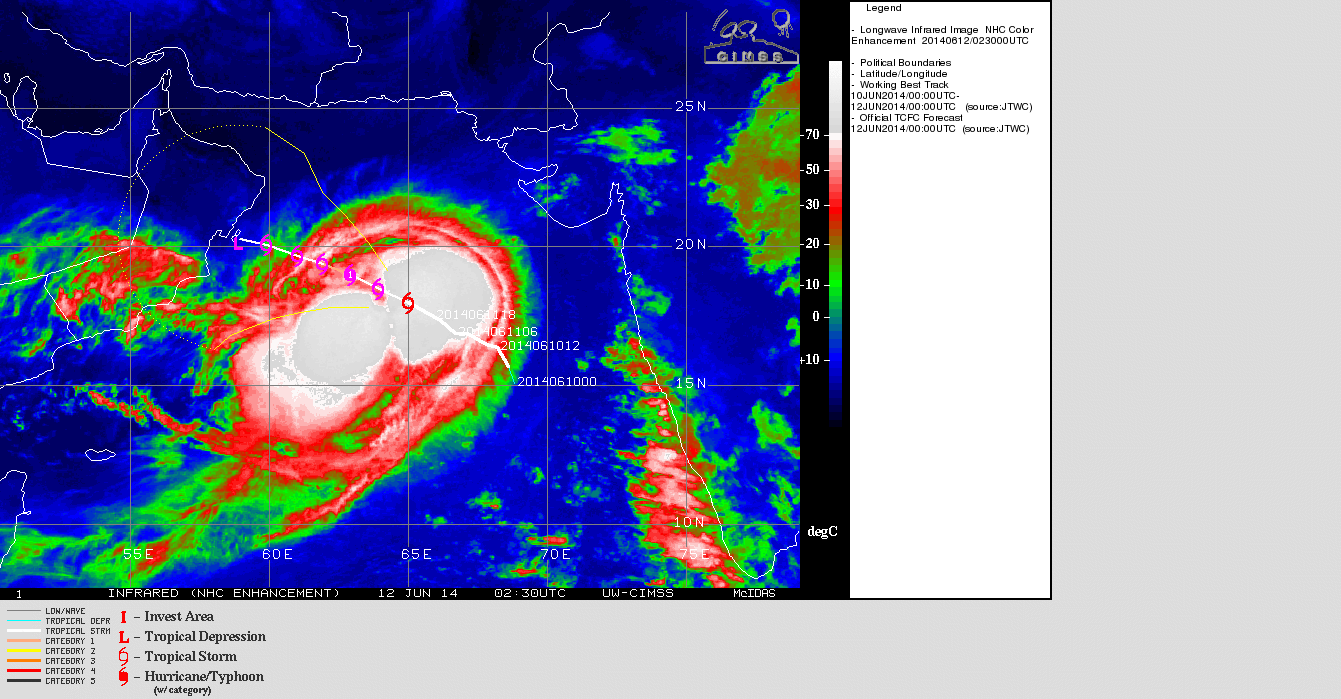
UW-CIMSS IR Satellite Image of 02A (Nanauk) (Cyclonic Storm ‘NANAUK’)
on 12th June @ 0230 UTC
| UW-CIMSS Automated Satellite-Based Advanced Dvorak Technique (ADT) Version 8.2.1 Tropical Cyclone Intensity Estimation Algorithm |
|
| Current Intensity Analysis | |
                     UW - CIMSS
              ADVANCED DVORAK TECHNIQUE
                  ADT-Version 8.2.1
         Tropical Cyclone Intensity Algorithm

             ----- Current Analysis -----
     Date :  12 JUN 2014    Time :   033000 UTC
      Lat :   18:28:09 N     Lon :   63:39:09 E


                         CI# /Pressure/ Vmax
                         4.0 / 974.5mb/ 65.0kt


             Final T#  Adj T#  Raw T#
                3.7     3.4     3.4

 Center Temp : -38.5C    Cloud Region Temp : -66.4C

 Scene Type : EMBEDDED CENTER CLOUD REGION

 Positioning Method : SPIRAL ANALYSIS

 Ocean Basin : INDIAN
 Dvorak CI > MSLP Conversion Used : PACIFIC

 Tno/CI Rules : Constraint Limits : NO LIMIT
                   Weakening Flag : ON
           Rapid Dissipation Flag : OFF

 C/K/Z MSLP Estimate Inputs :
  - Average 34 knot radii :   65km
  - Environmental MSLP    :  999mb

 Satellite Name :    MET7
 Satellite Viewing Angle : 22.9 degrees
|


As per your forcast & map sir ,
How rainy season in the year ?
and sir give your ans aporoxly because i know you are short timely forcast…..
Full year no forecast. Think positive and results will be good. There is no El Nino as yet. Full fledge El Nino reuires many months before being declared and by that time our Monsoon will be over.
Hello Sir,
As per the IMD, it seems that we have a below normal monsoon this year. Is it going to effect Gujarat or Gujarat will receive normal rain falls during the season ?
I am a short term forecaster, so can not through light on your query.
sir, the climate of jamnagar has changed today since morning. There are some black clouds in the sky but I don’t see any chance of rain today.
Sir,
Pre-monsoon movement has started in Gujarat & Saurashtra?
When will monsoon start in MUMBAI?
Yes pre-monsoon in Mararashtra Coastal areas started and now South Gujarat & Saurashtra will receive pre-monsoon rain on daily basis but light and scattered.
સર , ગુજરાત માં વાવની લાયક વરસાદ ક્યારે આવશે .વાવાજોડા પછી
સીસ્ટમ બંધાશે તેમાં સમય કેટલો લાગશે .ચોમાસું ક્યારે ગુજરાત માં
દાખલ થશે.
ચોમાસું મુંબઈ માં એક બે દિવસ માં પોંચી જશે. આપડે ચોમાસા પહેલા ના છૂટા છવાયા ઝાપટા હળવો વરસાદ થશે.
Ashokbhai, there are huge amount of clouds over andaman and bay of benga. Will it reach to gujarat?
Bay of Bengal Clouds can reach Gujarat after the Monsoon sets in over Central India. Once the Axis of Monsoon from Barmer to the Bay of bengal is in places, most of the Bay of Bengal Systems will travel along the Axis. rain can be expected to the Southwest of the System when travelling on the Axis of Monsoon.
Sir panchmahal ma rain na chance che ?
Rain will start from Coastal Saurashtra & South Gujarat and then Panchmahal area.
Sir, due to current system, is there any chances of rain in Kutch?
Initially scattered light rain in Coastal Saurashtra & South Gujarat and then Kutch.
સર ,વેસ્ટ ના પવાનો આવે તો આ સીસ્ટમ આ વે તેવી શક્યતા ખરી ?.
હાલમાં કોડીનાર માં ઘટાદાર વાદળ અને દક્ષિણી પક્ષિમી પવનો
આ વી રહ્યા છે .તો વરસાદની શક્યતા ખરી .?
પ્રશ્ન એક વાર પૂછવો અને જવાબ ની રાહ જોવી.
હા વરસાદ આવશે. વાવાઝોડું દૂર જાય છે.
Gujarat (sabarkantha) ma kyar thi vavani layak varsad ave evi sakya tao 6?
Gujarat (sabarkantha) વરસાદ આવશે પરંતુ વાવણી લાયક માટે હજુ વાર છે.
Su 48 kalak ma monsoon avi jase ava news avi rahiya che su aa vaat sachi che
હા વરસાદ આવશે. મોન્સૂન મુંબઈ માં આવે પછી આપડે આવે.
Sir,su aa nanauk cyclon elnino nu karan chhe.ane aa ni koi negative asar saurashtra ma varsad maa thase
Ane haji cloud kem bov nathi
There is no El Nino at present till now.
આ સીસ્ટમ આપડી બાજુ નથી આવતી એટલે આપડા ભાગ ના વાદળા અને ભેજ અરબી સમુદ્ર માં વર્ષી ગયા.
ફરી વાદળા બંધાશે
hello, ashokbhai do u realy believe that saurashtra will get rain due to cyclone? So far no any positive indication concern to cyclone. Very sad and bearing heat. When the saurashtra vl get rain? Is there any obstacle in monsoon due to this cyclone?
There will be light rain on at least two days by 15th June.
There will be light rain on at least two days by 15th June
Sir,
Thanks for information.
સર પવન ની જડપ ક્યાં સુધી વધશે?અને આ સિષ્ટમ સૌરાષ્ટ્ર તરફ આવવાના CHANSE ખરા?
આ સીસ્ટમ આપડી બાજુ નથી આવતી.
Is any adverce effect of this cyclone on progress of sw monsoon??
Yes huge amount of moisture has been diverted to Central Arabian Sea which would have been beneficial to Western Coast of India.
hello sir,
instability che vratavaran ma? jem tame mane samjavyu hatu.. regading lightning su aa evo varsad rese kadaka vado k normal windy rain…? ane surendranagar ne cover karse varsad k nai?
General light rain scattered rain initially few days and then medium. Most areas will be covered.