Current Weather Conditions on 9th October 2014 @ 8.30 am.
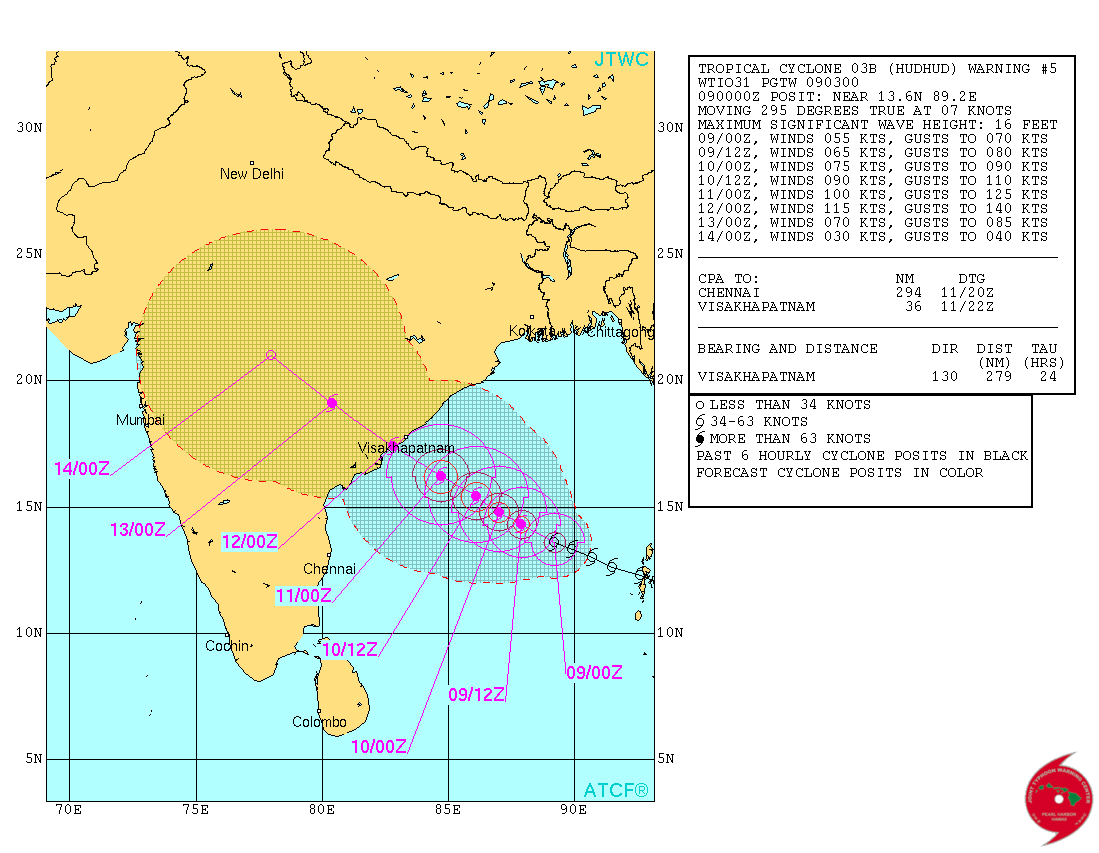
JTWC has isssued Tropical Cyclone Warning Number 5 @ 0300 UTC on 9-10-2014 for conditions at 0000 UTC of 9-10-2014. System 03B.Hudhud had 55 knots wind speed with 982 mb. Central Pressure located at Lat. 13.6°N & Long. 89.2°E over the East Central Bay of Bengal.
JTWC Tropical Cyclone 03B.HUDHUD Warning No. 5
Forecast Cyclone Track
IMD National Bulletin available here
RSMC Bulletin available here
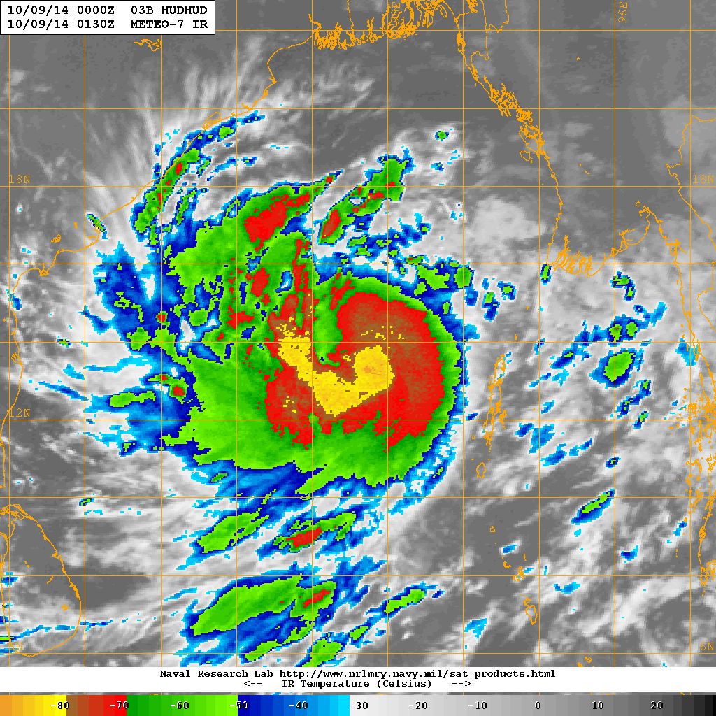
NRL IR Satellite Image of 03B.HUDHUD ( Cyclonic Storm “HUDHUD” )
on 9th October 2014 @ 01.30 UTC (8.00 am. IST )
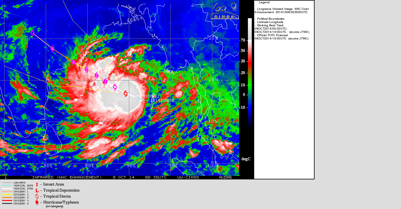
UW-CIMMS IR Satellite Image of 03B.HUDHUD ( Cyclonic Storm “HUDHUD”)
on 9th October 2014 @ 00.30 UTC (6.00 am. IST )
| UW-CIMSS Automated Satellite-Based Advanced Dvorak Technique (ADT) Version 8.2.1 Tropical Cyclone Intensity Estimation Algorithm |
|
| Current Intensity Analysis | |
                     UW - CIMSS
              ADVANCED DVORAK TECHNIQUE
                  ADT-Version 8.2.1
         Tropical Cyclone Intensity Algorithm

             ----- Current Analysis -----
     Date :  09 OCT 2014    Time :   013000 UTC
      Lat :   13:42:07 N     Lon :   89:03:25 E


                CI# /Pressure/ Vmax
                3.7 / 990.8mb/ 59.0kt


             Final T#  Adj T#  Raw T#
                3.7     3.7     3.7

 Center Temp : -68.2C    Cloud Region Temp : -76.2C

 Scene Type : EMBEDDED CENTER CLOUD REGION

 Positioning Method : FORECAST INTERPOLATION

 Ocean Basin : INDIAN
 Dvorak CI > MSLP Conversion Used : PACIFIC

 Tno/CI Rules : Constraint Limits : NO LIMIT
                   Weakening Flag : OFF
           Rapid Dissipation Flag : OFF

 C/K/Z MSLP Estimate Inputs :
  - Average 34 knot radii :   62km
  - Environmental MSLP    : 1009mb

 Satellite Name :    MET7
 Satellite Viewing Angle : 40.1 degrees

****************************************************
|
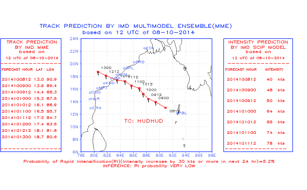
Forecast track by IMD Multimodel Ensemble (MME) Valid 12.00 UTC of 8-10-2014
For NWP Tropical Cyclone Genesis Potential Animation Track of the current System Click here
Forecast: 9th October to 12th October 2014
Cyclonic Storm “HUDHUD” – 03B.HUDHUD:
Cyclonic Storm “HUDHUD”. The System is expected to track mainly West Northwest towards North Andhra Pradesh/South Odisha Coast for next three days. The System is expected to strengthen further to Sever Cyclonic Storm and then to a Very Severe Cyclonic Stom by 11th October. Landfall expected around 12th October vicinity of Vishakhapatnam as per both GSF as well as ECMWF available forecast runs.
Note: Refer/Rely on IMD/RSMC Bulletins/Advisories


Sir hudhud cyclone north west direction ma agal vadhe che to bob tatha arbi ni system mota bhage NW direction ma kem jati hoi che?
Chomasa pachhi, BOB ni System Bangla desh thi mandi ne Tamilnadu taraf jai shake chhe. Je te time na paribad oopar adhaar hoi chhe.
Chomasama Samaya rite NW jati hoi chhe karan ke Chomasu dhari oopar System jaay chhe.
Arabi ma Chomasa pachhi paribado oopar aadhar hoi chhe.
tevij ritey WD pan kyarek asar kare chhe System ne Poorva taraf lai java ma .
Visay gahan chhe, anoobhave khyal pade.
atle hud hud ne karne saurastra ma asar na kare parantu vatavaran bagde(vadal chhayu) avi sakyata khari?
Ha vadada rahe.
Mr.ashokbhai your work for weather analisis over saurashtra is very very good. Many many thank for this help
suarastra ma varasad thase
Hud Hud vavajoda ashar rupe saurashtra ma varsad ni sakyata 6?
Sir almost badha city Rajkot, Ahmedabad, Baroda etc. ma bahu garmi ane bafaro che. Kyak ne kyak mini vavajodu, gaj vij saathe varsad ane bhare pavan fukai che bapor pachi.
Shu aavu jj rehse aa vakhte, varsad ni season gai toi kem aavu chalu jj che haju sudhi.
Thodu detail ma explain karo plz.
varsad to thasej
Sir please you reply.
Hudhud vavazodu Vishakhapatnam, North Andhra aaspaas tratakshe ane Andhra, Odisha, Chhatishgarh, Vidarbh, Poorva M.P. ane Poorva U.P. baju varsad aapshe.
Gujarat ane Saurashtra ne aani khaas asar nahi thai.
Thanks sir pan maro prasna alag che, please eno reply aapso.
Thoda divas vatavaran ma asthirta hati. etle mavathu thayu.
garmi raheshe 12/13 tarikh sudhi. Tapmaan 2 thi 3 degree normal thi oonchu rahe.
Aa garmi kai asamnya nathi.
Hudhudna karane gujaratma varasadni sakyata chhe?
Lagtu nathi bhai.