Current Weather Conditions on 29th October 2014 @ 8.30 am.
For Latest Bulletin from REGIONAL SPECIALISED METEOROLOGICAL CENTRE-TROPICAL CYCLONES, NEW DELHI click here…
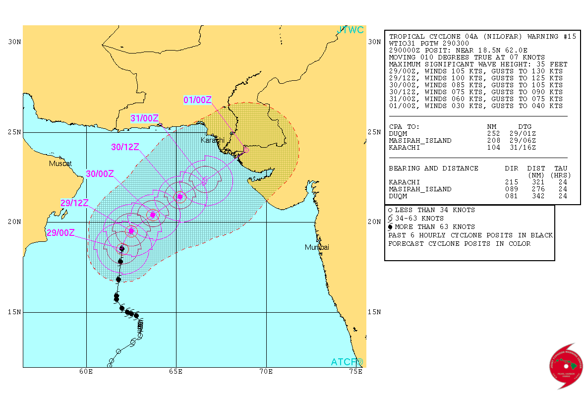
Very Severe Cyclonic Storm ‘NILOFAR’ over West Central Arabian Sea had strengthened to 115 knots (213 kms./hour on 1 min. ave. speed basis) 12 hours ago and has tracked mainly Northwards during the last 12 hours.
Current location at 0000 UTC on 29th October 2014 is Lat. 18.5 N & Long. 62.0 E with 105 knots winds (195 kms./hour on 1 min. ave. speed basis) and 944 mb. Central Pressure. The System has weakened marginally by 10 knots. Wave height of 35 feet.
JTWC Tropical Cyclone Warning No. 15 Dated 29th October 2014 @ 0300 UTC
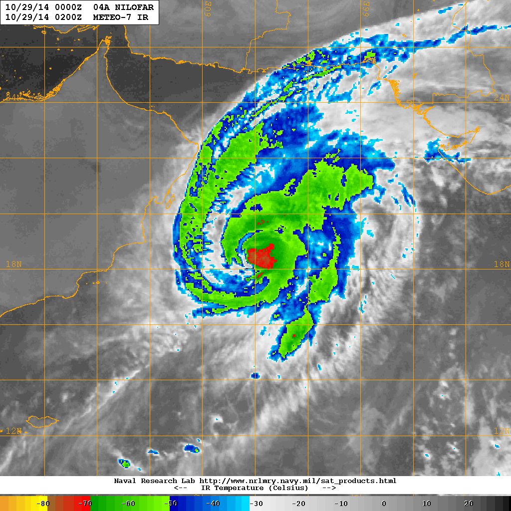
NRL IR Satellite Image of VSCS ‘NILOFAR’
Dated 29th October 2014 @ 0200 UTC
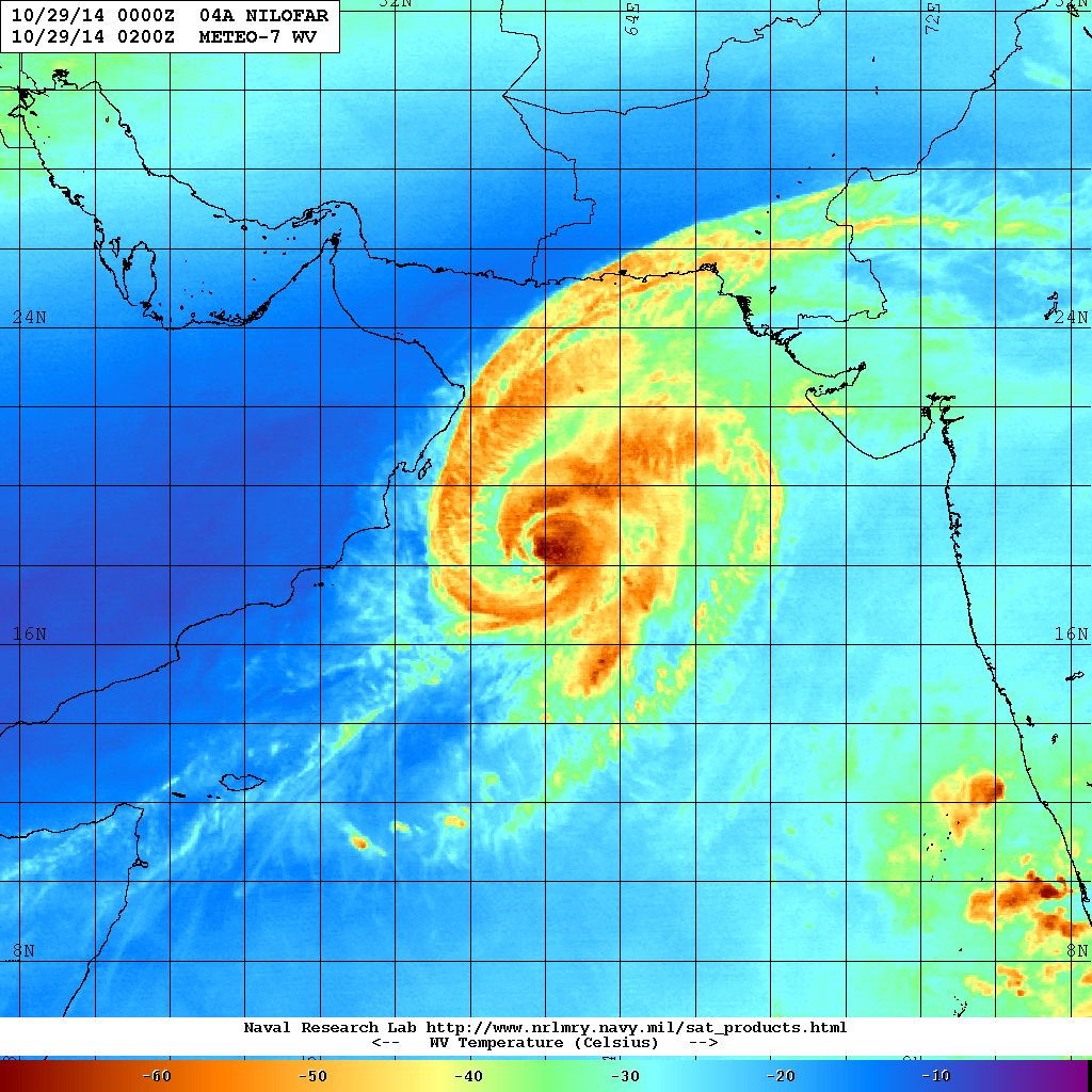
NRL Water Vapor Satellite Image of VSCS ‘NILOFAR’
Dated 29th October 2014 @ 0200 UTC
Forecast: 29th October to 1st November 2014
Both major forecast models GFS & ECMWF have differing outcome for this System.
As per GFS the System is expected to weaken from 30th as it re-curves Eastwards towards Sindh/Kutch/Saurashtra and make landfall on 31st October/1st November as a weak System.
As per ECMWF the System will start weakening from 30th onward as it re_curves Northeast/East and dissipate at sea between 1st/2nd November. This model does not expect the System to make landfall.
VSCS ‘NILOFAR’ is expected to start weakening from now on wards and is expected to weaken daily from now on wards.
There is less confidence in the final outcome as of now so update will be given by night of 29th October 2014.
Caution: Please refer/rely on IMD/RSMC Bulletins/Advisories for Storms & Weather related matter.
આગાહી તારીખ ૨૯ ઓક્ટોબર થી ૧ નવેમ્બર ૨૦૧૪:
મધ્ય પશ્ચિમ અરબી સમુદ્ર માં ‘નીલોફર’ નામનું અતિ તીવ્ર વાવાઝોડું ૧૨ કલાક પહેલા વધુ મજબૂત બનેલ અને ૧૧૫ નોટ ના પવનો ફૂંકતા હતા (૨૧૩ કિમી પ્રતિ કલાક ની ઝડપ ના પવનો જે ૧ મિનીટ ની એવરેજ મૂજબ ) અને ૯૩૭ મિલીબાર પ્રેસર હતું. આ વાવાઝોડા આસપાસ દરિયા ના મોજા ૩૦ ફૂટ ઊંચા ઊછળતા હતા. છેલ્લા ૧૨ કલાક માં સીસ્ટમ ઊત્તર બાજુ ચાલી છે.
આજે તારીખ ૨૯ ઓક્ટોબર 0000 UTC (05.30 am. IST ) ના‘નીલોફર’ નામનું અતિ તીવ્ર વાવાઝોડું Lat.18.5 N & Long. 62.0 E ઉપર કેન્દ્રિત હતું. પવનો ૧0૫ નોટ (૧૯૫ કિમી પ્રતિ કલાક ની ઝડપ ના પવનો જે ૧ મિનીટ ની એવરેજ મૂજબ ) અને ૯૪૪ મિલીબાર પ્રેસર છે. આ વાવાઝોડા આસપાસ દરિયા ના મોજા ૩૫ ફૂટ ઊંચા ઊછળે છે. આ સીસ્ટમ સામાન્ય નબળી પડી છે. ૧૨ થી ૨૪ કલાક માં સીસ્ટમ નબળી પડવાનું ચાલુ રાખશે અને ત્યાર બાદ એક બે દિવસ વધુ નબળી પડશે.
આ સીસ્ટમના ભાવી અંગે હજુ ચોક્સાય કરવી પડે તેમ હોઈ આજે રાત્રે અપડેટ કરવામાં આવશે.
સૌરાષ્ટ્ર ગુજરાત અને કચ્છ માં સાવચેતી રાખવી કારણ કે પવન થી અને વરસાદ થી નૂકસાન થવાની શક્યતા થઇ શકે.
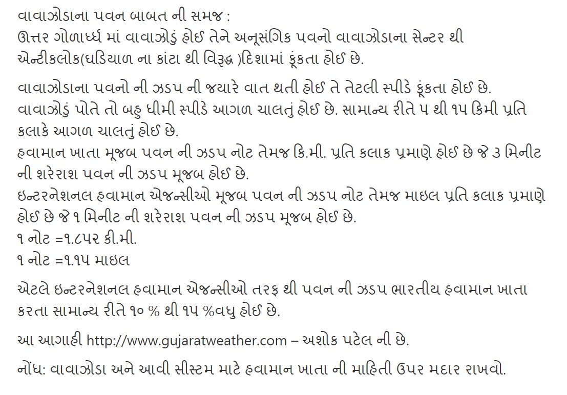
વાવાઝોડાના પવન બાબત ની સમજ :
ઊત્તર ગોળાર્ધ્ધ માં વાવાઝોડું હોઈ તેને અનૂસંગિક પવનો વાવાઝોડાના સેન્ટર થી એન્ટીકલોક(ઘડિયાળ ના કાંટા થી વિરૂદ્ધ )દિશામાં ફૂંકતા હોઈ છે.
વાવાઝોડાના પવનો ની ઝડપ ની જયારે વાત થતી હોઈ તે તેટલી સ્પીડે ફૂંકતા હોઈ છે.
વાવાઝોડું પોતે તો બહુ ધીમી સ્પીડે આગળ ચાલતું હોઈ છે. સામાન્ય રીતે ૫ થી ૧૫ કિમી પ્રતિ કલાકે આગળ ચાલતું હોઈ છે.
હવામાન ખાતા મૂજબ પવન ની ઝડપ નોટ તેમજ કિ.મી. પ્રતિ કલાક પ્રમાણે હોઈ છે જે ૩ મિનીટ ની શરેરાશ પવન ની ઝડપ મૂજબ હોઈ છે.
ઇન્ટરનેશનલ હવામાન એજન્સીઓ મૂજબ પવન ની ઝડપ નોટ તેમજ માઇલ પ્રતિ કલાક પ્રમાણે હોઈ છે જે ૧ મિનીટ ની શરેરાશ પવન ની ઝડપ મૂજબ હોઈ છે.
૧ નોટ =૧.૮૫૨ કી.મી.
૧ નોટ =૧.૧૫ માઇલ
એટલે ઇન્ટરનેશનલ હવામાન એજન્સીઓ તરફ થી પવન ની ઝડપ ભારતીય હવામાન ખાતા કરતા સામાન્ય રીતે ૧૦ % થી ૧૫ %વધુ હોઈ છે.
આ આગાહી http://www.gujaratweather.com – અશોક પટેલ ની છે.
નોંધ: વાવાઝોડા અને આવી સીસ્ટમ માટે હવામાન ખાતા ની માહિતી ઉપર મદાર રાખવો.
00votes
Article Rating
27 Add your comment here
Inline Feedbacks
View all comments
siddharth bamrotiya
29/10/2014 8:24 pm
sir loej taluko mangrol junagtha ma kevo varshad ane vavazodu thase
DHARMESH
29/10/2014 7:29 pm
Sir ,
Please update
Bipin patel
29/10/2014 7:21 pm
Sir vavajoda thi saurastra ma varsad ketlo aav se
Suresh odedara
29/10/2014 6:25 pm
Sir nilofan jamnagar kyare pahose
Nirul Gothi
29/10/2014 6:25 pm
Sir in sat pic indicate that nilofer is moving towards north east direction and will hit saurashtra coast prob towards porbander sea coast will it happens
chhatrapal shih .m.jadeja
29/10/2014 6:23 pm
Jay mataji sir
Upaleta baju varsad aav vani ketali sakiyata Che ? ?
bharat ahir chakhava
29/10/2014 5:35 pm
Mangrol (jnd) ma vavajodu aavse?
Raj
29/10/2014 4:54 pm
Sir, what would be effect of this cyclone in Ahmedabad and surroundings…please reply.
vipul sakriya
29/10/2014 4:39 pm
Botad ma avvani sakyta se ke nhi plzz riply sir
pandya dinkar Rajpar
29/10/2014 3:38 pm
sir morbi na ajubaju na vistar ma vavajoda ke varsad ni kevi asar thase
Very well explained.. ,….unfortunatly readers do not understsnd these and keep asking ” Rajkot asvshe?. …varsad aavshe?.”…..funny.. …Thanx Ashokbhai.. …..
Hemendra Ghatodiya
29/10/2014 9:52 am
Good morning sir,
Jamnagar par pavan & vars ad ni ketli sabhavna se
vadecha bharat
29/10/2014 9:41 am
Sir kutch ( kandla ) ma heavy rain na chance che ?
raju pithiya
29/10/2014 9:21 am
thenks sir.
meet patel
29/10/2014 9:14 am
Sir mane janav so ke anand ma varsad ane pavan avse ke nai
Yashpalsinh
29/10/2014 9:06 am
Sir Rajkot ma varshad aav vani shmbhavna 6 k kem
Niraj Patel
29/10/2014 8:49 am
Sir aa system thi central gujarat ma varsad thava ni sambhavana kari..???
paurav
29/10/2014 8:47 am
Seems like no landfall for nilofar.2nd one is right.satallite pics shows reduced diameter of red spot and overall diameter too
raju pithiya
29/10/2014 8:35 am
sir,” samany rite evu kahevay ke vavajodu jetlo vadhare samay dariya ma rahe tetlu vadhare khatrnak banne” to aa babte tamaru su manvu che?
sir loej taluko mangrol junagtha ma kevo varshad ane vavazodu thase
Sir ,
Please update
Sir vavajoda thi saurastra ma varsad ketlo aav se
Sir nilofan jamnagar kyare pahose
Sir in sat pic indicate that nilofer is moving towards north east direction and will hit saurashtra coast prob towards porbander sea coast will it happens
Jay mataji sir
Upaleta baju varsad aav vani ketali sakiyata Che ? ?
Mangrol (jnd) ma vavajodu aavse?
Sir, what would be effect of this cyclone in Ahmedabad and surroundings…please reply.
Botad ma avvani sakyta se ke nhi plzz riply sir
sir morbi na ajubaju na vistar ma vavajoda ke varsad ni kevi asar thase
Sir. .
Gadhada( swamina) DISTRICT. .botad..
2.3 .diwas ma varshad kevo rhese
Ketla “Inc” thaaae varshad
rajkot ma varsad aavse k nahi
Rajkot mate koi bhayankta vadhu che?
Rajkot ma ketli effect avse
khedu ni ung haram kari ho nilofare to
Sir nilofar gujarat pase avse tyare speed ketli hase
Sir nilofar nablu padavanu karan su che
vavazoda thi jamnagar thi rajkot baju ketala vistar ma varasad padse ane kyare padse
Very well explained.. ,….unfortunatly readers do not understsnd these and keep asking ” Rajkot asvshe?. …varsad aavshe?.”…..funny.. …Thanx Ashokbhai.. …..
Good morning sir,
Jamnagar par pavan & vars ad ni ketli sabhavna se
Sir kutch ( kandla ) ma heavy rain na chance che ?
thenks sir.
Sir mane janav so ke anand ma varsad ane pavan avse ke nai
Sir Rajkot ma varshad aav vani shmbhavna 6 k kem
Sir aa system thi central gujarat ma varsad thava ni sambhavana kari..???
Seems like no landfall for nilofar.2nd one is right.satallite pics shows reduced diameter of red spot and overall diameter too
sir,” samany rite evu kahevay ke vavajodu jetlo vadhare samay dariya ma rahe tetlu vadhare khatrnak banne” to aa babte tamaru su manvu che?
Jyan sudhi yogya paribad madey tyan sudhi majboot bane. Aa Sytem nabadi padvanu chalu thayu chhe.