Current Weather Conditions on 30th October 2014 @ 8.30 am.
For Latest Bulletin from REGIONAL SPECIALISED METEOROLOGICAL CENTRE-TROPICAL CYCLONES, NEW DELHI click here…
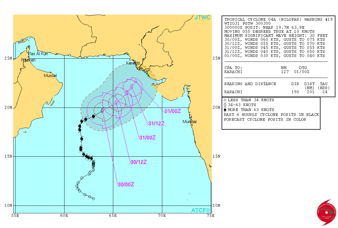
Very Severe Cyclonic Storm ‘NILOFAR’ over West Central Arabian Sea has weakened considerably from its peak of 115 knots (213 kms./hour on 1 minute average speed basis) on 28th October to 60 knots (111 kms./hour on 1 minute average basis)
Current location at 0000 UTC on 30th October 2014 is Lat. 19.7 N & Long. 63.9 E with 60 knots winds (111 kms./hour on 1 minute average speed basis) and 978 mb. Central Pressure. The System has weakened by 65 knots from its peak. Wave height of 30 feet.
Tropical Cyclone 04A (Nilofar) Warning #19 Issued at 30/0300Z
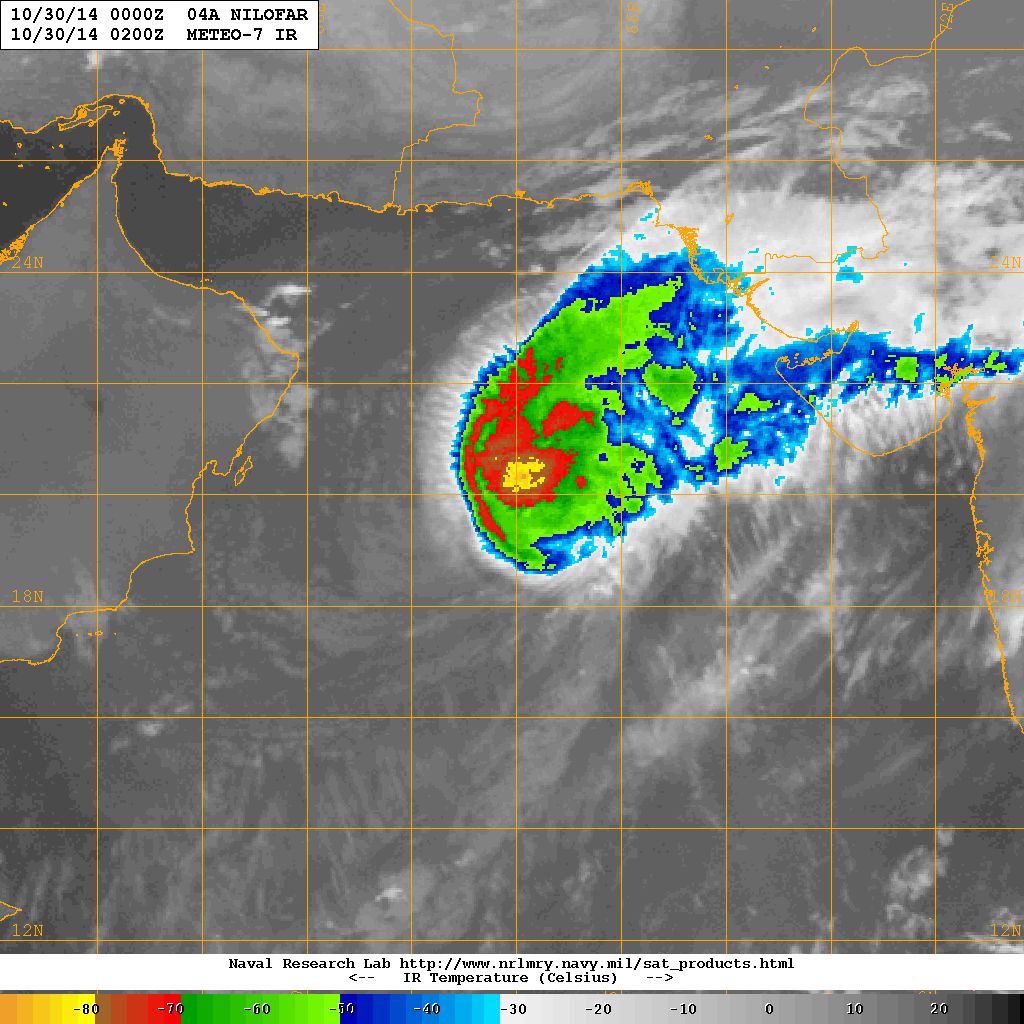
NRL IR Satellite Image of 04A.NILOFAR
Dated 30th October 2014 @ 0200 UTC
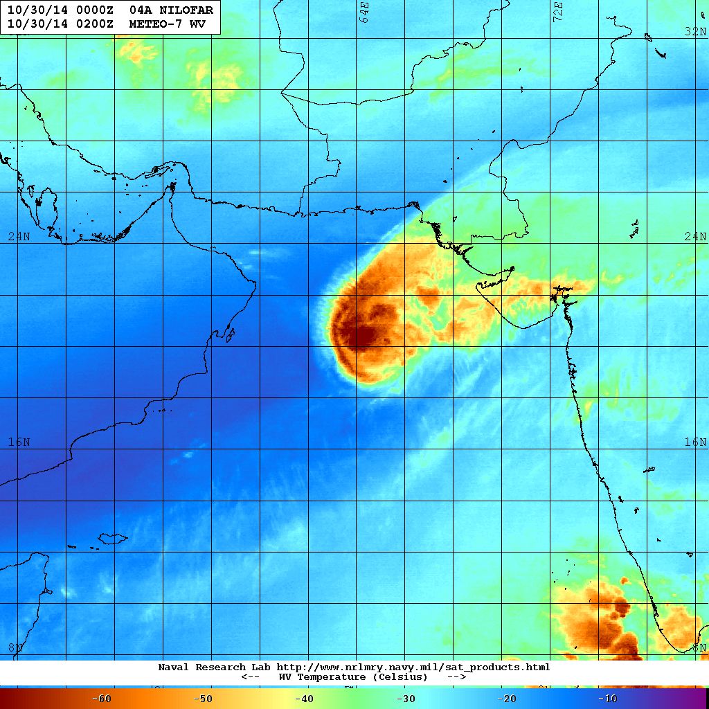
NRL Water Vapor Satellite Image of 04A.NILOFAR
Dated 30th October 2014 @ 0200 UTC
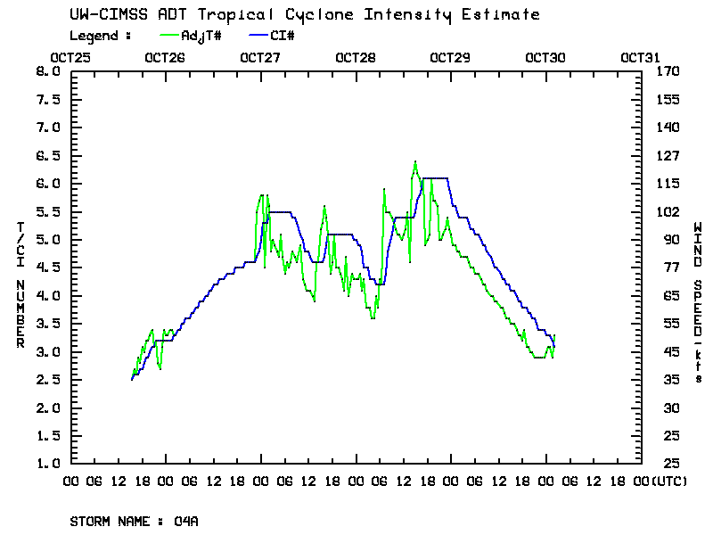
| UW-CIMSS Automated Satellite-Based Advanced Dvorak Technique (ADT) Version 8.2.1 Tropical Cyclone Intensity Estimation Algorithm | |
| Current Intensity Analysis | |
                     UW - CIMSS
              ADVANCED DVORAK TECHNIQUE
                  ADT-Version 8.2.1
         Tropical Cyclone Intensity Algorithm

             ----- Current Analysis -----
     Date :  30 OCT 2014    Time :   020000 UTC
      Lat :   19:50:06 N     Lon :   64:10:19 E


                CI# /Pressure/ Vmax
                3.1 / 995.2mb/ 47.0kt


             Final T#  Adj T#  Raw T#
                3.0     3.3     3.3

 Center Temp : -52.0C    Cloud Region Temp : -66.2C

 Scene Type : EMBEDDED CENTER CLOUD REGION

 Positioning Method : FORECAST INTERPOLATION

 Ocean Basin : INDIAN
 Dvorak CI > MSLP Conversion Used : PACIFIC

 Tno/CI Rules : Constraint Limits : NO LIMIT
                   Weakening Flag : ON
           Rapid Dissipation Flag : ON

 C/K/Z MSLP Estimate Inputs :
  - Average 34 knot radii :  100km
  - Environmental MSLP    : 1009mb

 Satellite Name :    MET7
 Satellite Viewing Angle : 24.6 degrees

****************************************************
|
04A.NILOFAR
Forecast: 30th October to 2nd November 2014
Both major forecast models GFS & ECMWF do not expect the System to make landfall, however, both have differing outcome for distance to landfall.
As per GFS the System has started weakening and is expected to weaken considerably by 31st as it reaches vicinity of Saurashtra & Kutch and remain there for two days till 2nd November. As per last forecast runs this model also does not expect System to make landfall.
As per ECMWF the System has started weakening and is expected to remain far from Kutch & Saurashtra and dissipate at sea by 2nd November. This model does not expect the System to make landfall.
One thing is certain as per all models that the System is expected to weaken considerably during the next 48 hours. System not expected to make landfall even though it would be in the vicinity of Saurashtra & Kutch. Clouding associated with the System will be over Saurashtra, Kutch & Gujarat and adjoining Northeast Arabian Sea till 2nd November. Scattered showers, light to medium rainfall is expected over parts of Saurashtra & Kutch with isolated heavy rainfall over Kutch and Coastal areas of Saurashtra till 2nd November. Since the System is expected to weaken winds will be lower than expected earlier.
Caution: Please refer/rely on IMD/RSMC Bulletins/Advisories for Storms & Weather related matter.
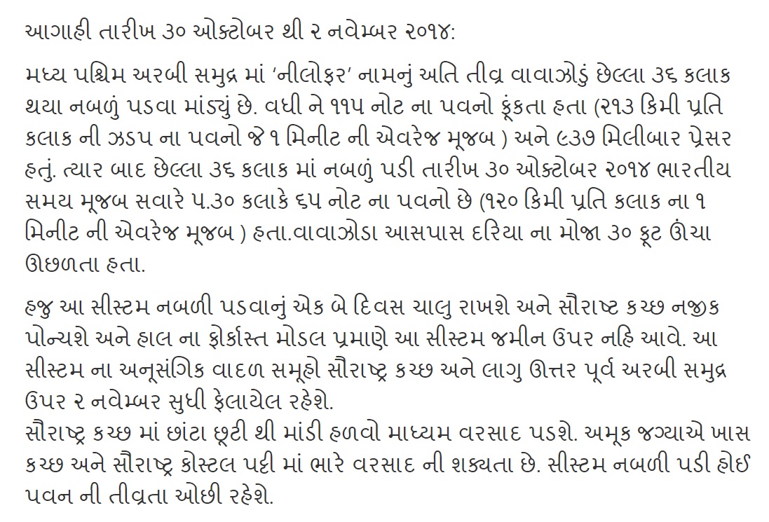
આગાહી તારીખ ૩૦ ઓક્ટોબર થી ૨ નવેમ્બર ૨૦૧૪:
મધ્ય પશ્ચિમ અરબી સમુદ્ર માં ‘નીલોફર’ નામનું અતિ તીવ્ર વાવાઝોડું છેલ્લા ૩૬ કલાક થયા નબળું પડવા માંડ્યું છે. વધી ને ૧૧૫ નોટ ના પવનો ફૂંકતા હતા (૨૧૩ કિમી પ્રતિ કલાક ની ઝડપ ના પવનો જે ૧ મિનીટ ની એવરેજ મૂજબ ) અને ૯૩૭ મિલીબાર પ્રેસર હતું. ત્યાર બાદ છેલ્લા ૩૬ કલાક માં નબળું પડી તારીખ ૩૦ ઓક્ટોબર ૨૦૧૪ ભારતીય સમય મૂજબ સવારે ૫.૩૦ કલાકે ૬૦ નોટ ના પવનો છે (૧૧૧ કિમી પ્રતિ કલાક ના ૧ મિનીટ ની એવરેજ મૂજબ ) હતા.વાવાઝોડા આસપાસ દરિયા ના મોજા ૩૦ ફૂટ ઊંચા ઊછળતા હતા.
હજુ આ સીસ્ટમ નબળી પડવાનું એક બે દિવસ ચાલુ રાખશે અને સૌરાષ્ટ કચ્છ નજીક પોન્ચશે અને હાલ ના ફોર્કાસ્ત મોડલ પ્રમાણે આ સીસ્ટમ જમીન ઉપર નહિ આવે. આ સીસ્ટમ ના અનૂસંગિક વાદળ સમૂહો સૌરાષ્ટ્ર કચ્છ અને લાગુ ઊત્તર પૂર્વ અરબી સમુદ્ર ઉપર ૨ નવેમ્બર સુધી ફેલાયેલ રહેશે. સૌરાષ્ટ્ર કચ્છ માં છાંટા છૂટી થી માંડી હળવો માધ્યમ વરસાદ પડશે. અમૂક જગ્યાએ ખાસ કચ્છ અને સૌરાષ્ટ્ર કોસ્ટલ પટ્ટી માં ભારે વરસાદ ની શક્યતા છે. સીસ્ટમ નબળી પડી હોઈ પવન ની તીવ્રતા ઓછી રહેશે.
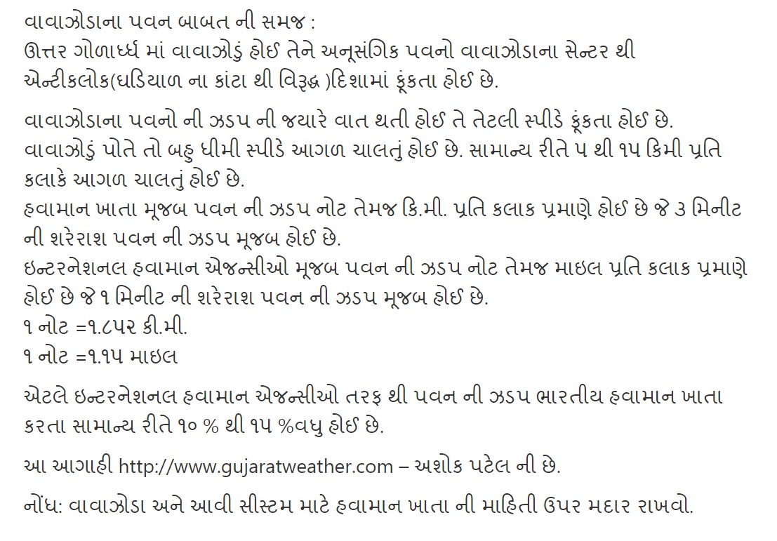
વાવાઝોડાના પવન બાબત ની સમજ :
ઊત્તર ગોળાર્ધ્ધ માં વાવાઝોડું હોઈ તેને અનૂસંગિક પવનો વાવાઝોડાના સેન્ટર થી એન્ટીકલોક(ઘડિયાળ ના કાંટા થી વિરૂદ્ધ )દિશામાં ફૂંકતા હોઈ છે.
વાવાઝોડાના પવનો ની ઝડપ ની જયારે વાત થતી હોઈ તે તેટલી સ્પીડે ફૂંકતા હોઈ છે. વાવાઝોડું પોતે તો બહુ ધીમી સ્પીડે આગળ ચાલતું હોઈ છે. સામાન્ય રીતે ૫ થી ૧૫ કિમી પ્રતિ કલાકે આગળ ચાલતું હોઈ છે. હવામાન ખાતા મૂજબ પવન ની ઝડપ નોટ તેમજ કિ.મી. પ્રતિ કલાક પ્રમાણે હોઈ છે જે ૩ મિનીટ ની શરેરાશ પવન ની ઝડપ મૂજબ હોઈ છે. ઇન્ટરનેશનલ હવામાન એજન્સીઓ મૂજબ પવન ની ઝડપ નોટ તેમજ માઇલ પ્રતિ કલાક પ્રમાણે હોઈ છે જે ૧ મિનીટ ની શરેરાશ પવન ની ઝડપ મૂજબ હોઈ છે. ૧ નોટ =૧.૮૫૨ કી.મી. ૧ નોટ =૧.૧૫ માઇલ
એટલે ઇન્ટરનેશનલ હવામાન એજન્સીઓ તરફ થી પવન ની ઝડપ ભારતીય હવામાન ખાતા કરતા સામાન્ય રીતે ૧૦ % થી ૧૫ %વધુ હોઈ છે.
આ આગાહી http://www.gujaratweather.com – અશોક પટેલ ની છે.
નોંધ: વાવાઝોડા અને આવી સીસ્ટમ માટે હવામાન ખાતા ની માહિતી ઉપર મદાર રાખવો.
aatayre Ketala in jadape pavan fukay che
Hello sir
. as surendranagar na patdi amare tya kem khasedya hase sir surendranagar ne asar thase k Su? And surendranagar ma Tamara hisabe kevo varsad rese?
System adharit varsad no kai netho na hoi.
sir….Coastal areas of Saurashtra …aetle kayo vistar ma vadhare varshad thay
Saurashtra no pashchim kinaro & kutch
Cyclone nilofar 30 Oct midnight na aav se k 31 Oct midnight
Gujarati ma lakhel chhe vancho mara bhai su lakhel chhe te.
Rajkot ma varsad thase?
sir imd ma to 5 tarikh aaspas biju cayclon jevu boba natave
sir haju to arbi samudra ma cayclon puru nathi tayu tyato imd ma to navu bob ma 5 thi 6 tarikh ma cayclon batave to su aatla najik na samay ma kem taya kare sir.
thank’s god
vavazodu gayu has
kapas bachi gayo
khub khub abhar ashokbhai
1 date ma 2 time mahiti apava badal abhar
samast khedut varg tarafthi tamaro khub khub abhar
sir kesod kostak visitama avi ke kem
Varsad bhale aave pan
pavan na aave saru
Sir final have anand ma varsad ke pavan nahi ave pls rply mee
Jay mataji
Dear sir.
Made jiru nu vavetar Kara vuche to hu banana rah jovu Ke nahi ?
Sir ketlo varsad padse
Thanks Ashokbhai.. For timly forecast.. This is very helpfull to Farmers and others also… This is the pick time to collect crop from Farm … So we can take precaution to save them ….. Thanks Again…
Sir,gujrat ma kevok.varsad padse
Sir, Bhuj ma bhare varsad ni shakyata khari aa system ne lidhe?
Himatnagar vistar ma varsad ni sakyata nahivat 6? Jo varsad na avano hoy to khetina kam agal chale …..
Sir aaji-3 full thase
Sir saurastra ma aa vavajodu kevik asar karae…???⛅
Gujarati malakhel chhe vancho
Sir,thanks for good news
bhare barsad atle ketla cemi?