Current Weather Conditions on 5th November 2012 @ 8.00 am.
Cyclonic Storm “NILAM” crossed the North Tamilnadu Coast near Mahabalipuram on 31st October around 5.00 pm. System had weakened to a Depression when it reached South Interior Karnataka and neighborhood on 1st November. By 2nd November 5.30 am. the system had further weakened to a Well Marked Low Pressure over South Interior Karnataka and adjoining area of Rayalseema and on the same day it further weakened to a Low Pressure area and lay over Rayalseema and neighborhood. By 3rd November 5.30 am. it lay over Telangana and neighborhood and by 4th November 5.30 am. it lay over the Coastal areas of Andhra Pradesh.
Here is a chronology of strength and location of the remnant of Cyclonic Storm “NILAM” as monitored by IMD. It can be construed that the system is yet active as a Low Pressure System.
1st November 2012 5.30 pm IST
The depression over south interior Karnataka and neighbourhood remained practically
stationary and lay centred at 1730 hours IST of today, the 1st November 2012 centered lat.
14.0°N and Lon. 76.5 °E, near Chitradurga. The system would move slowly northwestwards and weaken further into a low pressure area during next 12 hours.
2nd November 2012 5.30 am. IST
The depression over south interior Karnataka and neighbourhood weakened into a well
marked low pressure area and lay centred at 0530 hours IST of today, the 2nd November 2012 over south interior Karnataka and adjoining area of Rayalaseema and weaken gradually during next 12 hours.
2nd November 2012 8.30 am IST
The well marked low pressure area over south interior Karnataka and adjoining area of
Rayalaseema weaken further into a low pressure area and lies over Rayalaseema &
neighbourhood at 0830 hours IST of today the 2nd November 2012. The associated upper air circulation extends upto mid tropospheric levels.
3rd November 2012 5.30 am IST
The low pressure area over Rayalaseema & neighbourhood now lies over
Telengana and neighbourhood. The associated upper air cyclonic circulation extends
upto mid tropospheric levels.
4th November 2012 5.30 am IST
The low pressure area now lies over north coastal Andhra Pradesh and neighbourhood
associated with upper air cyclonic circulation extends upto 2.1 km above mean sea level with trough aloft upto mid tropospheric levels.
( IMD chronology over )
JTWC was monitoring this System originally as 93W.INVEST, subsequently as 02B.NILAM which they stopped monitoring on 2nd November when the System was a Low Pressure over land.
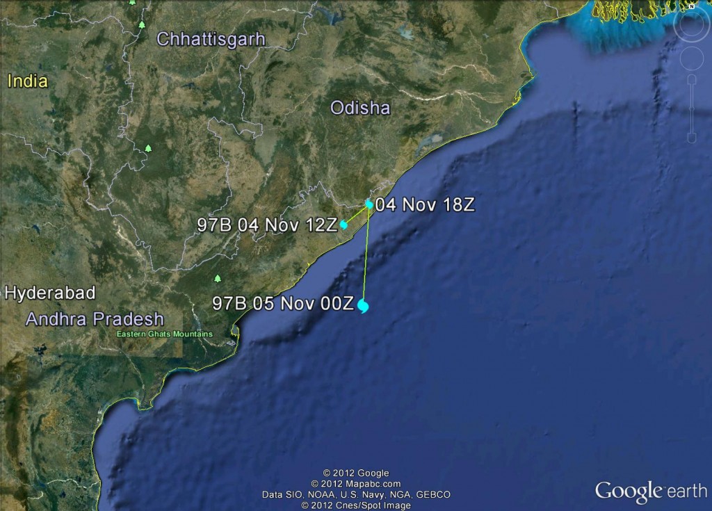
on 4th November 1113 UTC, JTWC started monitoring an area of convection near Coastal Andhra Pradesh as 97B.INVEST. (This is the same Low Pressure area over Coastal Andhra Pradesh that IMD has been tracking as remnant of “NILAM”)
Track of 97B.INVEST – Low Pressure Area
Also on 4th November 2000 UTC JTWC started monitoring an area of convection in Southern Hemisphere but very close to the Equator at 3.2S and 67.7E. as 93S.INVEST. Since this Convection is close to the Equator it needs to be observed.
