21st June 2013 @ 8.00 pm.
Note: This post will be edited as and when extra inputs or further analysis is available.
There has been a Mayhem of destruction in Uttarakhand due to unprecedented heavy rainfall over a very large area of the State and its adjoining areas during 15th to 17th June 2013. Heavier intensity rainfall was over the Chardham area of the State viz. Kedarnath, Badrinath, Gangotri, Yamnotri apart from Rudraprayag, Srinagar, Chamoli, Guarikund and many more places en route to these centers.
Here is an attempt to analyze what could have happened and the reason for the Mayhem and destruction that has unfolded in the last few days in Uttarakhand.
Rainfall Data Of Uttarakhand Districts as per IMD up to 19th June 2013
| DISTRICTWISE RAINFALL DISTRIBUTION | ||||||||
| 01.06.2013 | TO | 19.06.2013 | ||||||
| STATE/UT/MET.SUBDIVISION | ACTUAL | NORMAL | %DEP | CAT. | ||||
| DISTRICT (NAME) | (mm) | (mm) | ||||||
| STATE: UTTARAKHAND | ||||||||
| 1 | ALMORA | 234.4 | 67.1 | 249% | E | |||
| 2 | BAGESHWAR | 455.7 | 67.1 | 579% | E | |||
| 3 | CHAMOLI | 375.6 | 52.5 | 615% | E | |||
| 4 | CHAMPAWAT | 427.0 | 85.7 | 398% | E | |||
| 5 | DEHRADUN | 644.5 | 75.0 | 759% | E | |||
| 6 | GARHWAL PAURI | 205.1 | 43.9 | 367% | E | |||
| 7 | GARHWAL TEHRI | 356.9 | 61.0 | 485% | E | |||
| 8 | HARDWAR | 342.7 | 47.9 | 615% | E | |||
| 9 | NAINITAL | 586.2 | 89.8 | 553% | E | |||
| 10 | PITHORAGARH | 320.3 | 154.2 | 108% | E | |||
| 11 | RUDRAPRAYAG | 479.5 | 102.8 | 366% | E | |||
| 12 | UDHAM SINGH NAGAR | 206.5 | 70.9 | 191% | E | |||
| 13 | UTTARKASHI | 475.9 | 66.1 | 620% | E | |||
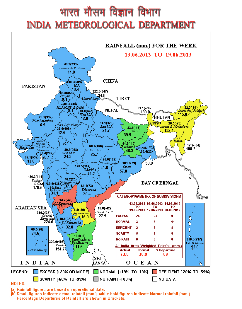
IMD Map showing 322 mm. of Rainfall over Uttarakhand during the week 13-06-2013 to 19-06-2013 (847% of Normal for Uttarakhand for this period)
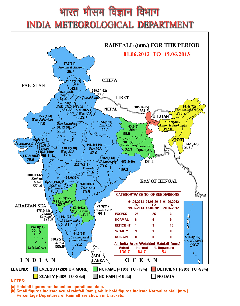
IMD Map showing 389.2 mm. of Rainfall over Uttarakhand up to 19-06-2013 (402 % of normal for Uttarakhand up to this period)
Now we will compare these data with Data from some International Sources.
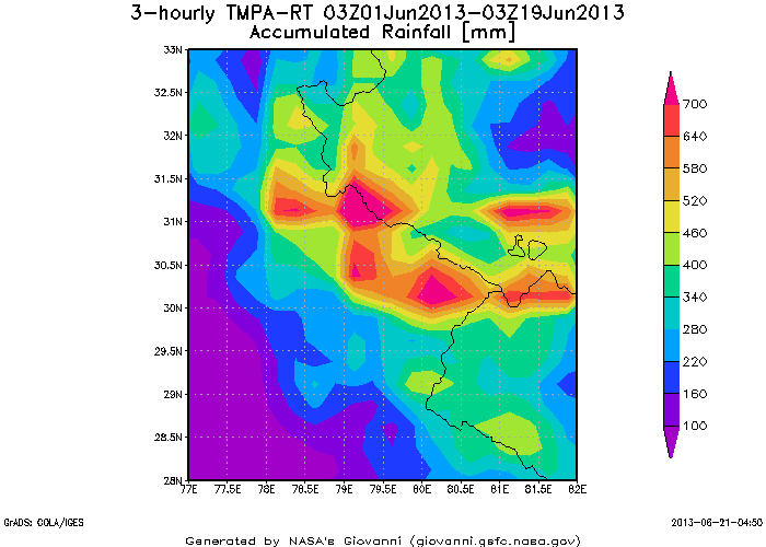
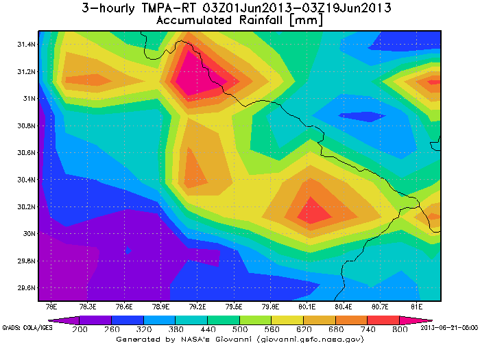
Experimental Real-Time TRMM Multi-Satellite Precipitation Analysis (TMPA-RT): 3B42R
Map Showing Accumulated Rainfall From 1st June to 19th June 2013
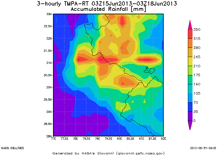
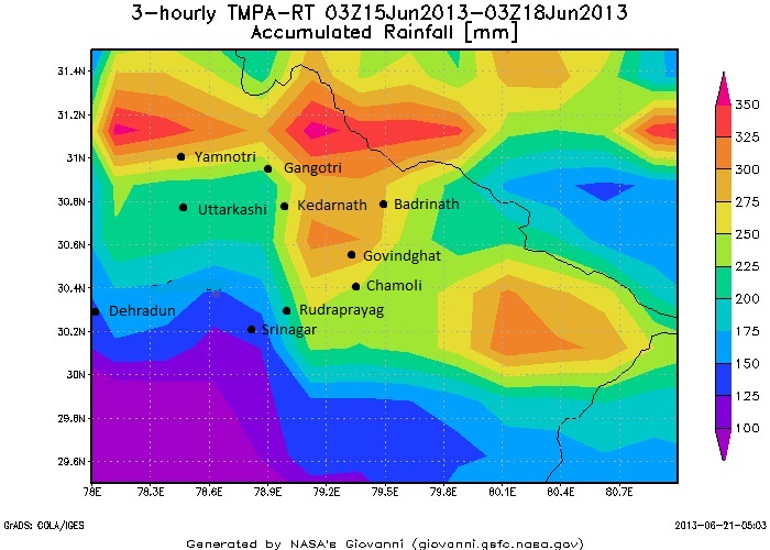
Experimental Real-Time TRMM Multi-Satellite Precipitation Analysis (TMPA-RT): 3B42RT
Map Showing Accumulated Rainfall During the Recent Nature Fury From 15th June to 18th June 2013
Experimental Real-Time TRMM Multi-Satellite Precipitation Analysis (TMPA-RT): 3B42RT
Map Showing Accumulated Rainfall Over Chardham Area From 1st June to 19th June 2013
Experimental Real-Time TRMM Multi-Satellite Precipitation Analysis (TMPA-RT): 3B42RT
Map Showing Accumulated Rainfall Over Chardham Area During Nature’s Fury From 15th June to 18th June 2013
Note: “The images and data used in this study were acquired using the GES-DISC Interactive Online Visualization ANd aNalysis Infrastructure (Giovanni) as part of the NASA’s Goddard Earth Sciences (GES) Data and Information Services Center (DISC).”
What we observe is that there was substantial rainfall between 1st June & 15th June 2013 before the extremely heavy rainfall on two days between 15th June & 18th June. Maps show that there was an average rainfall of 300 mm. between 15th & 18th June over the Northern parts of the State. This is mainly the area covered by the Chardham Pilgrimage being 50 % area of the State of Uttarakhand that covers 51125 Square Kms. In short we are dealing with very heavy rainfall over an area of about 25000 Square Kms. in the most hilly terrains of the State within just two days. The quantum of rain flooded all the rivers of Uttarakhand beyond comprehension.
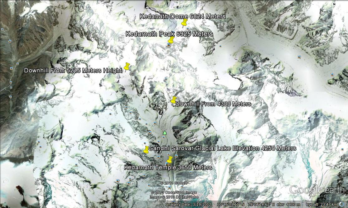
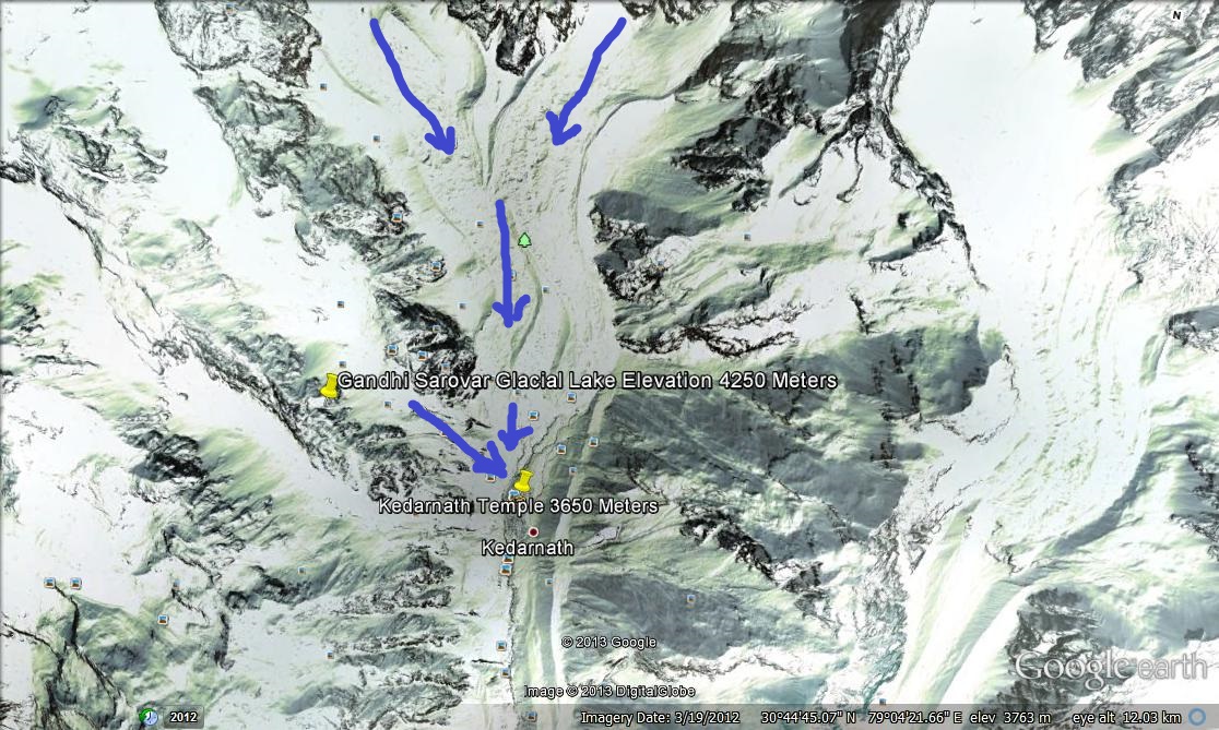
Google Map showing Location and Elevation of Kedarnath Dome, Kedarnath Mountain Peak and Two Slopes on its Southern side leading towards the Kedarnath Temple along with Slope from the Gandhi Sarovar -Glacial Lake.
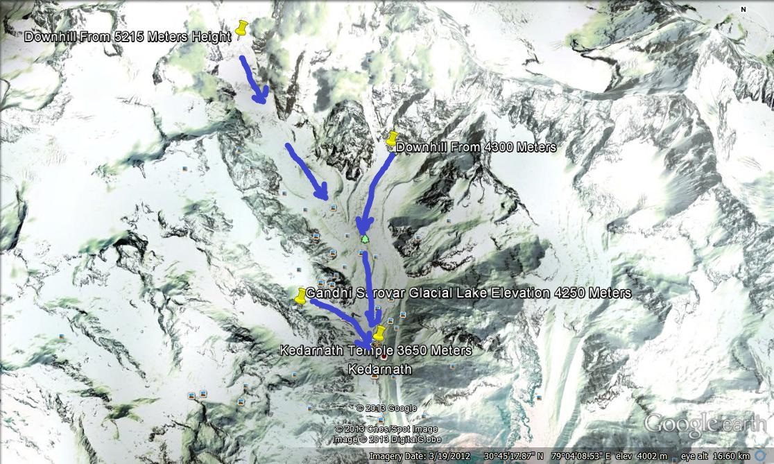
Two Slopes on the Southern side of Kedarnath Peak and Slope from the Gandhi Sarovar -Glacial Lake from where the avalanche & landslide and heavy rain deluge could have led towards the Kedarnath Temple.
Google Map showing Closeup Location of Two Slopes leading towards the Kedarnath Temple along with Slope from the Gandhi Sarovar.
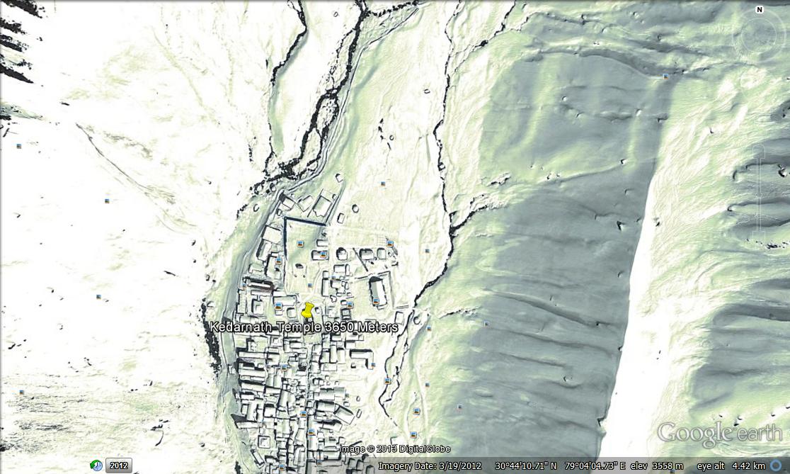
Google Map showing Closeup of the Kedarnath Temple.
The above Google Maps show the location of the Kedarnath Mountain Peak elevation of 6925 Meters, the Kedarnath Dome elevation 6824 Meters, the two slopes starting at elevation 5215 Meters & 4300 Meters leading towards the Kedarnath Temple at about 3650 Meters. One more Slope from the Gandhi Sarovar Glacial Lake elevation 4250 Meters also leads towards the Kedarnath Temple. By observing the above maps and terrain in the vicinity of the Temple we see that the Kedarnath Peak and the Kedarnath Dome are the high points of this area. Southwards of the Kedarnath Peak are two slopes both leading down towards the Kedarnath Temple along with a Slope from the Gandhi Sarovar which is closer to the Temple. Due to excess rain and also frozen rain at times over higher regions, huge quantum of water and mud was being carried downhill causing landslide on the way. One other possibilities could be breach from the Gandhi Sarovar Lake or an avalanche could have happened over the Southern side of Kedarnath Peak in higher regions thereby carrying huge amount of snow/ice along with simultaneous landslide carrying the rainwater and all the debris along as a deluge that occurred over the Kedarnath Temple.
Similarly due the excessive rainfall there were landslides and destruction of roads and infrastructure along the riversides due to huge quantum of water going downhill in all the fully flooded rivers of Uttarakhand.
